
KALAMAZOO COUNTY, MI
GENEALOGY & LOCAL HISTORY
HOW TO READ A LAND DESCRIPTION
LAND DESCRIPTION
|
The following information about understanding land descriptions is courtesy of Steve Schmidt and his Shiawassee County History web site http://www.shiawasseehistory.com/index.html
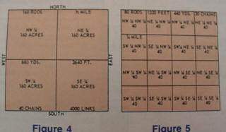
A land description is a description of a tract of land in legally acceptable terms, so as to show exactly where it is located and how many acres it contains.
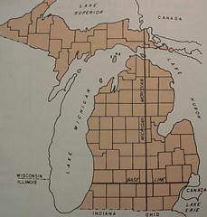
The U.S. Land Office originally subdivided Michigan,
most of the U.S., west of the Mississippi River and north of the Ottic
River, plus Alabama, Mississippi and portions of Florida under the U.S.
Public Land Survey. This office organized land descriptions into a series
of townships, ranges and sections.
All county court houses keep the original surveys. When Michigan was first surveyed, engineers knew that it was impossible to keep true north and south direction of township lines and still keep getting township squares of 36 miles.
Because of very large tracts of land,
like the size of Michigan, as it was surveyed toward the North Pole,
engineers were constantly running out of land as the township lines
were converging toward the North Pole - Have you ever noticed a road
which runs through the county, at the county line, it does not line
up exactly with the opposing county road? There seems to be a "jog"
of 100 feet or so?
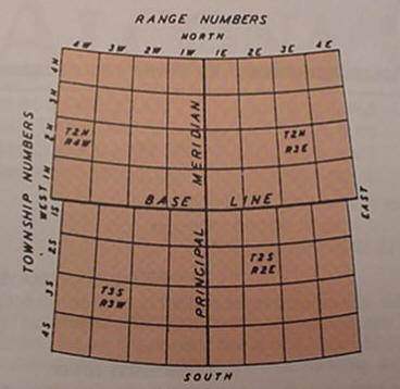
The above
map shows the Base Line....running east and west.
Each township has a township number, which is the number of rows or tiers of townships that a township is either north or south of the base line. Each township also has a range number which is the number of rows or tiers of townships that a township is either east or west of the principal meridian.
The sections within a township are numbered in a serpentine manner, always beginning in the township's northeast corner and ending in the southwest corner of the township.
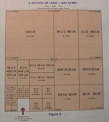
The best
way to read land descriptions is from the rear or backwards. Descriptions
of land are always read first from either the North or South. Every
description of land should show the section, township and range it is
located in. Townships may be located either north or south of the base
line, and ranges may be either east or west of the principle meridian.
Finally,
township, range and the section number should be added to the land description
to make it correct or proper legal description of a tract of land.
|
| Maps | Downtown Points Of Interest |
| How To Read A Land Desription | Bureau of Land Management (BLM) Land Patent Records |
| Portage Plats | Understanding Legal Land Description - Rootsweb |
All rights
reserved.
This site may be freely linked to but not duplicated
in
any fashion without my consent.
The information on these pages is meant
for personal genealogical
research only and is not for commercial use
of any type.