

|
KALAMAZOO COUNTY, MI CEMETERY MAPS |
![]()
BY COURTESY OF THE KALAMAZOO VALLEY GENEALOGICAL SOCIETY
 |
![]()
CLICK ON IMAGES TO ENLARGE
|
SOUTHEASTERN
CEMETERIES 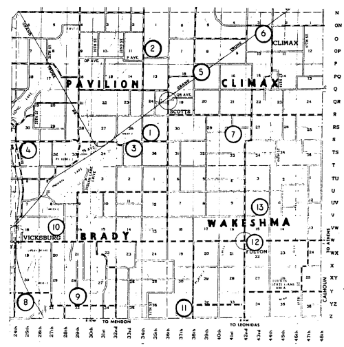
|
SOUTHWESTERN
CEMETERIES 
|
|
| Key: | Key: | |
| 01 Boughton | 01 Hope | |
| 02 Cook | 02 Pretty Lake | |
| 03 McKain's | 03 Virgo | |
| 04 Sand Lake | 04 Dry Prairie | |
| 05 Gilson | 05 Indian Fields | |
| 06 Prairie Home (Climax) | 06 Portage Center | |
| 07 Harrison | 07 Portage South | |
| 08 Clement | 08 Barber | |
| 09 German Lutheran | 09 Fellows | |
| 10 Jenkinson | 10 Harrison | |
| 11 Beard | 11 Pleasant Valley | |
| 12 Fulton South | 12 Shaver | |
| 13 Fulton North | 13 Gourdneck Prairie | |
| 14 Schoolcraft | ||
| 15 Vicksburg |
CLICK ON IMAGES TO ENLARGE
|
NorthEastern Cemeteries  |
NORTHWESTERN
CEMETERIES 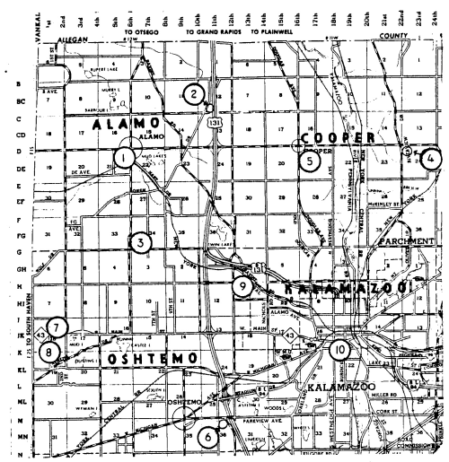 |
|
| Key: | Key: | |
| 01 Prairie Home | 01 Alamo | |
| 02 Augusta | 02 Green Bower | |
| 03 Day | 03 Liberty Street | |
| 04 Fort Custer National | 04 East Cooper | |
| 05 Howlandburg | 05 West Cooper | |
| 06 Ross | 06 Genesee Prairie | |
| 07 Yorkville | 07 Hill | |
| 08 Comstock | 08 West Oshtemo | |
| 09 Ford's Hill | 09 Grand Prairie | |
| 10 Galesburg | 10 South West Street | |
| 11 Maple Grove | ||
| 12 Oak Grove | ||
| 13 Shafter | ||
| 14 Wheaton | ||
| 15 County Farm | ||
| 16 Lawler | ||
| 17 Riverside (Charleston Twp) | ||
| 18 Roof | ||
| 19 Toad Hollow |
| Cemetery Diagrams | Funeral Homes |
All rights reserved.
This site may be freely linked to but not duplicated
in any fashion without my consent.
The information on these pages is meant for personal
genealogical
research only and is
not for commercial use of any type.