CHAPTER L:
VILLAGE ROADS AND CITY STREETS.
Sections of Chapter:
Village Roads and City Streets
Early Wagon Roads
First Village Roads
Laying Out Streets
Their First Condition
Further Plattings
Grading, Cutting and Filling
Number and Length of Streets
Street Numbering
Pavements
Street Sidewalks
Derivations of Street Names
Changes of Street Names
VILLAGE ROADS AND CITY STREETS.
|
The primitive roads of the little village of Grand Rapids were devious,
winding ways, and hard roads to travel. At first they were only the Indian
trails or foot-paths. A trail from the southeast came in past Reeds Lake,
to about where Lake avenue now joins Fulton street, and thence in a zigzag
course down to the river near the foot of the rapids. A lighter trail came
in at Coldbrook, and along the west base of the bluffs or next the river
bank to the lower part of town. Another came from the southeast, entering
about where State street is, and from there pursuing a serpentine course
to and around the southern base of Prospect Hill, rounding its angle near
the foot of Monroe street, thence circuitously to the fur-trading station
at the foot of Huron street. There was also a trail that came up near the
river from Grandville, leading to the same point. On the west side were
the trails from Grand Haven and Muskegon, and such Indian hunting grounds
as lay in that direction, and another from
Naturally the first wagon roads to the village came in by or near those paths which the Indians had trod, and were correspondingly crooked; and for some years little or nothing was done to straighten and improve them except by private enterprise. The Thornapple road came in by the trail first mentioned to Fulton street and down a ravine toward the junction of Jefferson avenue and State street. The Bostwick Road, as it was called, came in from the direction of Green Lake, its entrance being about where now is the State street line. From the southward the early farmers drove in by way of the present site of the fair ground, and along the edge of the dry land some distance east of Division street. A road from the southern part of the county, or that portion of it west of the Division street line produced southward, joining another that came up the river, formed the one which is still known as the Grandville Road. Within the present limits of the city, during the village days, and even as late as 1850, there were wagon roads winding in in various directions, unfenced, and unworked save by the wear of travel. The most feasible passage from the head of Monroe street to the Bridge street bridge, when that was built, was by a wagon track passing the National Hotel corner, skirting along the eastern slope of Prospect Hill a little west of Ionia street, crossing in a muddy gully the little creek which formerly ran around the north end of the hill, and picking the way carefully over dry spots and past bogs near Kent to Bridge street, thence through a miry slough to the bridge. A similar wagon track ran in a zigzag course near the foot of the hill from Coldbrook to Bridge street. The road toward Plainfield sought the dry places, but did not escape all the muddy ones. Nowhere within the village limits was there a good east and west wagon road. From Fulton street east of the public square was one that climbed the hill in a northeasterly direction through a ravine which reached the summit a little east of where the Central School building now stands, and thence wound its way among the oak grubs back to the Thornapple Road. On the west side were less of ups and downs, but there was plenty of variety in the alternating patches of stony and gravelly and miry grounds, and for nearly twenty years the teamster chose his route (inside of what is now the town) over unfenced lands, through bushes and past the bad places, by what appeared to be the most feasible way. This condition of things has long since passed, and it is only by the eye of the mind that one can see and comprehend the great change that has taken place from the ragged, original roads to the handsomely graded streets. Streets there were in Grand Rapids---on paper---almost as early as there were roads, yet they were very little and very imperfectly worked and improved during the first twelve or fifteen years. In the year of the first settlement, 1833, Toussaint Campau procured the platting into streets, blocks and lots, of the south half of the northeast fractional quarter of section 25,T.7N., R.12 W. The plat included the portion bounded by a line lying midway between Pearl and Lyon streets on the north, Division street on the east, Fulton street on the south, and the river on the west. Louis Campau, who entered this land, insisted that the main street be laid as near as might be on the Indian trail which came down from the southeast past the foot of Prospect Hill. That is Monroe street. Between that and Fulton street, the streets intersecting Monroe, were laid at right angles with the latter. This accounts for the diagonal street-pattern of that small section of the city. On the other side of Monroe street the cross streets were laid due north and south. On that plat, and within about twenty rods of the present geographical center of the city, was built the pioneer house. IN 1835 and 1836 was platted the rest of the territory bounded north by Coldbrook street, east by a line about four rods further east than Ransom street, south by the section line (Wealthy street), and west by the river. The streets were laid 66 feet wide--which is about the average width of nearly all the streets in the city--except that Canal street from Pearl to Bridge was laid 100 feet, and north of Bridge 92 feet; East Bridge street to the top of the hill, 100 feet, and Monroe street one and a quarter chains. In the platted portion of the town during the village days comparatively little was done toward permanent improvement of the streets. They were simply made passable as common roads through the districts occupied by residences, with occasional patches of narrow plank sidewalks, and little plank or log bridges across streams and mud-holes; most of the work being done on the country road plan, and many of the citizens personally working out their highway or capitation taxes. Something more was done by private enterprise at places along Monroe, Waterloo and Canal streets, and other points where there were clusters of stores or shops or business houses, whose proprietors indulged in walks made of plank laid lengthwise, from four to six or eight feet wide, in front of their places of business. Yet as late as 1845 the roadway of Monroe street, with rather a steep descent from Ottawa down, was, in wet weather, like a bed of brickyard mortar; while Canal street for nearly its whole length was a stretch of black mire of such uncertain depth that only unlucky teamsters often found the bottom. Across that street, about twenty rods north of Lyon, ran a small creek, over which was a narrow plank bridge with log abutments. About 1850 began the era of public, systematic improvement of the streets. Additional plats were made from time to time, until, in 1853, three years after the city was incorporated, as a city map then made shows, there were within its limits (two miles square) besides those already mentioned, the following: On the East Side--Morrison's Addition, 59 lots, south of Cherry street and east of Jefferson avenue. Smith's Addition, bounded north by Washington street, east by the section quarter line, south by Cherry street, and west by Jefferson avenue. Campau's Second Addition, containing three blocks south of Fulton and east of Lafayette street. Kendall's Addition, bounded north by Bridge street, east by the quarter line, south by Fulton street, and west by a line midway between Barclay and Lafayette streets. Williams' Addition, three lots north of Cherry street and east of College avenue. On the West Side---Scribner's Addition, bounded north by Bridge street, east by West Division, south by the center line of section 25, and west by the section line. Coggeshall's Addition, bounded north by Bridge street, east by Grand River, south by the center line of the section, west by West Division street. Cuming's Addition, north of West Bridge street, between West Division (now Seward) and Stocking. Scribner & Turner's Addition, bounded north by the quarter line of section 24, east by Grand River, south by West Bridge street, and west by West Division (now Seward) street. Smith & Van Allen's Addition, bounded north by Eleventh street, east by Grand River, south by Scribner & Turner's addition, and west by West Division (now Seward). Richmond's Addition, a strip north of Smith & Van Allen's Addition, running from the river to the line of West Division (Seward) street. Tryon's Addition, ten lots north of Richmond's Addition, and lying between Front and Broadway. (That Seward street--formerly West Division--line is where the railroad tracks lie, north from West Bridge street.) Plats made since 1853, of which there are upward of 150, need not be mentioned in detail. Suffice it to say that they are all of record for the examination of those interested, and cover not only nearly the entire nine square miles now within the city, but considerable outlying ground on every side. The more prominent accretions since those above described have come by the platting of the large Ellsworth, Grant and Campau- farm properties, the "Penney eighty," and others to the south. A large proportion of the others are smaller plats or subdivisions. The suburban plat of Charles C. Comstock, on the north, is a large and valuable tract. Turning again to the streets--their improvement has involved a vast amount of labor and expense. There are few cities where it has been necessary to do so much cutting and filling as in that part of our own east of the river. In Ottawa, Lyon and Pearl, deep excavations through the solid clay of Prospect Hill have been made, necessitating also the grading down of adjacent property to the extent at some points of nearly forty feet below the former level. In Lyon and Bridge streets excavations through the brow of the sand hill have been about as deep, and all the east-and-west streets rising that hill have cost a great amount of digging. Considerable cutting has also been done on Division street immediately south of Fulton and again to modify the grade where was formerly a steep clay hill from Cherry street to Goodrich; also in the streets passing through the hills between Almy street and the river, and southward well toward Plaster Creek. On the west side not so much excavating has been necessary except in a comparatively small section near the northwest corner of the city. The amount of filling done has been something enormous. The grade of Canal street at the lower end has been raised nearly fifteen feet, and throughout its entire length an average of not far from four feet; and almost all the low grounds north of East Bridge street have been raised nearly as much by the deposit of earth brought from the adjacent hill. The raising of the grounds on what were formerly the Islands at Pearl street and blow, and the filling of the east channel of the river in that vicinity to the present grades, have also furnished places of deposit for vast amount of earth from the hill excavations, seemingly without much drain upon the sources of supply. A large area in the neighborhood of the Union Depot has been filled from two to eight or ten feet; also a portion of Division street directly east of that station. Most of the street grading on the West side has been upward instead of downward, and a considerable proportion of the material therefor has been hauled a long distance. The heaviest part of it was which lay west of Turner and north and south of Bridge street, and of a ravine through which the waters flowed, coming to the river a short distance south of Bridge street. This class of improvements has kept the city busy upward of thirty-five years from their beginning, and the end is not yet. The streets of Grand Rapids are in general very regularly laid, crossing
at right angles, with comparatively few exceptions. A slight fault, apparent
to one who looks at a map of them, is in the number of short streets. Leonard,
Bridge and Fulton, being on section lines, run entirely across the city
from east to west, each two and a half miles long. East street is the only
one running straight through from north to south, three and a half miles,
and next to that in length is College avenue. Lafayette street runs from
the south line of the city directly through to the D., G. H. & M. Railway,
a distance of about two and a half miles. Division street, on the range
line, has its north end at Bridge street and is two miles long. Canal street,
from Pearl street to the north line, less than two miles lone, is straight
for a little more than half the way, the upper part being angled to conform
to the course of the river. Front street is very nearly straight from the
north end to Fulton, two miles, thence fro another half mile veers slightly
westward. Scribner, Turner and Broadway, with connection streets southward,
afford nearly straight thoroughfares from Fulton street to the north line
of the city--two miles. Enumerated by name, the number of streets is (in
1888) about 360, and their aggregate length about 144 miles. On January
1, 1888, there were:
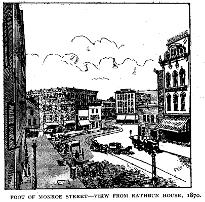
The numbering of streets at first was very irregularly done. In the village days it was not attempted. Merchants were content to simply mention the street, and sometimes approximately what part of the street they were on, in their advertisements. To say "near the bookstore," " near the Bridge Street House," "Canal street, near Bronson," "foot of Monroe street," or to use some similar briefly descriptive phrase, was generally deemed sufficient to convey information as to any particular locality. And this method prevailed, till some time after the incorporation of the city. The names and locations of the more prominent buildings, such as the leading hotels, Backus Block, Commercial Block, Rathbone Block, Irving Hall, Faneuil Hall, and others, were quite as well known in all the country about as in the town. Numbering first began to correspond with the numbers of the lots on which the buildings were situated, but this plan was soon found too crude; though as late as spring of 1865 the Common Council passed a resolution requesting residents to number their places of residence by that rule. But immediately they reconsidered it, and decided to commence the numbering of Canal street at the foot and number northward, to number Pearl and Monroe from the foot eastward, and to number first the business portion of the city in conformity therewith. Later, in 1873, a more comprehensive system was adopted, and prevails to this day, so that in general, streets on the east side are numbered from the river eastward, and north and south each way from Fulton street; while on the West Side the numbers run from the river westward, and from West Bridge street north and south. In 1873 $200 was expended for placing signs at street corners, but the absence of those guides at many corners is yet noticeable. The first effort toward anything like paving the streets, was the construction, about 1847, of a piece of macadamized road from Bridge street southward on Canal. A thin layer of sand and gravel was put upon the soft, deep mud, and top dressed with broken limestone. It was a good road bed for a short time, and then began to break through in spots, making it very rough, and dotted with deep mire holes, so that the last end of that venture was worse than the first. The next slight advance was the laying, in 1849, of a plank road up the sandy part of Fulton street hill east of Jefferson avenue. A short stretch of the steep part of Fountain street was also planked. But these were short-lived devices. The construction of the Kalamazoo plank road in 1855 made for a few years passably good pavement of oak plank from the south city line on Division street to Monroe. In the following year began street paving in earnest--the first being that of Monroe with cobble stone as far up as Ionia, and this a little later was extended to Division street. In 1859 Canal street was similarly paved, as far north as Hastings street. Cobble stone, well laid on a solid, even bed, is a good pavement, indefinitely durable, but very noisy, and hard upon the horses' feet. Not much progress was made in paving during the war period, but in 1866 the Monroe street paving was extended to its junction with Fulton street, and the latter was paved from that point east over the hill to its junction with Lake avenue, with round stone. About that time also was extended the Canal street paving north, and in 1868 it was completed to the D., G. H. & M. Railway Depot. A change from stone to wood pavements was made about 1874. The first wood pavement tried was of blocks cut from four-inch pine plank, set on end upon a gravel bed, the interstices between the blocks well tamped with gravel and sand, making a wood roadway six inches in depth. Pearl and the lower part of Monroe street were the first to be treated in this way. Soon afterward Canal street was repaved in the same manner. After this, little, if any, stone pavement was laid, except along street borders and gutters. Wood pavements were put in Lyon, West Bridge, and some other streets in 1875 and 1876. The pine pavement did not prove very lasting, the wood decaying in five or six years. The next advance was in the use of cedar blocks cut from the bodies of small trees in six inch lengths, the bark and sap-wood trimmed off, and the blocks set on end. These were first used in Pearl street from Canal street to the bridge, and in Monroe street, by way of experiment. The cedar block has proved much the more durable, and is the popular pavement to this day. Among the principal thoroughfares a good portion of which is now paved, are Canal street, Bridge (East and West), Lyon, Pearl, Monroe, Kent, Ottawa, Fulton, Division and Jefferson avenue. Sidewalks in Grand Rapids, with the exception of a few short stretches of stone or cement, are of wood; two-inch pine or hemlock plank, in general, laid crosswise on stringers and well spiked down. They are of widths varying from four to eighteen feet, according to the needs and uses of the streets in which they lie, those in the residence districts averaging six feet. At the start, the village days, the temporary walks were usually voluntarily laid by those in front of whose premises they were needed. Generally they were only such as were absolutely necessary to keep the feet of pedestrians out of the mud; often not more than two or three feet wide, of planks laid lengthwise rather loosely on sleepers and without much regard to the ups and downs of street grades. But since the incorporation of the city they have been gradually bettered and extended, until they line nearly every inhabited street, and these wooden walks are as good as those of any city, or as can be made of that material. There are handsome and solid walks of dressed stone in front of the business places on the lower part of Monroe street, and near by on some of the intersecting streets. Very fine walks of this character also surround the Government Block, and three side of the City Hall. The stone for these is brought mostly from other States. The first walk of this kind was laid in Monroe street. Recently, on West Bridge near Turner street, at the corner of Canal and Crescent avenue by the Grinnell Block, in front of Powers' Opera House Block, by the Hermitage Block, at the corner of Bridge and Canal, and at several other points, experiments have been made in putting down walks of artificial stone, or concrete made of cement, sand and gravel. These are molded in blocks to suit the locality, usually of lengths corresponding with the width of the walk, and six or eight inches in thickness. The moulding is done on the spot, and when dry and hardened they are apparently as solid as granite rock. This walk is handsome and gives promise of being durable and permanent as stone, judging from the short trial it has had here, of only two or three years. Names not infrequently are of themselves historic. Many of the street names here may have been given from mere fancy, or for the simply purpose of distinction only. But in many cases they have associations with persons or things or events. In most cases where a street bears the name of an individual it is thus named as a compliment. A peculiarity in the situation of a street may give the name. A number of the streets of Grand Rapids have taken their names from those of prominent streets of other cities. An attempt will here be made to explain the derivation of some of the street names, though comparatively only a few. Adams and Allen--From individuals formerly living near them.
Many streets of the city are named for the platters of grounds near where they lie, or by them in honor of their children or other relatives. Some of these will be readily recognized. Further specifications are unnecessary. Some changes from early names are mentioned elsewhere, and of some of them it may be said that the new names are no improvement upon the original ones. Following are most of the changes in street names made by the Common Council in the last thirty years: August 25, 1860: the four streets, Jefferson, South, Penney, and Withey streets, forming one continuous street from Fulton on the north, to the city line on the south, were named Jefferson avenue. January 5,1865: Court, north of Bridge, changed to Lincoln. West Division north of Bridge, to Seward. May 28, 1866: Grove and Rebecca, to continuation of Turner. May 19, 1868: Stone, to continuation Fifth. June 27, 1868: Louis, between Cherry and State, to Luce. July 12, 1869: Caroline, to continuation of South Lafayette. July 11, 1870: Lincoln to Scribner. March 1, 1873: Plainfield road to Plainfield avenue. July 12, 1873: East street on Withey's add., to Sycamore; Greenwich, Prairie and Grant streets, to continuation of Ionia; Justice to continuation of Ottawa; East Water to Waterloo; First, Second, Third and Fourth streets, Grant's add., to First, Second, Third and Fourth avenues respectively; Newaygo State road to Walker avenue; Butterworth road to Butterworth avenue; Thornapple road to Lake avenue; William street, Eighth Ward, to Peaslee; New York and Shawmut streets to Shawmut avenues; Fremont to Bowery; Washington, Eighth Ward, to Sibley; Fremont, Eighth Ward, to Watson; Centre, Eighth Ward, to Shepard; Charles, Eighth Ward, to Hovey; Curtis, Eighth Ward, to Chubb; West Water to South Front; Siegel to Jefferson; Ann, Sixth Ward, to Eighth; Elizabeth, Sixth Ward, to Ninth; Caroline, Sixth Ward, to Tenth; Jonathan, Sixth Ward, to Eleventh; Franklin, Sixth Ward, to Twelfth; Pine, Sixth Ward, to Tamarack; Union, Sixth Ward, to Cypress; Centre, Fifth Ward, to Cedar; Park, Fifth Ward, to Columbus; Cemetery, Fifth Ward, to Taylor; Coldbrook, Brown & Drew's add., to Vine; Park, Brown & Drew's add., to Walnut; Grand, Eighth Ward, to West Fulton; High, Third Ward, to Charlotte; Official (a short street forming an angling connection between Spring and Monroe streets), to Spring; Canal, south of Pearl, to Monore. October 11, 1873: North Withey to McConnell; McConnell to Third avenue; Mary to continuation of Second avenue; Ellsworth to continuation of Cherry; Elm to Goodrich; Fremont to Fourth avenue; Powell to continuation of South Lafayette; S. Withey to Withey; Ann and Smith to continuation of South Prospect; King, north from Quimby, to Queen; Mason and Fair to Muskegon; Dayton to Pettibone; Bank, West Side, to Michigan; Locust avenue to continuation of Davis; Butterworth avenue, north of Fourth, West Side, to Reynolds. October 12, 1874: Charlotte to Madison avenue. July 12, 1875: part of Coldbrook to continuation of Canal. October 15, 1877: Withey and Winsor to Fifth avenue. August 23, 1880: Cypress to Alpine avenue. October 1, 1883: Tile to Reed. August 17, 1885: Bronson to Crescent avenue. May 9, 1885: Holland to Irving place. November 23, 1885: Summit to Ellsworth avenue. November 29, 1886: Antoine to Sixth avenue; Evergreen to Seventh avenue; Cottrell to Eighth avenue; Adams to Ninth avenue; Shelby to Tenth avenue; Putman to Eleventh avenue; Canton to Twelfth avenue. March 19, 1888: Crab Apple Alley to Brenner Court. April 16, 1888: Cemetery to North East. Among changes of street names not recorded in the Book of Ordinances
are the following:
|
||||||||||||||||
Document Source: Baxter, Albert, History of the City of Grand Rapids, New York and Grand Rapids: Munsell & Company, Publishers, 1891.
Location of Original: Various.
Transcribers: Ronnie Aungst
Created: 8 August 1999