St. Clair County, Michigan History and Geography of St. Clair County |
A brief history, a small map and a table showing information about the county's townships, cities, villages and other populated places. There are also links to other internet sites that can provide more information. by Tom Kephart.
A Brief History of Michigan and St. Clair County
by Tom KephartFrench explorers, looking for a passage to China through the unexplored North American continent, visited what is now Michigan in the early 1600s. The native people gave the visitors some much-needed assistance during their journeys, building and navigating canoes, protecting and teaching them about the environment, and helping them forage and hunt for food. The Indians also traded animal furs for guns, powder, ammunition and other tools that moved their culture into the dawn of the Industrial Revolution.
In 1679, the French explorer Robert Cavelier de la Salle and French missionary Pčre Louis Hennepin entered a body of water while sailing on the Griffon up from Lake Erie on what is now the Detroit River. The date was 12 August 1679, which was the day of the religious festival of Sainte-Claire, who founded the order of Franciscan nuns in the 13th century. Ste.-Claire was a contemporary and friend of St. Francis of Assisi. Pčre (Father) Hennepin held a mass, during which the newly-discovered lake was given the name Lac Sainte-Claire. In time, the river leading north out of Lac Sainte-Claire, the county that developed along it, and a city on the river all took the same name St. Clair. (The name was often spelled St. Clare in English in the 1700s, but most mapmakers had settled on the current spelling by 1840.)
The profits being realized by the French traders prompted British traders from New-York and Hudson's Bay to try to get a share of the business themselves. In response, French governeur Antoine de la Mothe Cadillac established Fort Ponchartrain and the Détroit settlement in 1701. (The name Detroit comes from the French d'étroit, meaning "at the narrows.") The French and British fought four wars, primarily over the valuable fur trade in the Great Lakes regions, ending with the eventual withdrawal of the French from Forts Pontchartrain, St.-Joseph in western Michigan, and Mackinac in northern Michigan.
The British garrisoned these forts, but some Indians, many followers of Chief Pontiac, attacked in hopes of returning their friends, the French, to power in the region. After the Seven Years War ended with a peace treaty in 1763, the native people learned to accept the British, who in turn realized the value of protecting the fur trade from encroaching settlers, much as the French had. The British built Fort Sinclair near the entrance to the St. Clare River at the southern end of Lake Huron in 1765. During British rule, little changed culturally: fur trading, farming, religion and place names remained mostly of Indian or French origin, and those two cultures influence would continue to be felt in Michigan well after the American nation was established.
During the Revolutionary War, what is now Michigan, then part of the British province of Québec, remained loyal to King George III. Although the popular view of the war of American independence is that George Washington's army defeated the British, in fact it was a war of attrition that the much better equipped British could have prolonged indefinitely. In the Great Lakes region, the British were superior in numbers, in fortifications, in supplies and in knowledge of the terrain, plus they had the Indians as their allies. But the king's military advisors told him the facts: while the Americans probably couldn't win, neither could the British. Tiring of the expensive war, King George gave in and granted independence to the 13 former colonies, although the British resisted giving up their Great Lakes forts until 1796.
Michigan was initially part of the Northwest Territory under Thomas Jefferson's Northwest Ordinance of 1787. In 1800, the western half of the state was made part of the Indiana Territory. Ohio became a state in 1803, and the remainder of the old Northwest Territory was added to the Indiana Territory. In 1805, Michigan Territory was created by Congress, consisting of today's Lower Peninsula and a small section of the eastern Upper Peninsula. The southern boundary of the territory was from the southern tip of Lake Michigan to the mouth of the Maumee River, land which is today part of the states of Indiana and Ohio. In 1816, Indiana entered the Union, claiming its current boundary with Michigan, and the Illinois Territory was created to administer the remaining Indiana Territory lands. When Illinois also achieved statehood in 1818, the Michigan Territory was expanded to include all of the current state of Michigan, plus Wisconsin and part of what is now Minnesota.
St. Clare County was set off from what was then Wayne County by a proclamation of Governor Lewis Cass of the Michigan Territory on 28 March 1820. It included lands that are now Huron and Sanilac Counties, and parts of what would become Tuscola and Macomb Counties. St. Clair County was the first stopping place for many immigrants from Canada who crossed the St. Clair River at the town of Sarnia in Upper Canada to Port Huron in the United States. Some continued to move west toward Flint and the new state capital at Lansing, and southwest toward Pontiac and Detroit, but many stayed and settled in St. Clare County, primarily along the river since few roads were available, and the river made transportation possible, as it had in the French trading days and as it still does today.
In 1834, lands in modern-day Minnesota, Iowa, North Dakota and South Dakota were annexed to the Michigan Territory. When Michigan became the 26th state in 1837, the remaining territorial lands became the Wisconsin Territory. Michigan also ceded the "Toledo Strip" to Ohio, establishing the current border with the Buckeye State, and was awarded the Upper Peninsula in return. Not many people thought this was a good deal in 1837, but it turned out to be very beneficial to the young state, particularly after the discovery of copper and gold in the U.P. during the late 1800s.
In 1836, St. Clair County took its current shape for the first time, when newly set off Lapeer County was given lands in the Thumb region. But in 1840, Lapeer was cut off by Saginaw County, and St. Clair was again given administrative control over much of the Thumb. In 1852, Sanilac County was created, taking with it the future Huron County as well, and St. Clair County was established in its modern-day configuration.
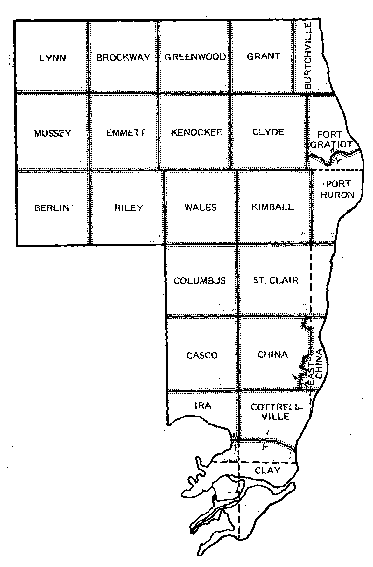
St. Clair County Townships
Geography of St. Clair County
Bounded on the north by Sanilac, on the west by Lapeer and Macomb Counties, and on the east by the province of Ontario, Canada, the interior of St. Clair County remains largely rural, with agriculture and related activities making up the bulk of the economy. However, along the shorelines of Lake Huron and Lake St. Clair and the banks of the St. Clair River, cities such as Port Huron, St. Clair, Marine City and Algonac grew up on ship-building, chandlery, and other port activities. Today the suburban sprawl of the Detroit metropolitan area reaches well into the southern part of the county.
St. Clair County covers 700.27 square miles. There are 23 survey townships in the county. A list of all of the townships, plus the cities, villages and towns in the county, is below. Where available, a link to the census demographics is provided; this data is courtesy of the Michigan Dept. of Management and Budget. The township and range identifier for each township is shown in the second column; for other places, the name of the township where the city, village or town is located is shown.
NOTE: For the purposes of this table, a "town" may be either: (1) a Census Defined Place (CDP); (2) an unincorporated populated place; or (3) a "ghost town," which may or may not have any current population, but is shown for the historical researcher.
The US Geological Survey and the Bureau of the Census have placed a huge amount of geographic data online. By taking advantage of their databases, we can view lists of features, locations, and even see maps of the selected region. Here are two examples:
United States Geological Survey information about St. Clair County ~ A list of all St. Clair County features, including population clusters, cemeteries, townships (civil), churches, etc. from the USGS database. This kind of list can be very helpful, as many of these places are locally-known names that can appear in family records yet have never been incorporated as towns or cities that appear on a map or postal directory.
The US Gazetteer Population, zip code, and simple locator maps for incorporated cities and towns.
Sources
- Michigan County Atlas (Williamston, MI: Universal Map, 1988?)
- Michigan Department of Management and Budget
- St. Clair County Directory (1999-2000 edition)
- Schramm, Jack E., et al, When Eastern Michigan Rode The Rails, Book Two (Glendale, CA: Interurban Press, 1986)
- Sommers, Lawrence M., ed., Atlas of Michigan (East Lansing: Michigan State University Press, 1977)
- U.S. Postal Service
| Place Name | Address or Post Office/Zip | Range/Township Identifier or Township |
Date Incorporated as Township or Village |
Date Incorporated as City |
1990 Population |
Notes |
|---|---|---|---|---|---|---|
| Town of Abbottsford | Kenockee & Clyde Townships | |||||
| Town of Adair | Casco Township | |||||
| City of Algonac | 805 St. Clair River Dr. Algonac, MI 48001 (810) 794-9361 |
Clay Township | 1867 | 1967 | 4,551 | |
| Town of Allenton | Allenton, MI 48002 | Berlin Township | ||||
| Town of Anchorville (CDP) | Anchorville, MI 48004 | Ira Township | ||||
| Town of Atkins | Clyde Township | |||||
| Town of Avoca | Avoca, MI 48006 | Kenockee Township | ||||
| Town of Bedore | Clay Township (Harsens Island) | |||||
| Town of Belle River | Columbus Township | |||||
| Town of Belle River Mills | China Township | |||||
| Berlin Township | 13892 Hough Rd. Allenton, MI 48002 (810) 784-9717 |
T6N, R13E | 23 Mar 1839 | 2,407 | ||
| Town of Berville | Allenton, MI 48002 | Berlin Township | ||||
| Town of Blaine | Grant Township | |||||
| Town of Broadbridge Station | Cottrellville Township | |||||
| Town of Brockway | Yale, MI 48097 | Brockway Township | ||||
| Brockway Township | 7645 Sayles Rd. Yale, MI 48097 (810) 387-2052 |
T8N, R14E | 17 Mar 1848 | 1,609 | ||
| Burtchville Township | 4000 Burtch Rd. Lakeport, MI 48059 (810) 385-5577 |
T8N, R17E | 16 Feb 1842 | 3,559 | ||
| Village of Capac | 131 N. Main St. P.O. Box 218 Capac, MI 48014 (810) 395-4355 |
Mussey Township | 1873 | 1,583 | ||
| Town of Casco | Casco, MI 48064 | Casco Township | ||||
| Casco Township | 4512 Meldrum Rd. Casco, MI 48064 (810) 727-7524 |
T4N, R15E | 4,552 | |||
| China Charter Township | 4560 Indian Trail China, MI 48054 (810) 765-1145 |
T4N, R16E | 17 Mar 1834 | 2,644 | ||
| Clay Township | 4710
Pte. Tremble Rd. P. O. Box 429 Algonac, MI 48001 (810) 794-9303 |
T2N, R15E | 1828 | 8,862 | ||
| Town of Clays Landing | Clay Township (Harsens Island) | |||||
| Clyde Township | 3350 Vincent Rd. North Street, MI 48049 (810) 985-7258 |
T7N, R16E | 26 Mar 1836 | 5,052 | ||
| Town of Columbus | Columbus, MI 48063 | Columbus Township | ||||
| Columbus Township | 1732 Bauman Rd. Columbus, MI 48063 (810) 727-2055 |
T5N, R15E | 11 Mar 1837 | 3,235 | ||
| Cottrellville Township | Marine City, MI 48039 | T3N, R16E | 12 Apr 1827 | 3,301 | ||
| Town of Doyle | Riley Township | |||||
| East China Charter Township | 5111 River Rd. E. China, MI 48054 (810) 765-8879 |
T4N, R17E | 12 Feb 1859 | 3,216 | ||
| Village of Emmett | P.O. Box 127 Emmett, MI 48022 (810) 384-6991 |
Emmett Township | 1883 | 297 | ||
| Emmett Township | 11100 Dunnigan Rd. Emmett, MI 48022 (810) 384-8070 |
T7N, R14E | 19 Feb 1850 | 1,519 | ||
| Town of Fair Haven (CDP) | Fair Haven, MI 48023 | Ira Township | ||||
| Town of Fargo | Greenwood, MI 48006 | Greenwood Township | ||||
| Town of Forster | Clay Township (Harsens Island) | |||||
| Fort Gratiot Charter Township | 3720 Keewahdin Dr. Ft. Gratiot, MI 48059 (810) 385-4489 |
T7N, R17E | 13 Jun 1866 | 8,968 | ||
| Town of Gardendale | Fort Gratiot Township | |||||
| Town of Goodells | Goodells, MI 48027 | Wales Township | ||||
| Town of Grande Point | Clay Township (Harsens Island) | |||||
| Grant Township | 8512 Jeddo Rd. Jeddo, MI 48032 (810) 327-6775 |
T8N, R16E | 9 Oct 1866 | 1,210 | ||
| Greenwood Township |
9025 Yale Rd. |
T8N, R15E | 12 Feb 1855 | 1,037 | ||
| Harsens Island | Harsens Island, MI 48028 | Clay Township | ||||
| Town of Hawthorne | East China Township | |||||
| Ira Township | 7085 Meldrum Rd. P.O. Box 230555 Fair Haven, MI 48023 (810) 725-0263 |
T3N, R15E | 11 Mar 1837 | 5,587 | ||
| Town of Jeddo | Jeddo, MI 48032 | Grant Township | ||||
| Kenockee Township | 4420 Kilgore Rd. P.O. Box 400 Avoca, MI 48006 |
T7N, R15E | 9 Feb 1855 | 1,854 | Pronounced "ken OH kee" | |
| Town of Keewahdin | Fort Gratiot Township | |||||
| Town of Kimball | Kimball, MI 48074 | Kimball Township | ||||
| Kimball Township | 1970 Allen Rd. Kimball, MI 48074 (810) 987-9797 |
T6N, R16E | 12 Feb 1855 | 7,247 | ||
| Town of Lakeport | Lakeport, MI 48059 | Burtchville Township | ||||
| Town of Lambs | Wales Township | |||||
| Town of Lesterville | Berlin Township | |||||
| Lynn Township | 15819 Dudley Rd. Brown City, MI 48416 |
T8N, R13E | 18 Mar 1828 | 921 | ||
| Town of Mapleleaf | Clay Township (Harsens Island) | |||||
| City of Marine City | 300 Broadway Marine City, MI 48039 (810) 765-8830 |
Cottrellville Township | 1865* | 1887** | 4,556 | *as Village of Newport; later
changed to "Marine" **as City of Marine City |
| City of Marysville | 1111 Delaware Marysville, MI 48040 (810) 364-6613 |
Port Huron & St. Clair Townships | 28 Oct 1919 | 8,515 | Original name was Vicksburg, after E.P. Vickery, who built a sawmill there in 1840s. In 1860s, he sold the mill, and the town was renamed after one of the new owner's wives, Mary. | |
| City of Memphis | 35095 Potter St. P.O. Box 86 Memphis, MI 48041 (810) 392-2385 |
Riley Township (also part in Richmond Twp., Macomb County) | 1865 | 1953 | 363 (in St. Clair County) |
|
| Town of Miller | Clay Township (Harsens Island) | |||||
| Town of Muirs | Clay Township (Harsens Island) | |||||
| Mussey Township | 135 N. Main St. P.O. Box 118 Capac, MI 48014 (810) 395-4915 |
T7N, R13E | 10 Feb 1855 | 1,530 | Pronounced "MOOS ee" | |
| Town of Muttonville | Casco Township | |||||
| City of New Baltimore | New Baltimore, MI 48047 | Ira Township (also part in Chesterfield Twp., Macomb County) | ||||
| Town of North Lakeport | Lakeport, MI 48059 | Burtchville Township | ||||
| Town of North Street | North Street, MI 48049 | Clyde Township | ||||
| Town of Pearl Beach (CDP) | Algonac, MI 48001 | Clay Township | ||||
| Town of Perch | Ira & Clay Townships | |||||
| Town of Peters | Casco Township | |||||
| Town of Pointe Aux Tremble | Clay Township | |||||
| City of Port Huron | 100 McMorran Blvd. Port Huron, MI 48060 (810) 984-9725 |
Port Huron Township | 1849 | 1857 | 33,694 | |
| Port Huron Charter Township | 3800 Lapeer Rd. Port Huron, MI 48060 (810) 987-6600 |
T6N, R17E | 12 Apr 1827 | 7,621 | ||
| Town of Rattle Run | St. Clair Township | |||||
| Town of Riley Center | Riley, MI 48041 | Riley Township | ||||
| Riley Township | 13016 Belle River Rd. Riley, MI 48041 (810) 392-2326 |
T6N, R14E | 6 Mar 1838 | 2,154 | ||
| Town of Roberts Landing | Marine City, MI 48039 | Cottrellville Township | ||||
| Russell Island | Russell Island, MI 48001 | Clay Township | ||||
| Town of Ruby | Ruby, MI 48049 | Clyde Township | ||||
| City of St. Clair | 411 Trumbull St. St. Clair, MI 48079 (810) 329-7121 |
St. Clair and China Townships | 1850 | 1858 | 5,116 | Originally Town of Palmer; changed to St. Clair in 1846. |
| St. Clair Township | 1539 S. Bartlett Rd. St. Clair, MI 48079 (810) 329-9042 |
T5N, R16E and T5N, R17E | 12 Apr 1827 | 4,614 | ||
| Town of Sans Souci | Clay Township (Harsens Island) | |||||
| Town of Smiths Creek | Smiths Creek, MI 48074 | Kimball Township | ||||
| Town of Snyderville | Columbus Township | |||||
| Town of South Park | Port Huron Township | |||||
| Town of Sparlingville (CDP) | Kimball Township | |||||
| Town of Starrville (Starville) | Cottrellville Township | |||||
| Town of Sunnyside Station | Kimball Township | |||||
| Town of Tappan | Port Huron Township | |||||
| Town of Thornton | Wales & Kimball Townships | |||||
| Town of Wadhams | Kimball Township | |||||
| Town of Wales | Goodells, MI 48027 | Wales Township | ||||
| Wales Township | 1372 Wales Center Rd. Goodells, MI 48027 (810) 325-1517 |
T6N, R15E | 27 Mar 1841 | 2,294 | ||
| Town of West Tappan | Kimball Township | |||||
| City of Yale | 111 W. Mechanic St. Yale, MI 48097 (810) 387-3311 |
Brockway Township | 1885* | 1905 | 1,977 | *as Village of Brockway Center; changed to Village of Yale in 1889 |
|
This page was last updated Thursday, October 14, 2021 |