 |

|
|
|
Early History The 6-by-6-mile square T6N-R9E was first settled in 1834, and became part of Lapeer Township, organized on 30 Dec 1834, which then included most of Lapeer County. Hadley Township was then organized on 22 Mar 1836, and included both T6N-R9E and T6N-R10E. Then T6N-R10E became Metamora Township on 2 Apr 1838, leaving T6N-R9E with the current designation, Hadley Township. The first settlers what is now Hadley Township, in 1834, were William HART, John LOOK, H. M. LOOK, Eri L. POTTER, and John L. MORSE. They settled in Sections 1 and 2, in the northeast corner of T6N-R9E. In 1835, more settlers came, and settled in Sections 3, 4, 9, and 10, where the village of Hadley gradually developed.[HRP, pp. 83-93] The small community of Farmer's Creek can be seen in the 1863 map, a cluster of houses in the northeast part of Hadley Township, and the northwest corner of Metamora Township. It seems to have disappered by 1906. Earliest Land Entries:
17 May 1834, John LOOK, Section 1
20 May 1835, Abraham TUNISON, Section 4 | |
Township Maps 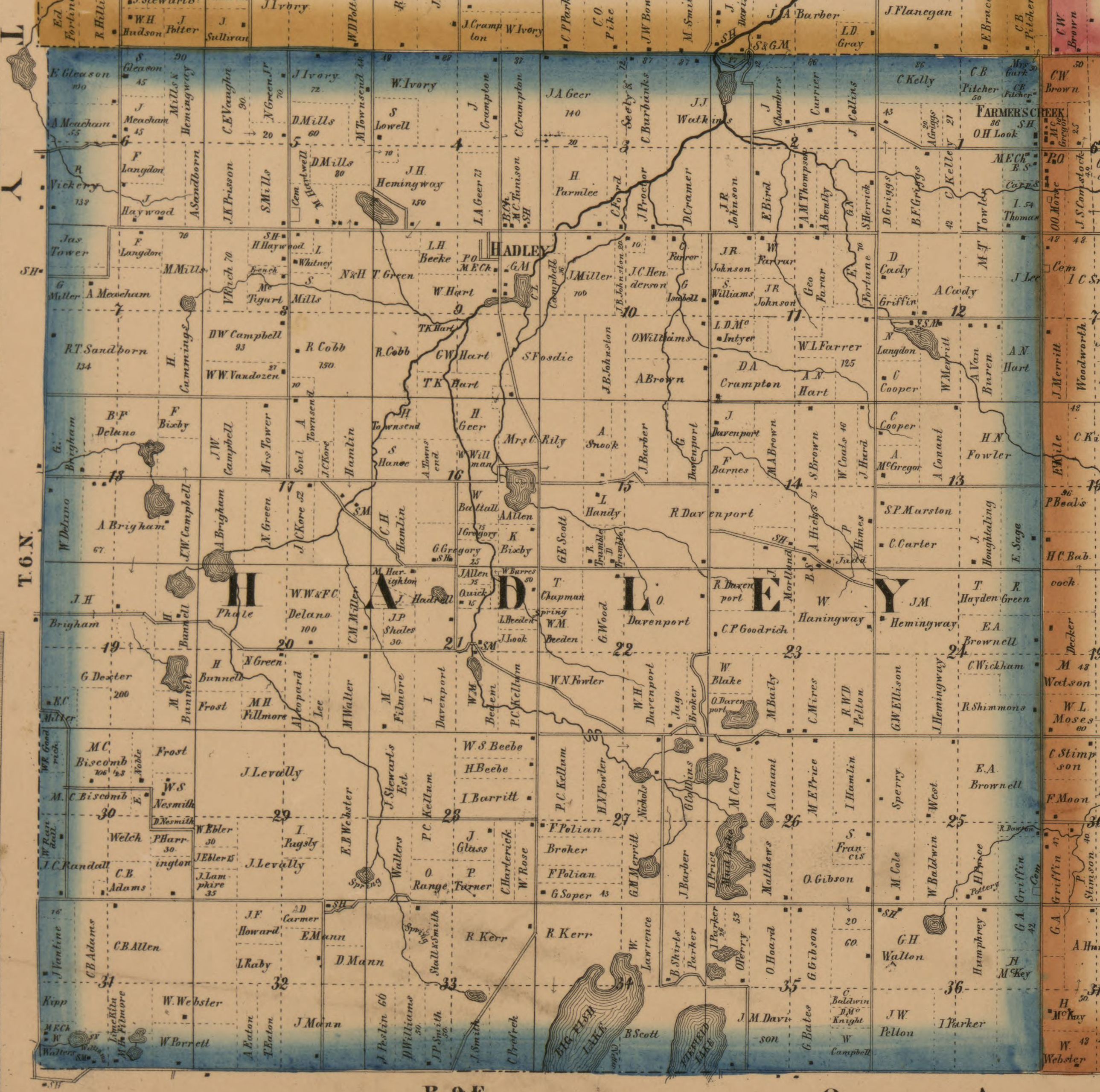
1863 map of Hadley Township (T6N-R9E) cropped from the 1863
map of Lapeer County.
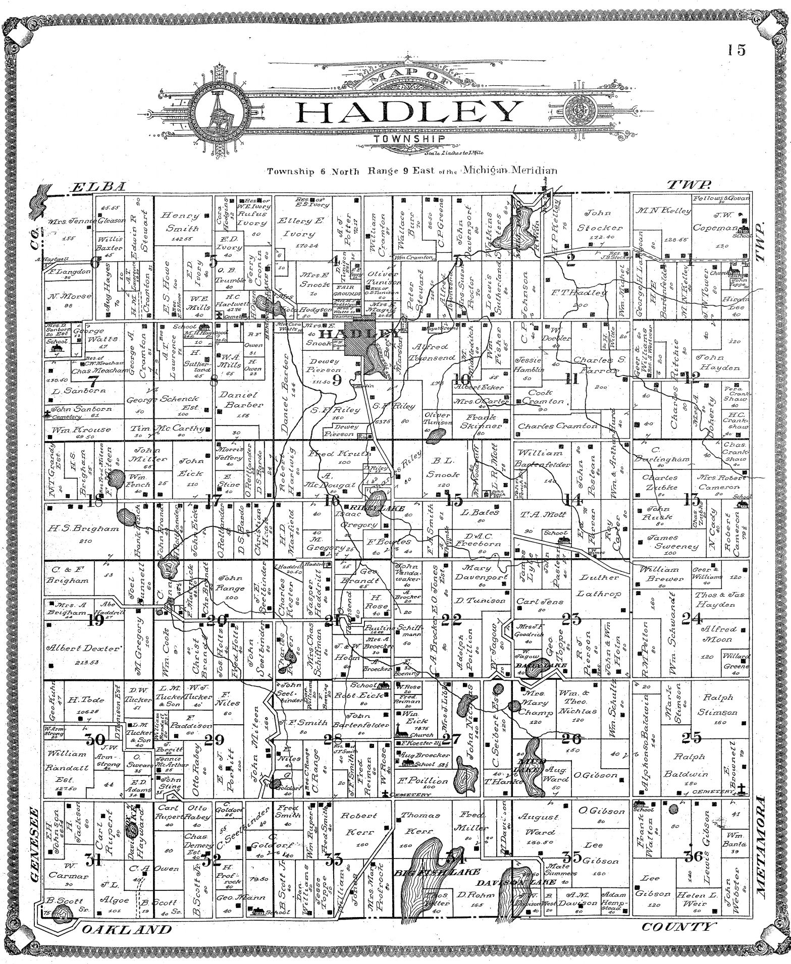
1906 map of Hadley Township (T6N-R9E) from the 1906
Atlas of Lapeer County. | |
Village of Hadley 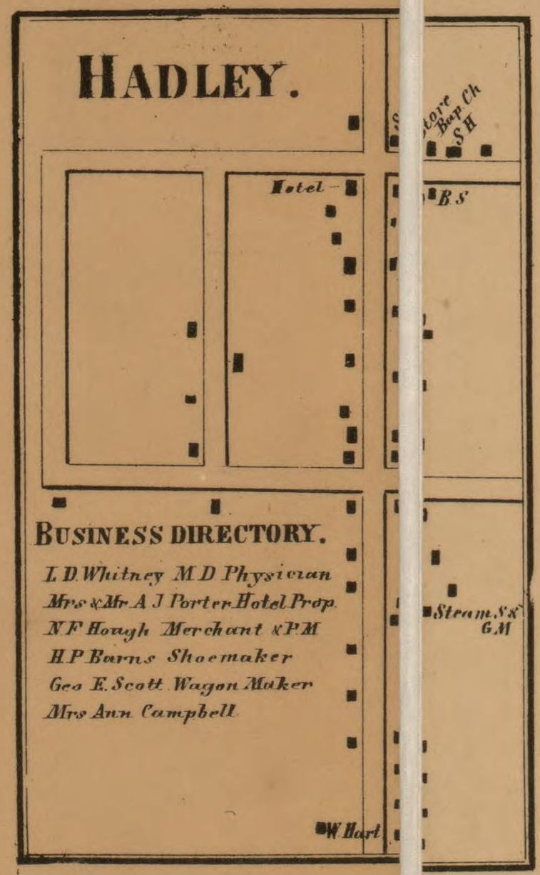
1863 map of the village of Hadley from the 1863 Map of Lapeer County.
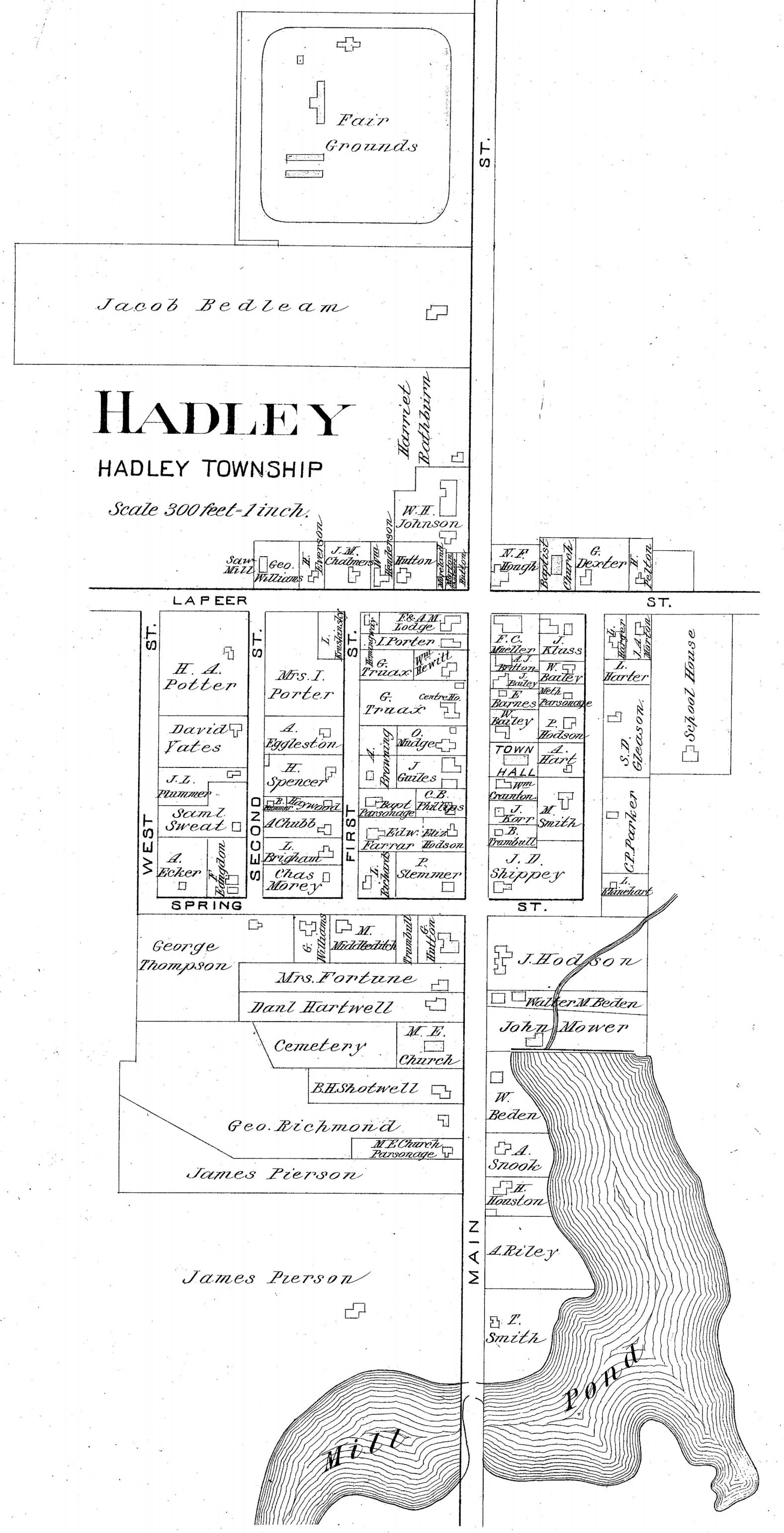
1893 map of the village of Hadley from the 1893 Atlas of Lapeer County. 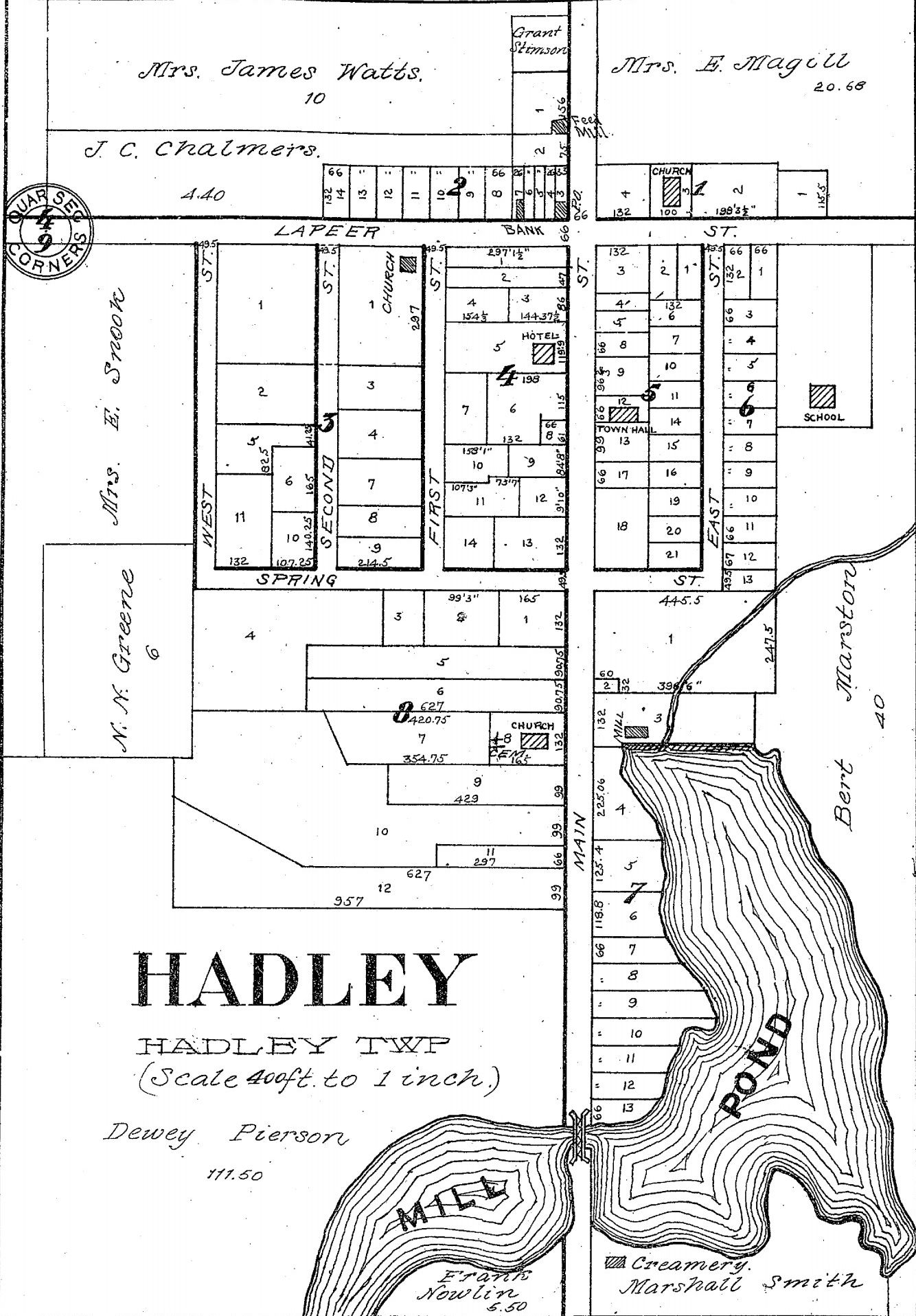
1906 map of the village of Hadley from the 1906 Atlas of Lapeer County. | |
|
Cemeteries in Hadley Township Greenwood Cemetery, also known as Green Corners Cemetery, is on the NE corner of Green Corners Road and Pratt Road, in Section 5, a mile west of the village of Hadley, in the northwest corner of Hadley Township. There are 1,716 memorials on Find A Grave, with 90% photographed. The Tombstone Transcription Project also has 44 images from this cemetery. (Note: There is another Greenwood Cemetery in North Branch Township, Lapeer County.) The Hadley Community Church Cemetery is next to the church, on the south side of Hadley village, Section 9. Find A Grave has 458 memorials for this cemetery, with 69% photographed, and the Tombstone Transcription Project has 91 images. The earliest graves are dated 1837, and there are only a few after 1930. Rural Vale Cemetery, abandoned and possibly moved, was located in the SW corner of Section 25, on Baldwin Road, between Brauer and Brocker. Find A Grave has 8 memorials with 5 photographed. The graves date from 1854 to 1866. Surnames are BALDWIN (1), DAWSON (2), PRICE (4) and WRIGHT (1). The Sanborn Cemetery is in Section 7, on the western edge of Hadley Township. Find A Grave has 29 memorials, of which 19 have gravestone photos, and 17 have the surname SANBORN. The dates range from 1842 to 1957. The South Hadley Cemetery, also known as Christ Lutheran Cemetery, lies in the SE corner of Section 28, about 1/2 mile NW of Big Fish Lake. Find A Grave has 227 memorials, with 90% photographed. The earliest grave is from 1877, but many are after 2000. | |
|
Main resource: [HRP] History of Lapeer County, Michigan : with illustrations and biographical sketches of some of its prominent men and pioneers (1884) by H. R. Page Names of property owners can be seen on the 1863, 1874, 1893, 1906 and 1921 plat maps. See the Maps page for links to these. Back to History of Each Township and Village in Lapeer County, MI |
|
This page was last revised 1 Oct 2025.
Lapeer County MIGenWeb contents have been willed to MIGenWeb. |