

KALAMAZOO COUNTY, MI
GENEALOGY & LOCAL HISTORY
COUNTY HISTORY PAGE 1
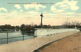 The Gull Street Bridge, site of earlier ferries and bridges that provided a means of crossing the Kalamazoo River into the heart of the county. |
| Origins Of Kalmazoo County And City | Kalmazoo Centennial History |
| Kalamazoo River | St. Joseph River Watershed |
ORIGINS OF KALAMAZOO COUNTY AND CITY
|
After the Revolution, Michigan and the
rest of the upper great lakes region were organized by the Northwest Ordinance of 1787. 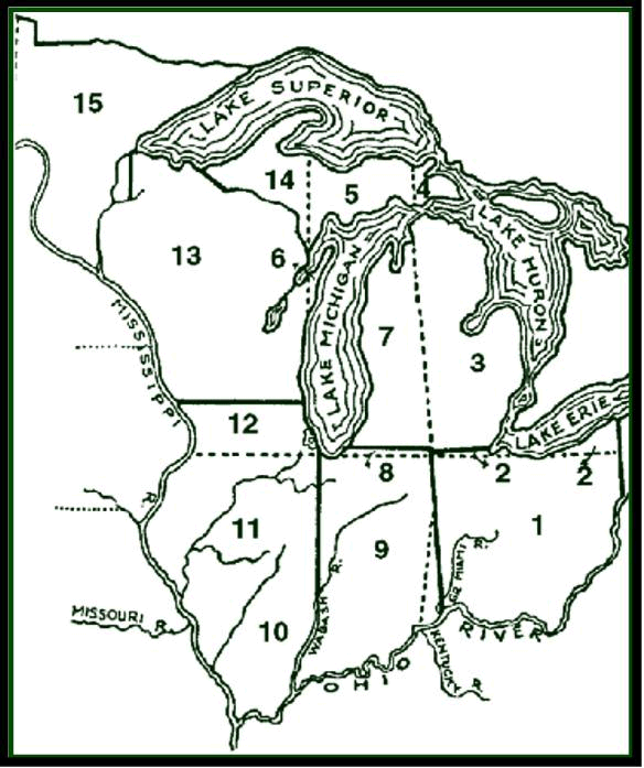
Kalamazoo County was organized by an act of the Territorial Legislature and approved by the Governor on July 30, 1830. The town of Bronson, subsequently Kalamazoo, named for the village's founder, Titus Bronson, was designated the county seat in 1831. See the Chronology of Township, Village and City Formation page. |
 |
The village was renamed Kalamazoo by legislative act in 1836. The county's name is said to be derived from the word "Kikalamazoo" which means "the mirage of the reflecting river."
Identical historical markers placed in expressway rest areas near county borders, with the words shown below, summarize the settlement and history of the Kalamazoo region:
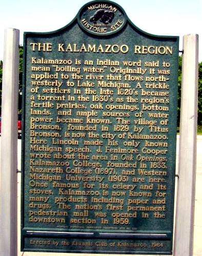 KALAMAZOO IS AN INDIAN WORD SAID TO MEAN "BOILING WATER." ORIGINALLY IT WAS APPLIED TO THE RIVER THAT FLOWS NORTH-WESTERLY TO LAKE MICHIGAN. A TRICKLE OF SETTLERS IN THE LATE 1820'S BECAME A TORRENT IN THE 1830'S AS THE REGIONS FERTILE PRAIRIES, OAK OPENINGS, BOTTOM LANDS, AND AMPLE SOURCES OF WATER POWER BECAME KNOWN. THE VILLAGE OF BRONSON, FOUNDED IN 1829 BY TITUS BRONSON, IS NOW THE CITY OF KALAMAZOO. HERE LINCOLN MADE HIS ONLY KNOWN MICHIGAN SPEECH. J. FENNIMORE COOPER WROTE ABOUT THE AREA IN OAK OPENINGS. KALAMAZOO COLLEGE FOUNDED IN 1833, NAZARETH COLLEGE (1897), AND WESTERN MICHIGAN UNIVERSITY (1903) ARE HERE. ONCE FAMOUS FOR ITS CELERY AND STOVES, KALAMAZOO IS NOW KNOWN FOR MANY PRODUCTS INCLUDING PAPER AND DRUGS. THE NATION'S FIRST PERMANENT PEDESTRIAN MALL WAS OPENED IN THE DOWNTOWN SECTION IN 1959. |
back to the topics heading list
There were probably
two traders here (Kalamazoo) in the winter of 1795 named Pepan and
Burrell. During the War of 1812 the British established a smithy
(blacksmith) here to mend guns for the Indians on the present
aviation field (Kalamazoo Airport, once the site of the large Indian
camp known as 'Indian Fields') was a prison camp (prisoner of war
camp) and the village where the women and children lived while the
braves were away fighting for the British.
But the first
permanent trading post was to come later. Here is what Rix
Robinson said about it in 1866. 'The little trading hut at Kalamazoo
was on the north side of the river and was erected by an old
Frenchman named Numaiville in the fall of 1823. He traded there in
the winter of 1824 and then returned to Mackinac. In the fall of
1824 I erected more substantial buildings and employed the same old
clerk... I continued to occupy the place by different clerks until
1837 when I closed up my Indian trade.'
The first to erect a cabin on the present site of Kalamazoo (city, not the county) was Titus Bronson, a native of Connecticut, and a hardy pioneer, who arrived in June, 1829. This was soon after Orange Risdom, deputy U.S. surveyor, had finished platting into sections the Match-E-Be-Nash-E-Wish Indian reservation. Bronson built a cabin of tamarack poles and grass, 12 feet wide and 14 feet long, on Kalamazoo Avenue west of Westnedge Avenue near Arcadia Creek, which then flowed about 200 feet north of the present artificial channel."
 |
 |
|
|
|
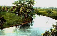
The Kalamazoo River was key to development of Kalamazoo County and was described as follows in the 1854 Michigan Gazetteer:
|
"KALAMAZOO river, of Michigan, rises in Hillsdale county, in the S. part of the state, and flowing in a W. N.W. direction, enters Lake Michigan in Allegan county, 29 miles S. from Grand river. The whole length is nearly 200 miles, and the width near its mouth is between 300 and 400 feet. It is navigable for boats of 50 tons in all stages to Allegan, a distance of 38 miles. The region through which it flows is nearly level, and the soil is generally fertile." |
| RIPARIAN
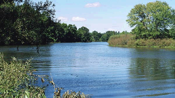
ECOSYSTEM: Molded by the melting of the mile-high glaciers the Kalamazoo River Valley comprises one of Michigan's most significant drainage basins. The river originates in Hillsdale County and from the junction of its two main branches near Albion to its mouth on Lake Michigan it drops 352 feet while meandering 138 miles through Calhoun, Kalamazoo and Allegan Counties. |
|
KALAMAZOO RIVER LEGENDS Know variously on early maps as the Muramek, Maramee and Reccanamazoo, by the early 19th century the river came to be called Kalamazoo, a derivation of an Algonquian phrase meaning "boiling pot." Many fanciful interpretations of its origins have been suggested, but most likely the term refers to water swirling at rapids or morning mist rising steam-like from its surface |
| KALAMAZOO RIVER ECONOMIC IMPORTANCE A watery high of the Potawatomi, the Kalamazoo River beckoned to pioneers who soon dotted its length with frontier settlements. Its waters powered early industry and floated rafts of flour and logs to markets. Many generations fished its depths, harvested mussels that lined its bottom and enjoyed its scenic grandeur. By the 1930s eleven electric-generating dams harnessed its flow. |
| KALAMAZOO RIVER ENVIRONMENTAL
IMPORTANCE American Indians harvested vast fields of wild rice near the mouth of the Kalamazoo and drank its crystal waters. But by the mid 1800s the river served as a drain for industrial pollutants and urban sewage. Industrial contaminates emerged as a public concern in 1971 and a citizen-government partnership began working to return the river to its natural state. |
back to the topics heading list
Kalamazoo County crosses two watersheds, the Kalamazoo River and St. Joseph River watersheds. Although the St. Joseph River itself does not flow through the county, it drains the southern half of it.
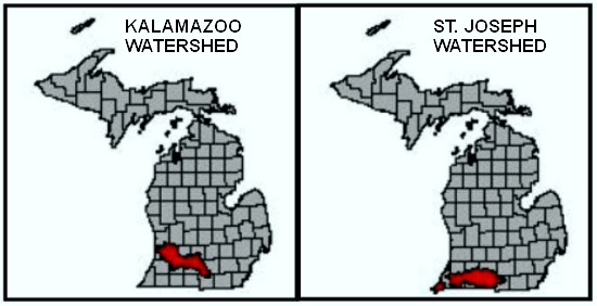
Kalamazoo County & St. Joseph County Watershed Map |
The maps are based on maps from the Michigan Center for Geographic Information for the Kalamazoo and St. Joseph watersheds. The St. Joseph map only shows the Michigan portion of the St. Joseph water shed; the St. Joseph river flows into northern Indiana.
The St. Joseph watershed includes the lakes in city of Portage and much of the area south of Centre Street. Since prehistoric time people and trade have regularly crossed the two watersheds. Portage Creek and the Portage Trail, the Indian trail that became Portage Road, facilitated the connections between the watersheds. In 1831 Titus Bronson directed Stephen Vickery, after whom the village of Vicksburg is named, to the Portage Trail. Vickery followed the trail south into the county and dammed Portage Creek. Then he used some small millstones he had brought from Indiana to creek to build the first mill in the county - see Vicksburg MI History Site
See the Milham Park and Portage Creek Bicentennial Park pages for views of Portage Creek.
The St. Joseph watershed, traditional home of the Pottawatomie, has played an important part in the history of Kalamazoo County and Southwestern Michigan.
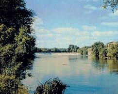 St. Joseph River, Berrien County |
The following is based on a history of the St. Joseph river by By Bob Owens & Scott Null written for the Friends of the St. Joseph River
"The St. Joseph River like other geographic features in southwest Michigan was formed as the glaciers retreated 8000 years ago. Evidence suggests the first people to visit the region were small bands of hunters. Settlements were established along the St. Joseph from 4000 to 2000 BC. About 2,000 BC. people known as the mound builders came to southwest Michigan from the central Mississippi region. Many mounds existed throughout the Saint Joseph River valley and the artifacts found in the mounds suggest that these people traveled and traded extensively throughout this continent.
The Hopewell people arrived about 500 BC. It is not certain if this group of people was an outgrowth of the earlier mound builders. Hopewells also built mounds, however, the Hopewellean mounds were usually formed in effigy of different animals. The Hopewell people appear to have disappeared around 900 AD perhaps as a result of the migration of another people, the Algonquins. The major Algonquin groups were (1) the tribe that became known as the Potowatomi who resided to the north of present day South Haven and (2) the Miami tribe who occupied the southern part of Lake Michigan and most of the Saint Joseph River Valley.
The Miami lands were host to a hundred and fifty miles of a heavily traveled cross continental trail that later came to be known as the Sauk Trail (presently US-l2). The Miami tribe occupied land as far west as what is now Gary, Indiana. The Miamis called the St. Joseph River, Sauk-Wauk-Sil-Buck.
In 1610, under Samuel de Champlain the French began fur trade with the Iroquois. As the Iroquois exhausted the game in their traditional hunting areas, they reached into Michigan driving out many of the Algonquin peoples who retreated to Wisconsin and western Illinois.
The Iroquois called the St. Joseph, the River of The Illinois (after 1630) and called Lake Michigan, the Lake of The Illinois, perhaps because the first Algonquian tribe that they encountered after crossing the river was the Illinois tribe who inhabited the southwestern shore of Lake Michigan.
Some of the Miami tribe began to return to the Saint Joseph River Valley, but met determined opposition from the Iroquois.
In the fall of 1654, Medard Chouart Des Groseilliers crossed the lower part of Michigan from east to west. He was accompanied by an unknown French companion and a few Huron guides. These two Frenchmen paddled their small gondolas (birch bark canoes) down most of the length of the Saint Joseph River. Des Groseilliers did not give a name to the river but , he did record the Miami tribe as dwelling along the south east shore of the big lake. The tribe called the lake "Michigami" which was the Algonquian name for Lake Michigan. In all probability, Des Groseilliers referred to the Saint Joseph River by the Miami name Sauk-Wauk-Sil-Buck.
Claude Allouez, a Jesuit missionary, arrived in the Green Bay area in 1666. He named the great lake "Lake Saint Joseph" upon first seeing it on the date of the Catholic Feast Day of Saint Joseph.
In the spring of 1672, Rene-Robert Cavalier De La Salle passed up the Kankakee River, across the Grand Portage, and down the Saint Joseph River in his quest to find the easiest route between Quebec and the Mississippi's mouth. He found only Miami Indians along the banks of the Saint Joseph River; he named the river, The River of the Miami's.
Claude Allouez founded a mission at the junction of our river and the great transcontinental trail. He had followed an exodus of Algonquian people returning to southwest Michigan. This area came to be called Parkovash by the French because of the great herds of buffalo that grazed here. At this time Claud Allouez named the river The River Saint Joseph because it was the largest river that he knew to drain into his "Lake Saint Joseph".
La Salle returned to his River of the Miami's in 1679. La Salle made numerous trips up and down the river between the mouth and the Grand Portage during the following few years. He continued to use the name he had created for the stream.
The French built a fort on the west bank of the Saint Joseph River near present day Niles, Michigan in 1691. At about this time, more Potowatomi bands began migrating to the south of Lake Michigan from Green Bay. They found protection near the west bank of the Saint Joseph River where Fort Saint Joseph was garrisoned by their friends, the French. And, the Miami's occupied the east bank. The Fort offered the Potowatomi a refuge from the Iroquois incursions while opening up fur trade directly with the French. This trade arrangement was better for both the Miamis and Potowatomis because it eliminated the middle men who were previously the Ottawa and the Hurons. The Potowatomi name for the river was Sohg-Wah-Se-Pe, or Sagwa-Se-Pe which translated means "Mystery River".
The French withdrew the garrison from the fort at about the turn of the 18th century but, the mission stayed on as did the French trappers and traders, but a new calamity befell them.
The Fox and Sauk tribes started to make raids upon the fur stores of the Potowatomi and the French traders in 1701. This was the beginning of the Fox Wars. The year 1702 found the Fox allied with the Mascoutens fighting on behalf of the English against the Potowatomi who backed the French.
By 1722 the Fox had the fur trade in a shambles. The Potowatomi thoroughly defeated the Fox and made peace in 1730. The Potowatomi then acted as mediators between the French and the Fox until 1737 when the war diminished. Many of the Miami tribe had moved to the Detroit area to escape the Fox incursions during the 1720's. They returned to the Saint Joseph River Valley in the mid 1730's, but the Potowatomi forced the Miami tribe south to the Tippecanoe Valley around 1743.
In the 1820's and 30's, settlers, using the old Indian transcontinental trail, often encountered roaming Sauk. This old trail came to be called the Sauk Trail. Those settlers who squatted and bought land along the Saint Joseph River lived among the Potowatomi bands who were the last Indians as a group to occupy the Saint Joseph River Valley."
back to the topics heading list
All rights reserved.
This site
may be freely linked to but not duplicated
in any fashion without my consent.
The information on these pages is meant for personal
genealogical
research only and
is not for commercial use of any type.