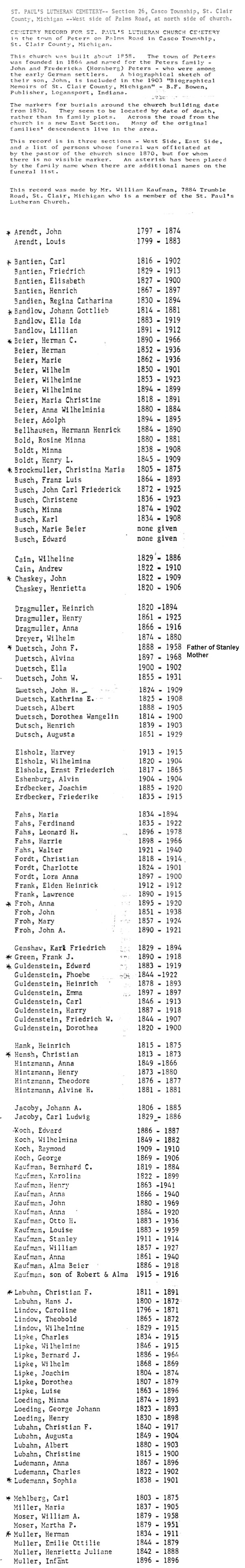
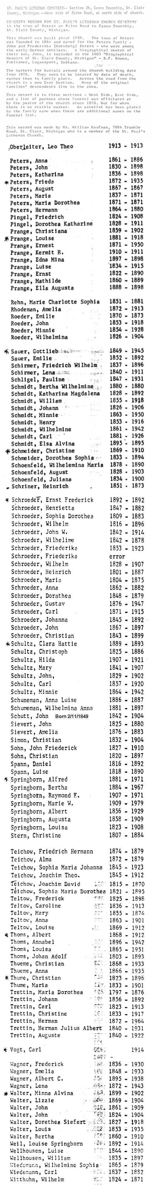
|
|
Scroll down for a list of
cemeteries in St. Clair County. There are images and searchable databases
of burial records for many of them, as well as some tombstone
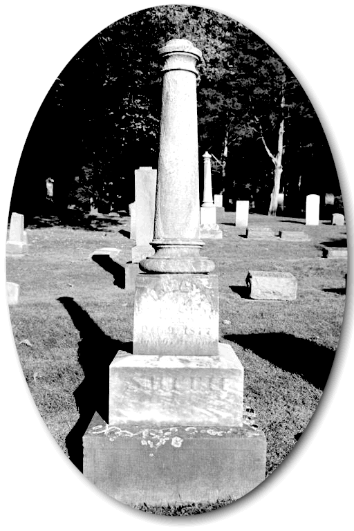
photographs on the
Tombstones
page. Where it's known, the address and telephone
number for the cemetery office or other organization responsible for the
cemetery is included. The location of each cemetery is based on information
obtained from DeLorme Software's Street Atlas USA program,
various telephone books and/or field verification. Another source is a map
printed in the 20 Aug 1995 issue of the Port Huron Times Herald,
which was based on information provided by the St. Clair County Family
History Group.
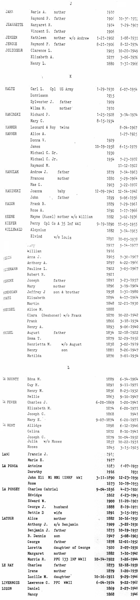
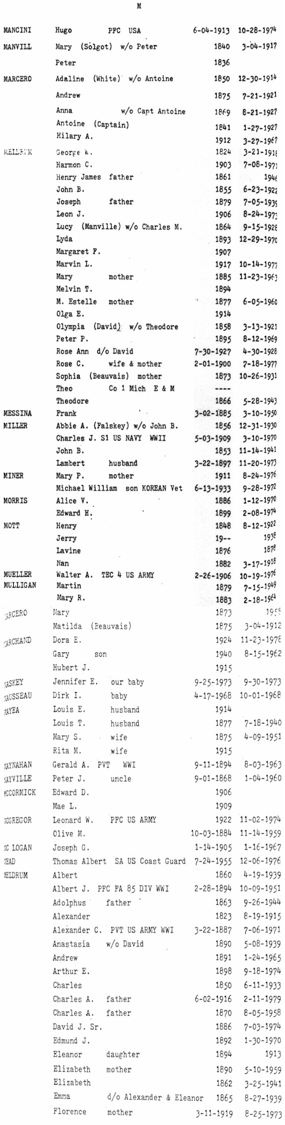
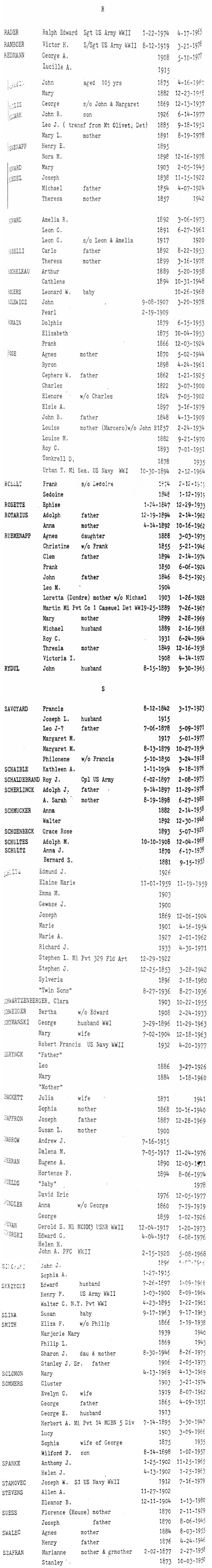
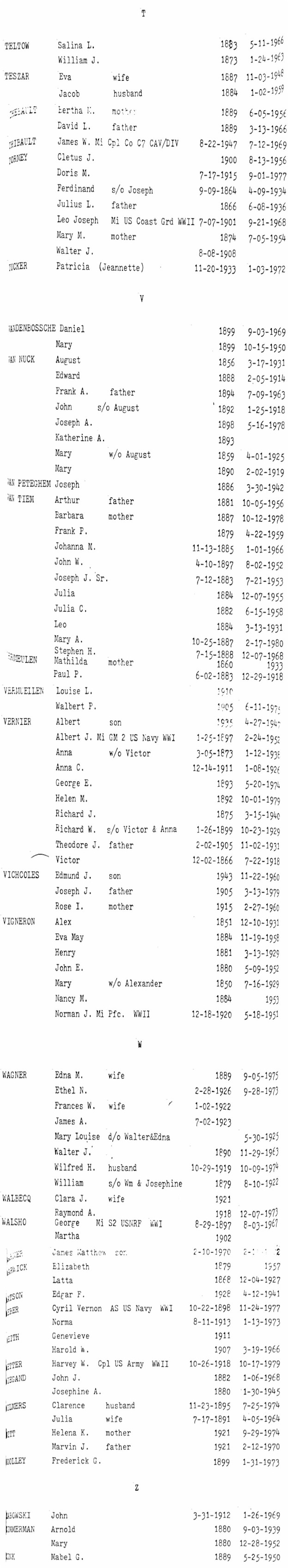
The "All Cemeteries Index" contains over
70,000 names and can take quite some time to load depending on your
internet speed.
You may wish to search by individual letter instead. All
cemeteries have not yet been transcribed, so if you don't find the name of
an ancestor you know is buried in St. Clair County, don't despair, simply
browse the individual cemetery records. Additionally, most of the
transcripts
cover only through 1982 or so.
Read the cemetery key
for important information about the source of materials and access to the
individual transcripts.
Once you have
located your ancestors in the searchable database you may then wish
to view the images for the specific cemeteries, below, as they
sometimes contain more information.
Credits
The images and transcripts exist thanks to the hard work
of Helen Whiting, Becky Thomas, Marge Owens and Lois Wedge in reading the
cemeteries many years ago; Pat Love for scanning the transcripts; Kay
Mitchell, Char Ellis, Lisa Masters and
others for typing the transcripts from the jpg images and other
sources; all of which permitted me to create the images and searchable electronic databases.
Without their many hours of volunteer labor,
this resource would not be available. Please send a mental
thank you to these ladies as you peruse these indices.
Many
thanks to Suzanne
Frantz, Melissa Lashbrook, Debbie Smith Russell, Gloria Reeves, Kathy
Hewelt, Char Ellis, Kathy Stocki, Andy Maturen, Sue Gleason, Jody
Riddick, Nancy Schoenherr, Debbie Laidler and Wayne Tibbetts
for adding and
field-verifying several cemeteries on this page.
|
|
All
Cemeteries Index |
Tombstone
Photographs
Many of the St. Clair County
cemetery transcripts are also now located at
Find-A-Grave, thanks to those who took the time to create the
transcripts and load them.
All Cemeteries Apha
Index:
A
| B |
C
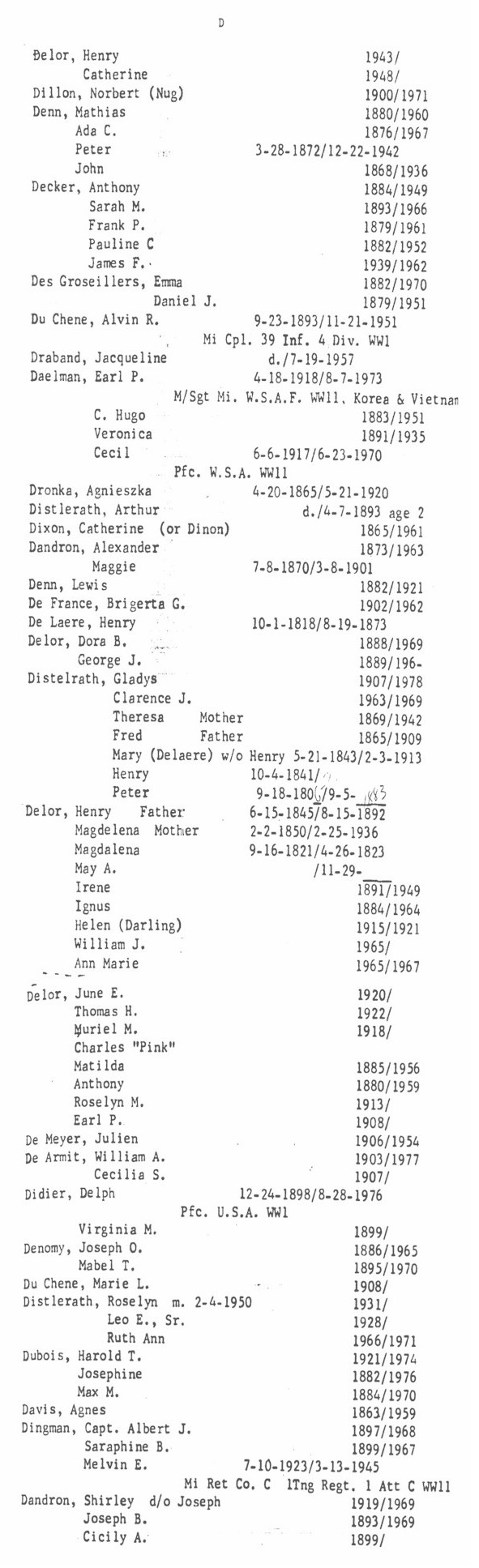
| D |
E
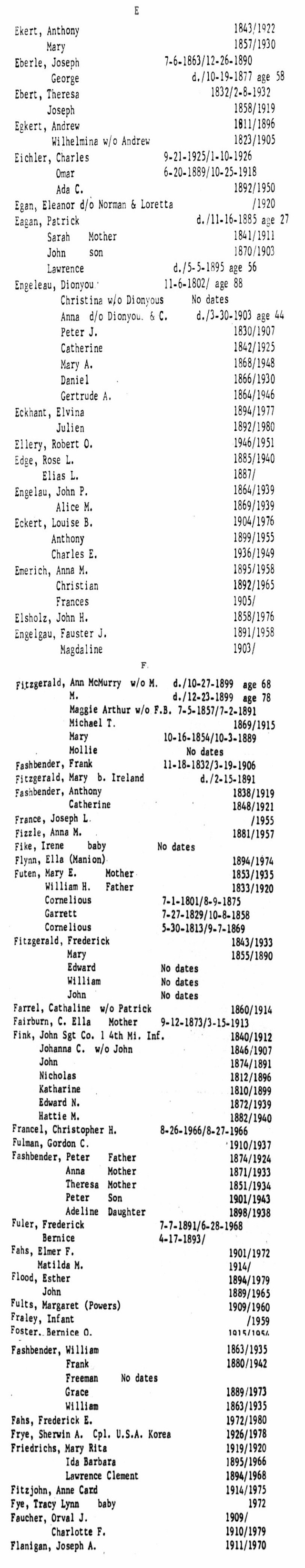
| F |
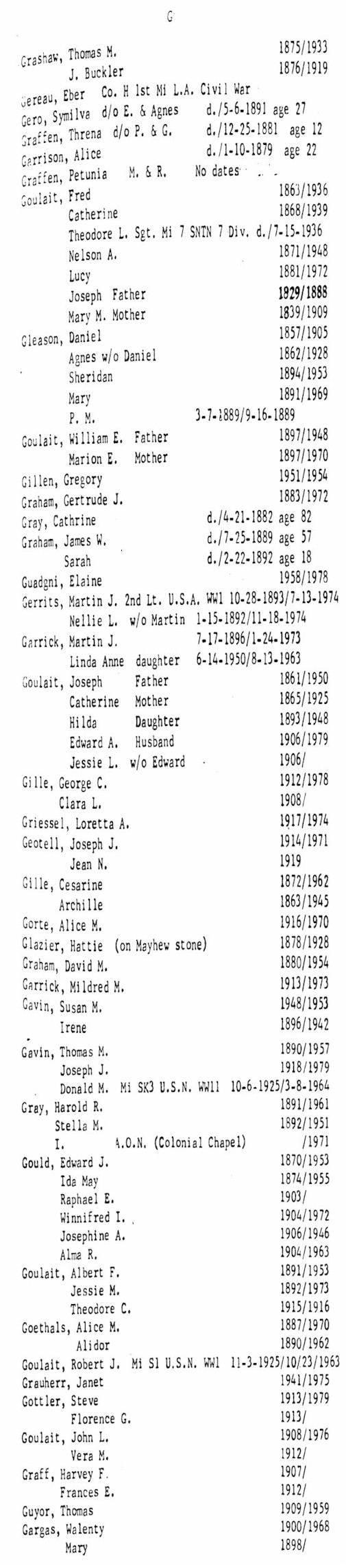
G
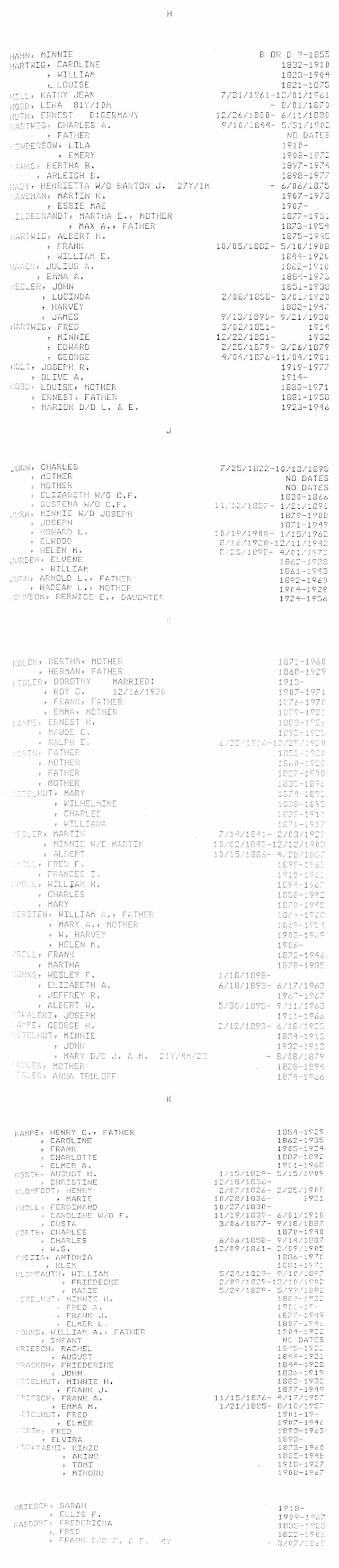
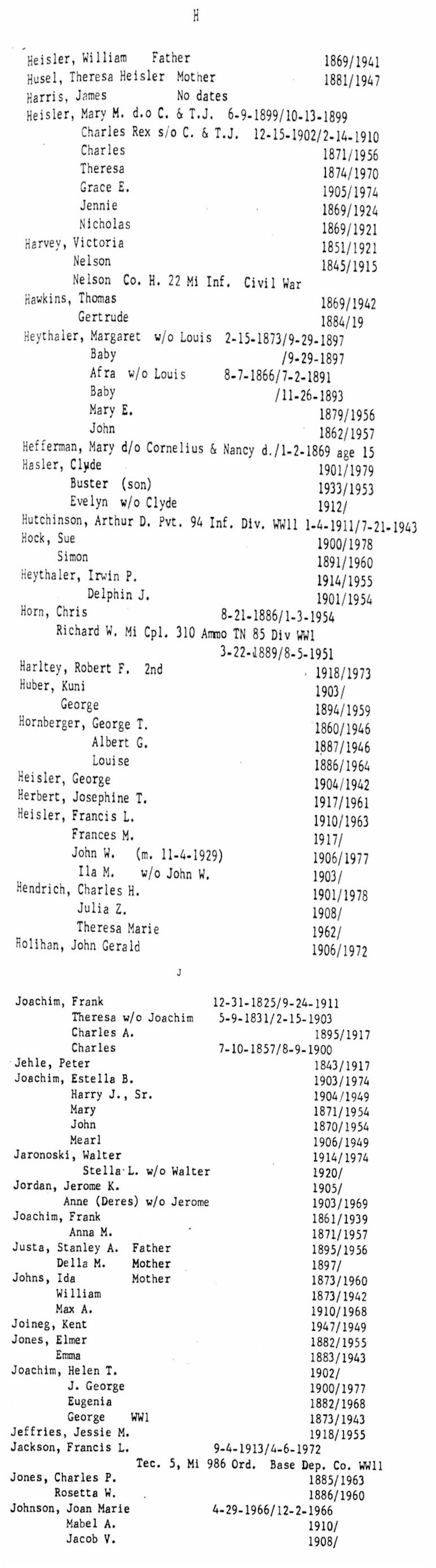
| H |
I
J |
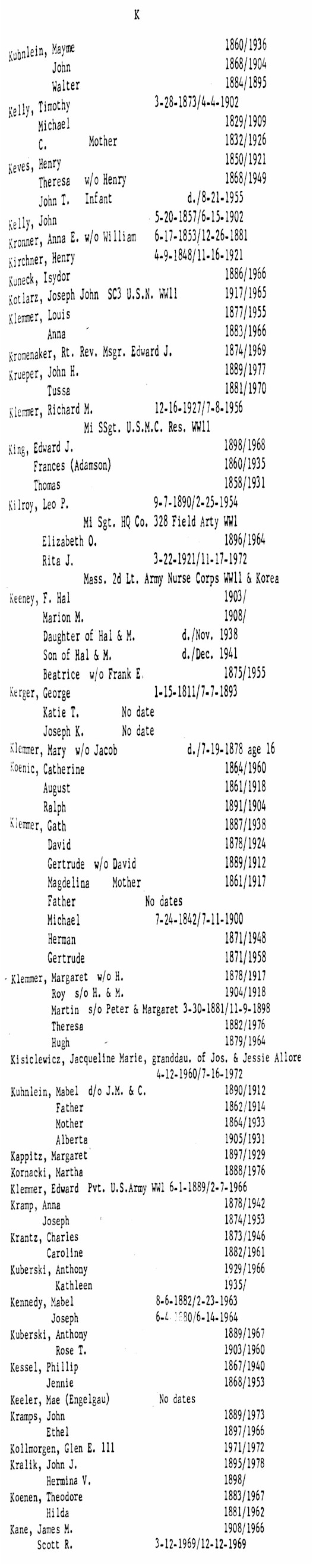
K
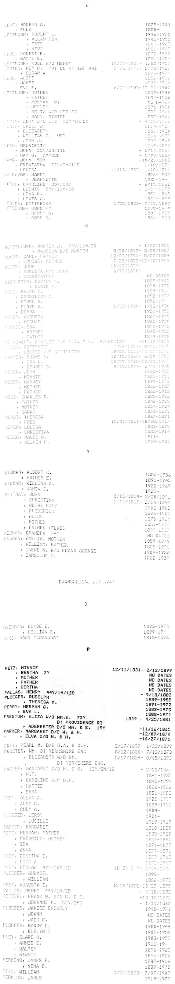
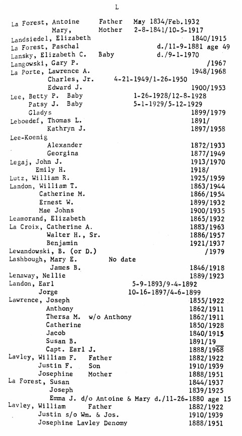
| L |
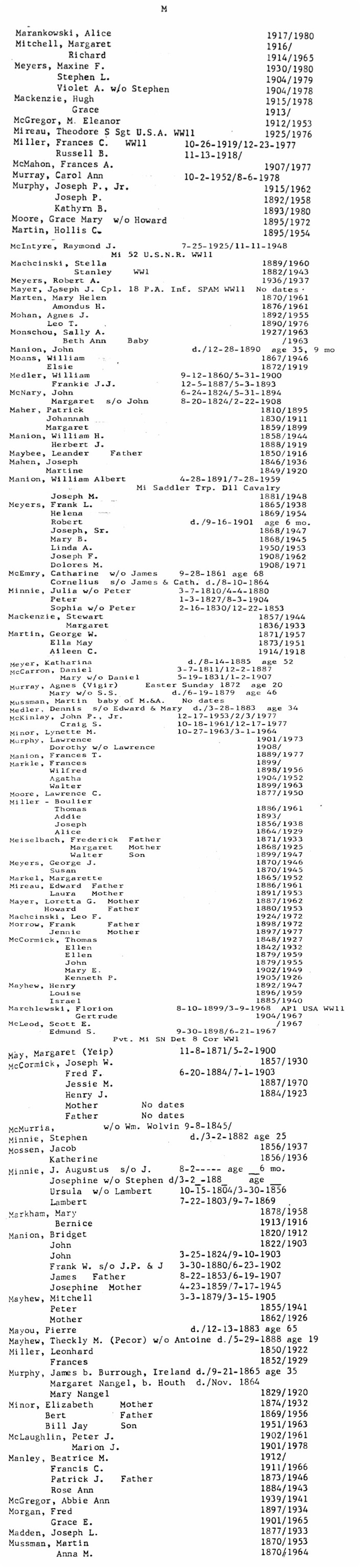
M
| N |
O
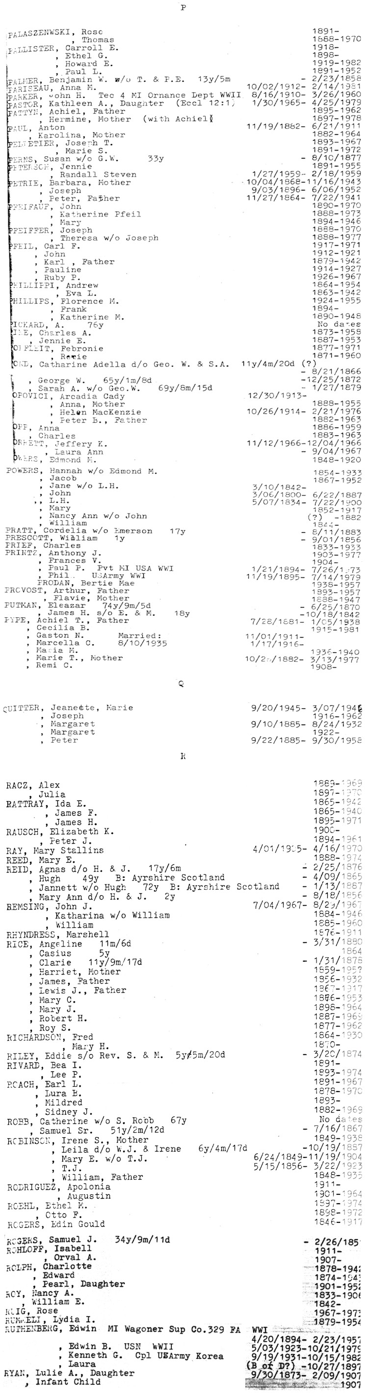
| P
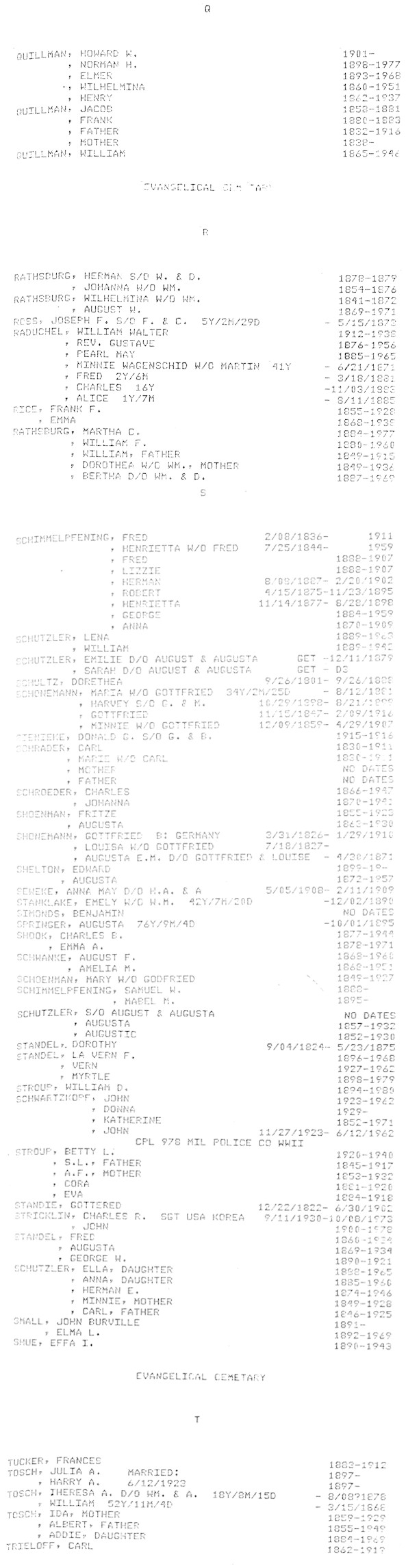
| Q |
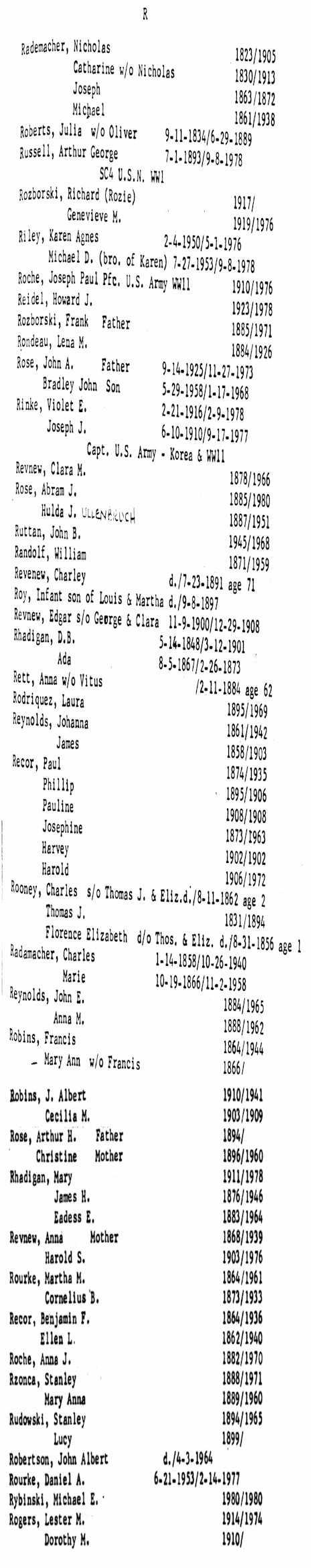
R
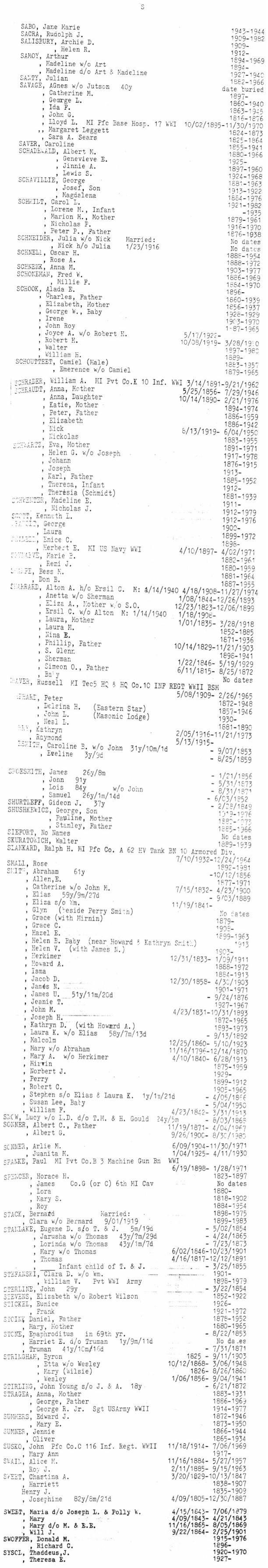
S |
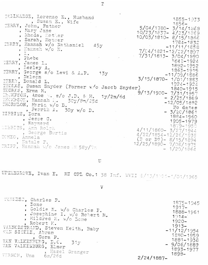
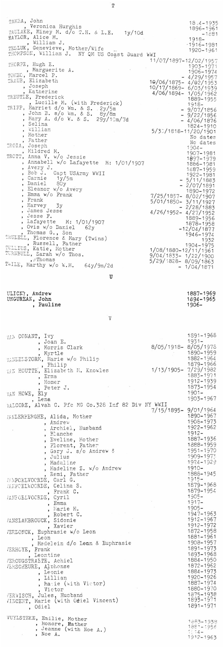
T
| U |
V
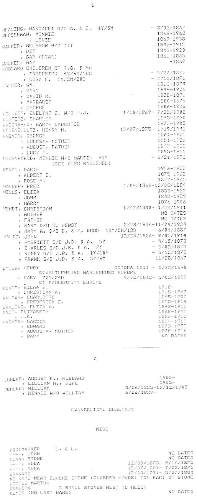
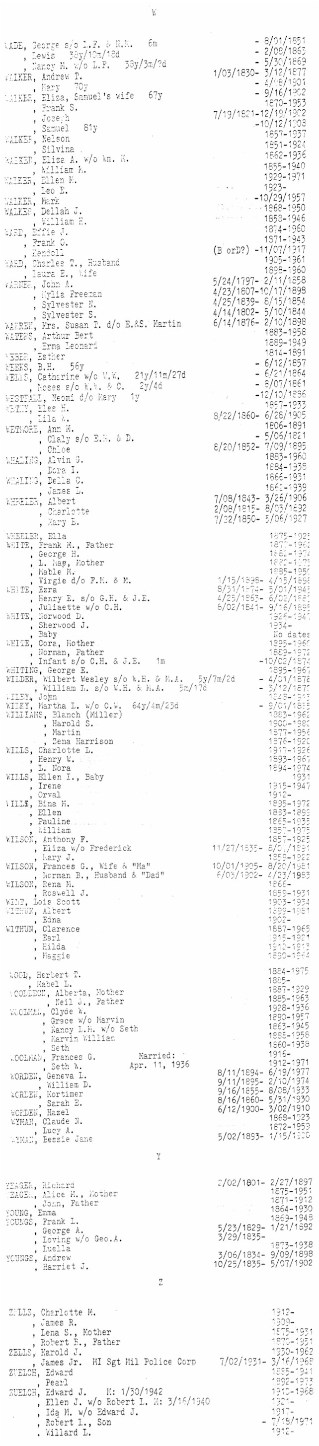
| W |
X
| Y |
Z
Casco Township
Cemeteries
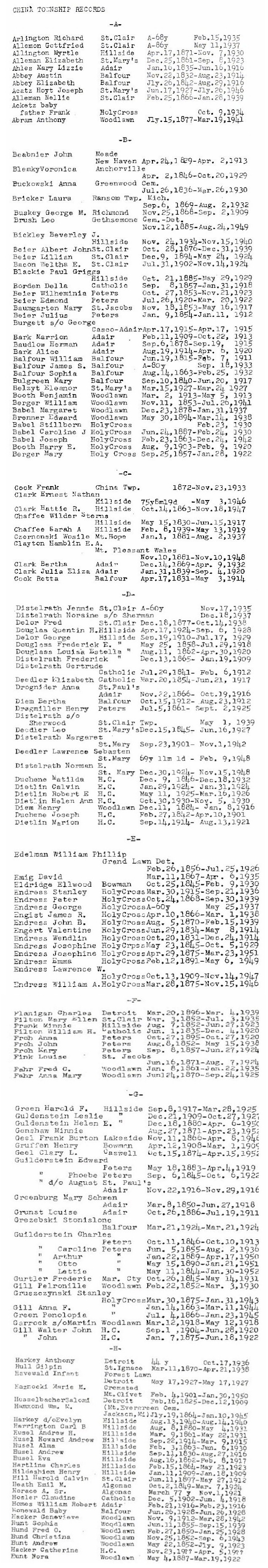
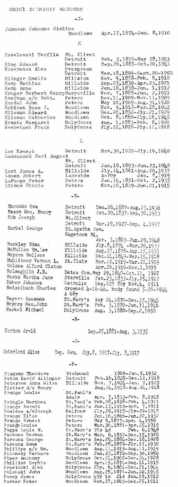
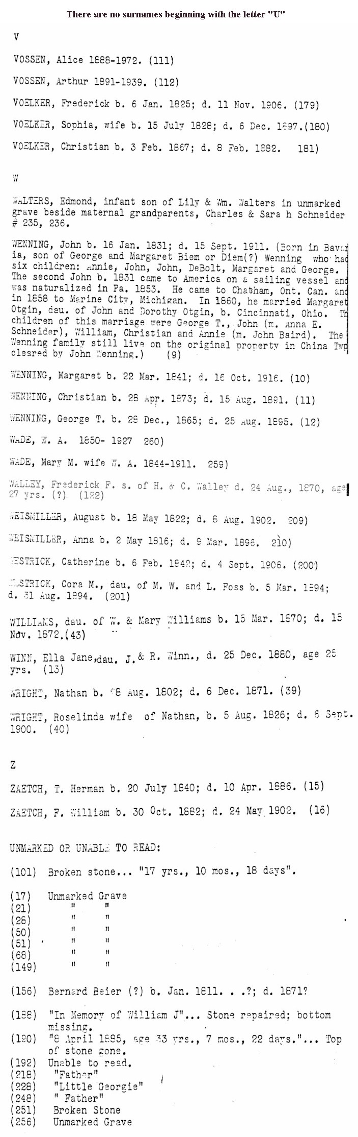
China
Township:
China Township residents' burials
are
not necessarily in St. Clair County or even
in Michigan.
A-I |
J-P |
Q-Z | Database
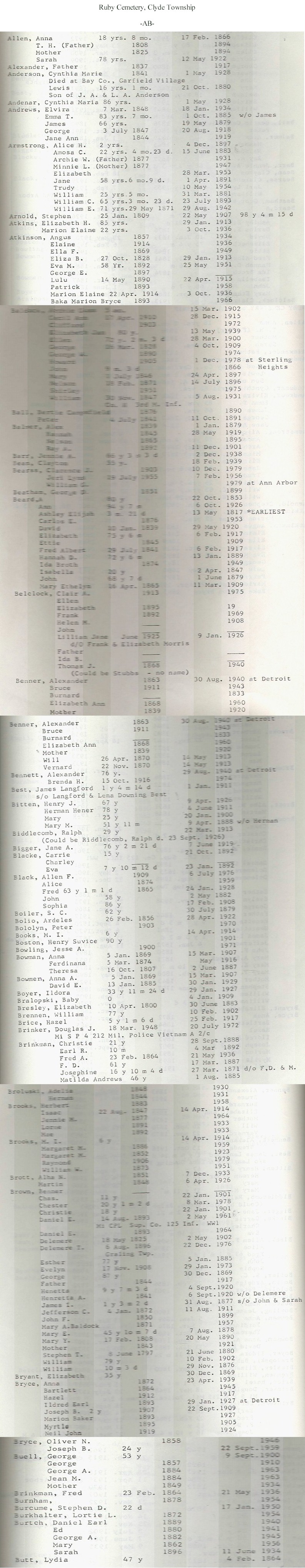
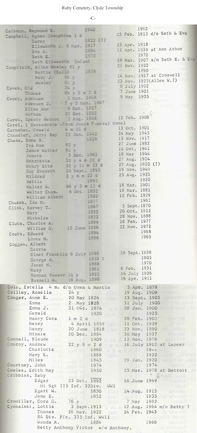
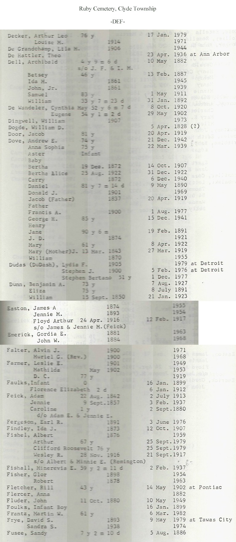
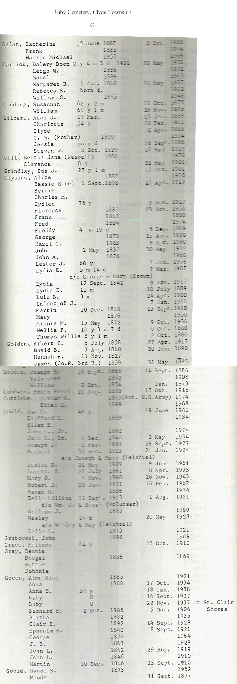
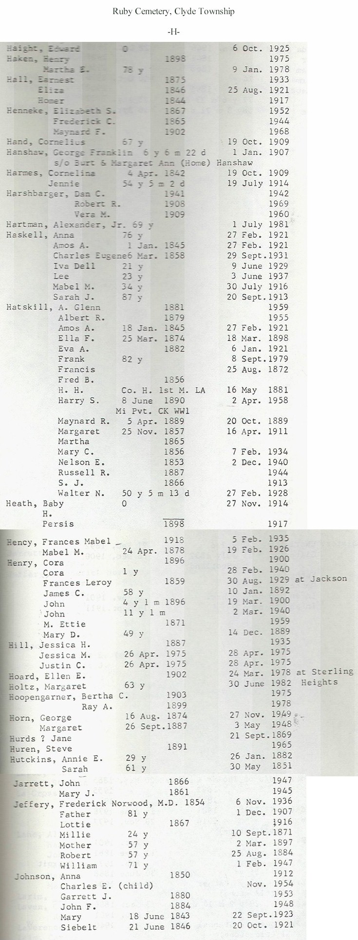
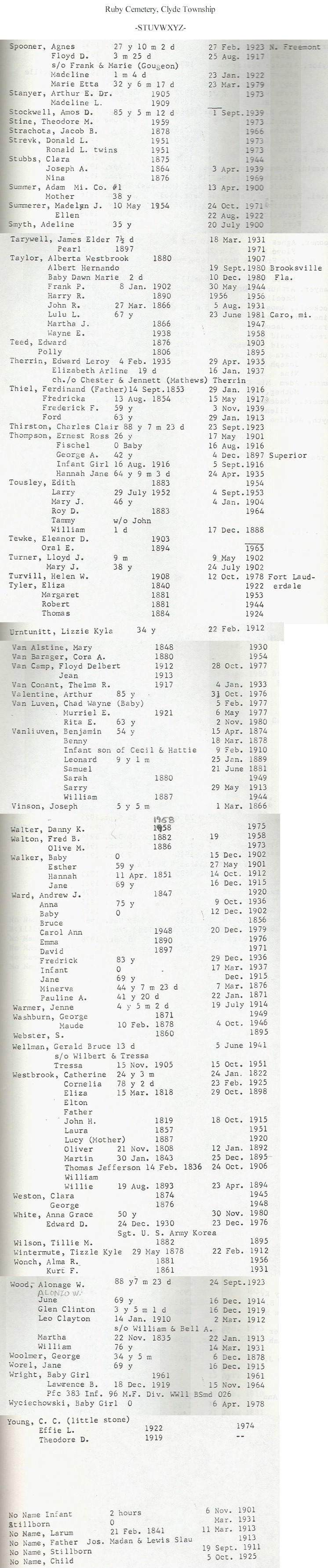
Clyde Township Cemeteries
Columbus Township Cemeteries
Cottrellville Township Cemeteries
East China Township
Cemeteries
East & West Berlin Township Cemeteries
East & West Berlin Cross Reference
Fort Gratiot Township Cemetery Records
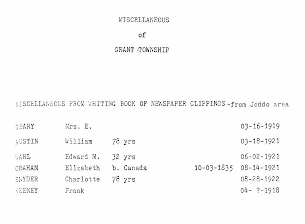
Grant Township: Miscellaneous from newspaper clippings - Jeddo area.
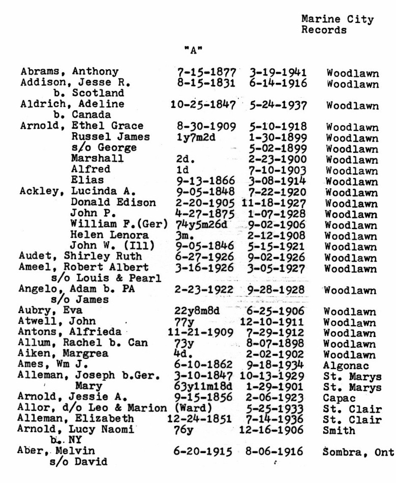
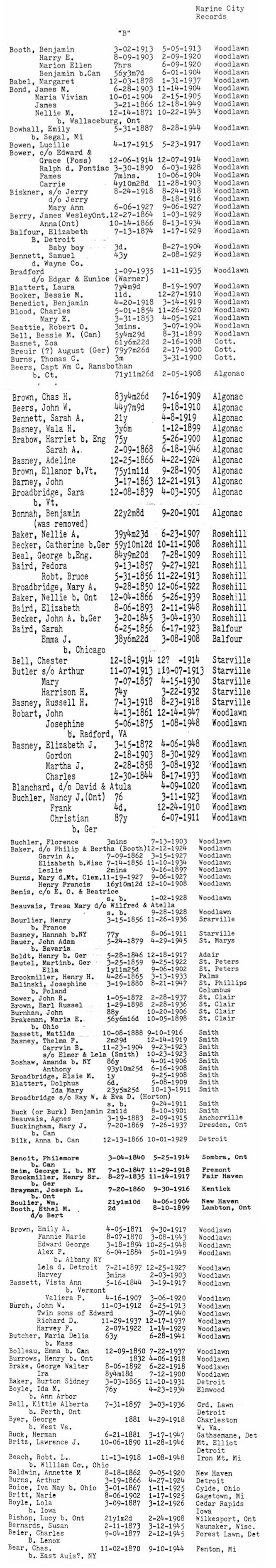
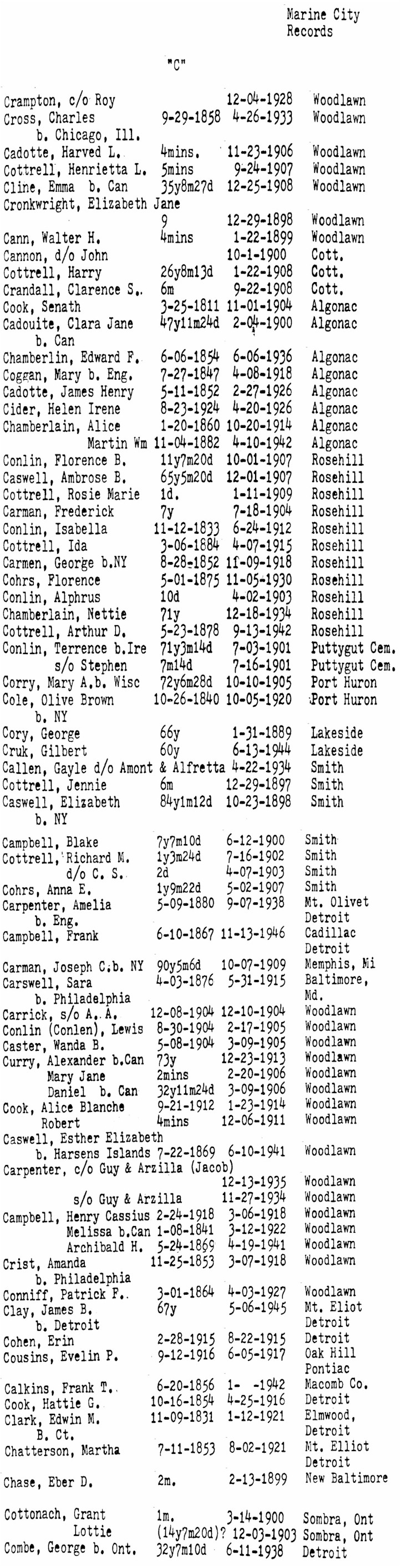
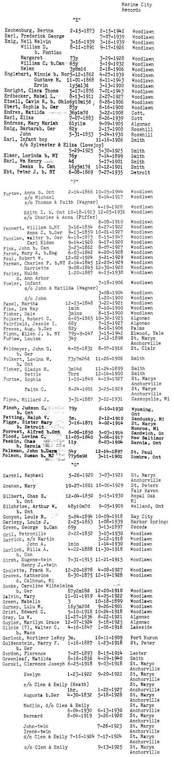
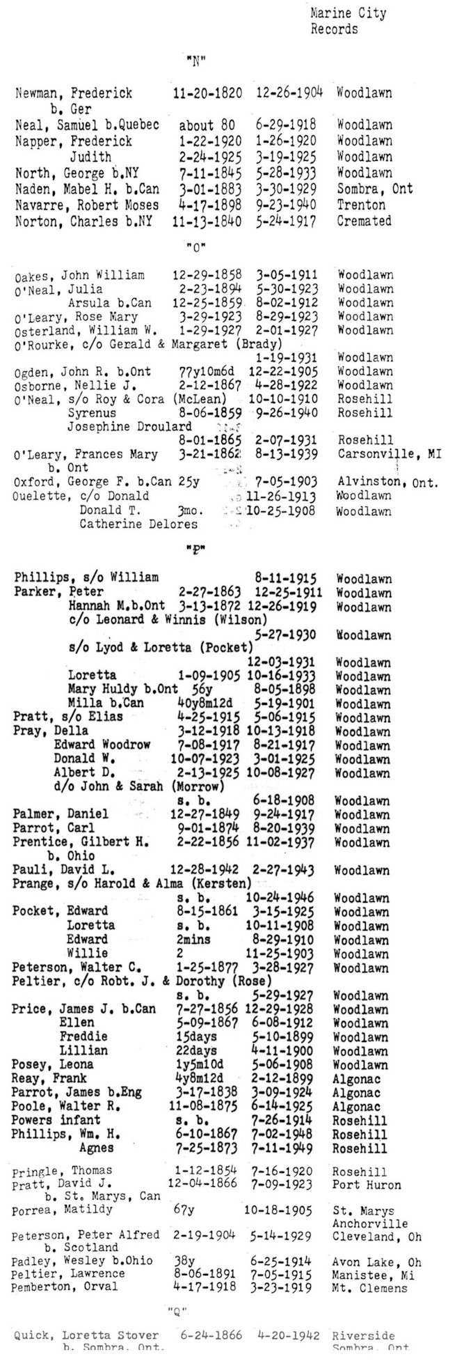
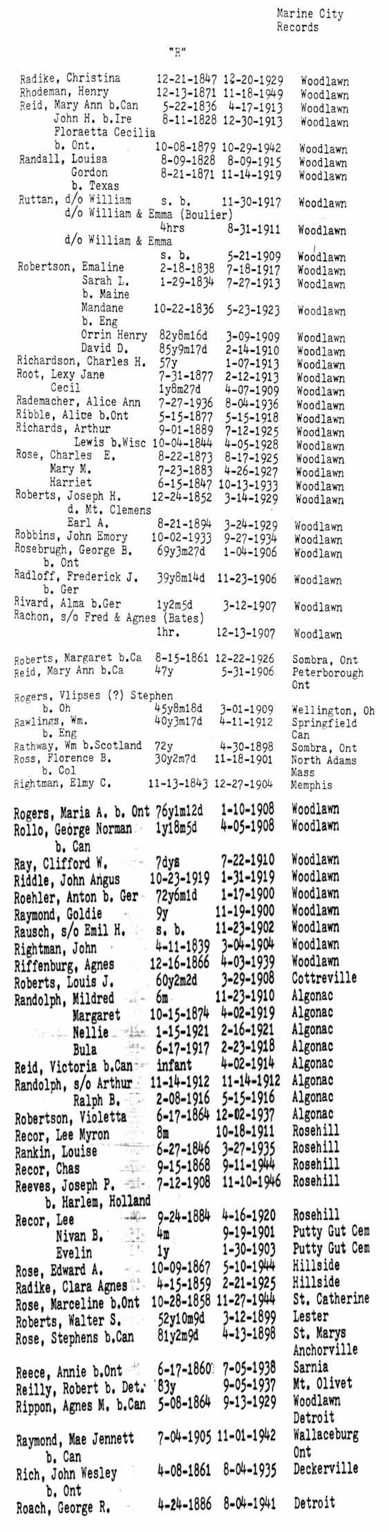
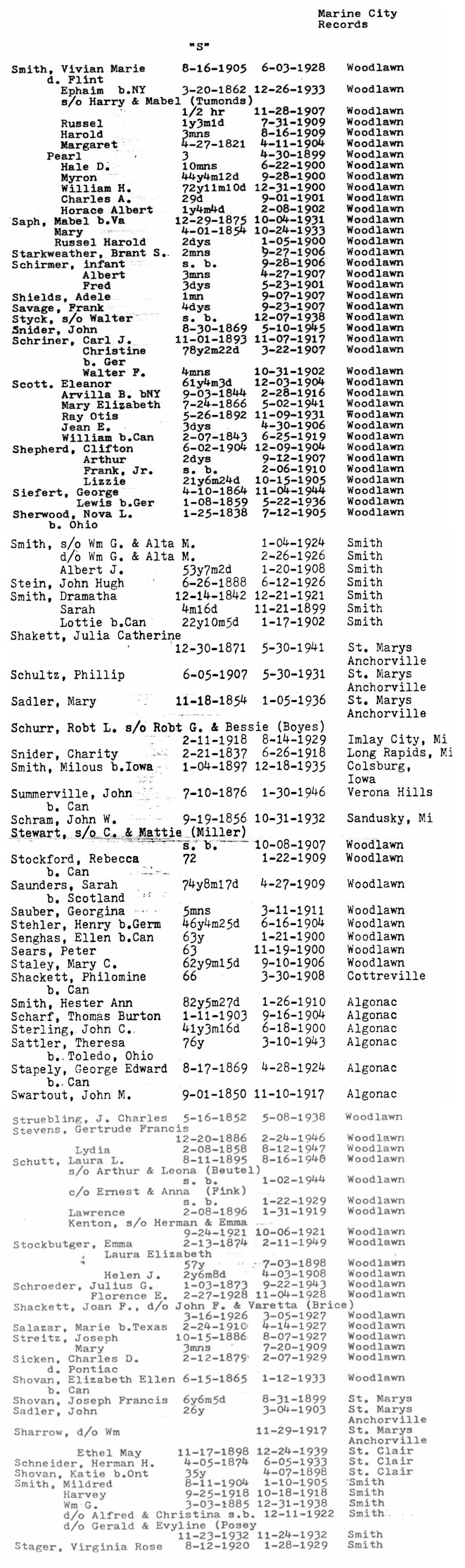
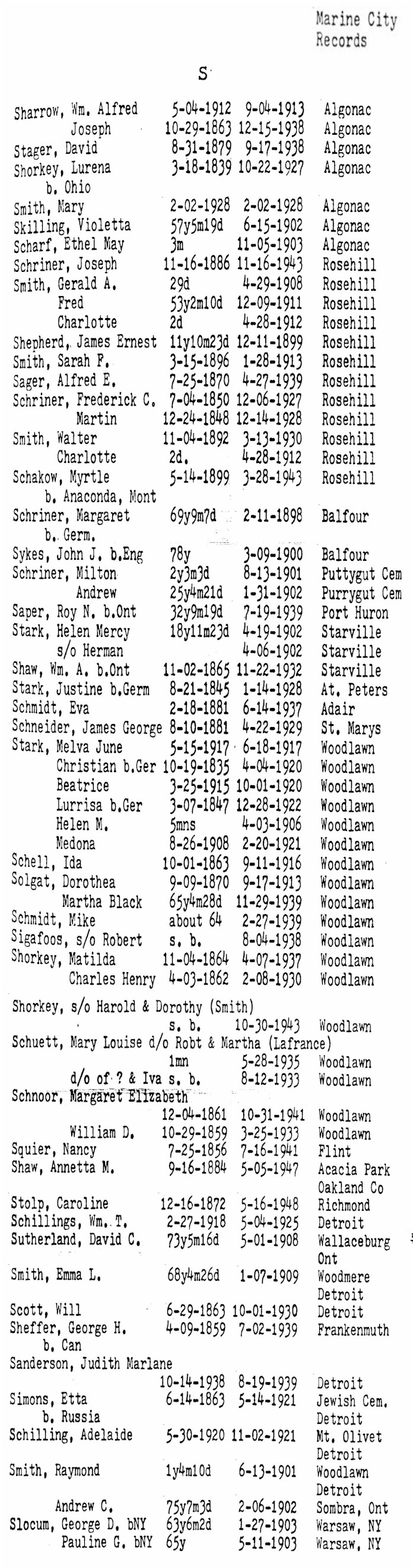
Marine
City:
Marine City residents' burials
not necessarily in St. Clair County or even Michigan.
A |
B |
C |
D |
EFG |
H |
IJK | L |
M
NOPQ |
R | S-1 |
S-2 |
TUV |
WXYZ
Database
|
Copyright
The cemetery images and searchable
databases may be downloaded and used freely for personal research.
Copying for commercial use is strictly prohibited.
|
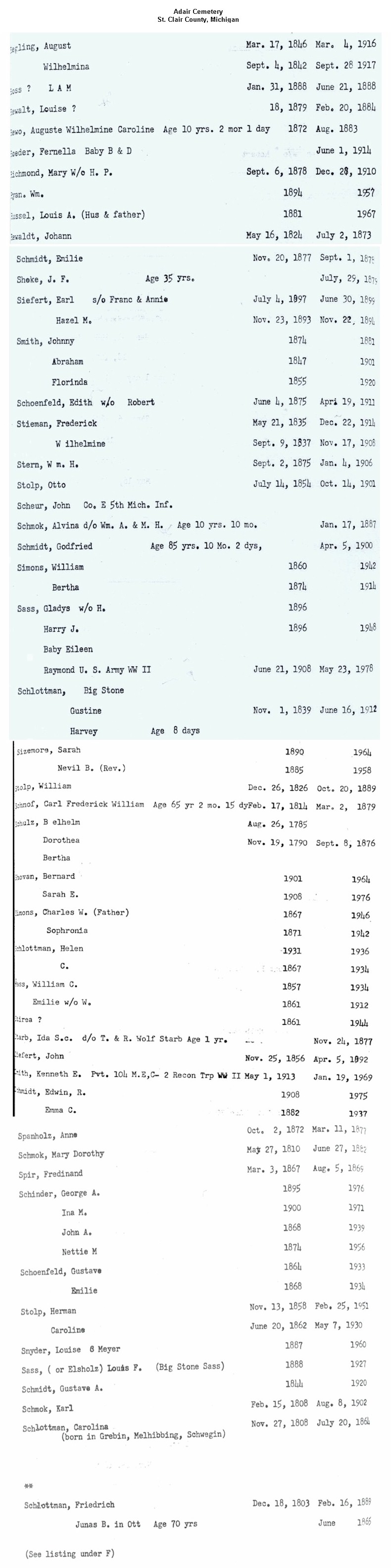
Adair Cemetery
(aka Casco
Cemetery):
Cemetery is mowed and moderately kept.
This cemetery is active.
Visited September 1999.
The oldest marker Debbie Russell saw was 1851 for Mary BORDEN, age 16y 3m.
SW 1/4, Sec. 1, Casco Twp., east side of Palms Rd., just north of St. Clair Hwy, on top of a hill.
jpg images: A-C | E-J | L-Q | R-S | T-Z |
Find-A-Grave
Allied Veterans
Cemetery
Located on Gratiot Avenue, just north of Lakeside Cemetery
Find-A-Grave
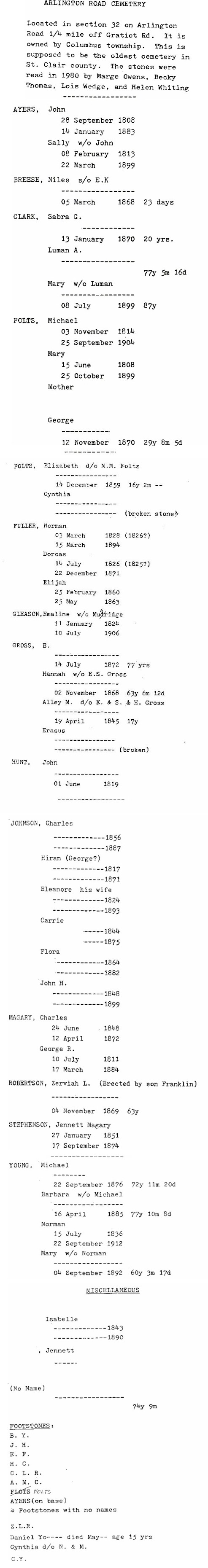
Arlington Cemetery (See
Columbus Township Burying Ground)
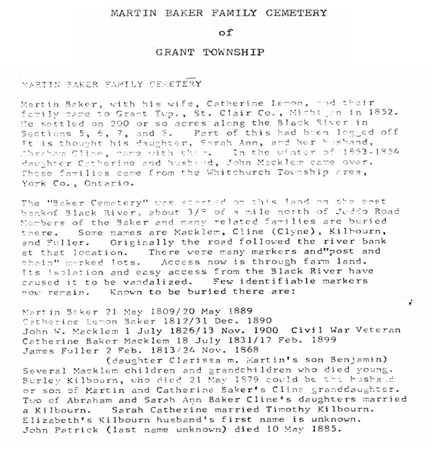
Baker Cemetery
(aka Willey
Cemetery):
No sign.
Not active. Visited in September 1999. According to our intrepid researcher Debbie
Russell:
"On the north side of Jeddo Rd. a large steel gate blocks the entrance to a private road owned by Mid Michigan Materials (a gravel and stone hauling company). This property was previously the Willey family homestead. Debbie spoke with Bill Wilson, the owner of Mid Michigan Materials, and he was extremely helpful in showing her where the cemetery was. He also told her that at a later date he will be constructing a road to go up to the cemetery. He then led Debbie to a steep trail which led to the cemetery. This cemetery is extremely overgrown and in disrepair. There are many bases that no longer have stones in them. Many markers that are there are illegible. One stone at the beginning of the path through the cemetery reads: Jonathan W. MACKLEM b. Jul 1, 1826 d. Nov 13, 1900; same marker Catherine b. Jul 18, 1831 d. Feb 21, 1899. Leaning against this stone is Jonathan's Civil War marker listing him in Co. H, 4th Michigan Infantry."
S 1/2, Sec. 6, Grant Twp. 2 miles west of Jeddo on Jeddo Rd., between Gibbons and Cribbins
Rds., on the north side of the road.
Find-A-Grave
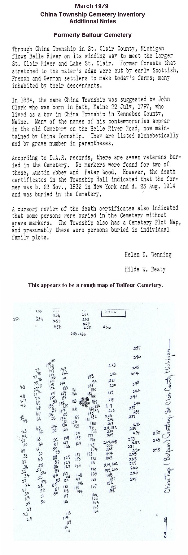
Balfour
Cemetery:
Land was donated by the Balfour family in 1865.
Well-maintained and in current use. Visited in July 1999.
Township of China, 4560 Indian Trail, China, MI 48054,
(810) 765-1145
SE 1/4, Sec. 17, China Twp. Just west of McKinley Rd. on Belle River Rd.
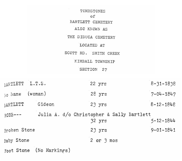
Bartlett Cemetery (aka
Diduca
Cemetery):
Listed on the map printed in the Times Herald, 20 Aug 1995, from information provided by the St. Clair County Family History Group.
Kimball Twp., Scott Rd. east of the Pine River
Bethel Cemetery
(aka Evangelical Cemetery):
Listed on the map printed in the Times Herald, 20 Aug 1995, from information provided by the St. Clair County Family History Group.
Mussey Twp., on Imlay City Rd. near Capac
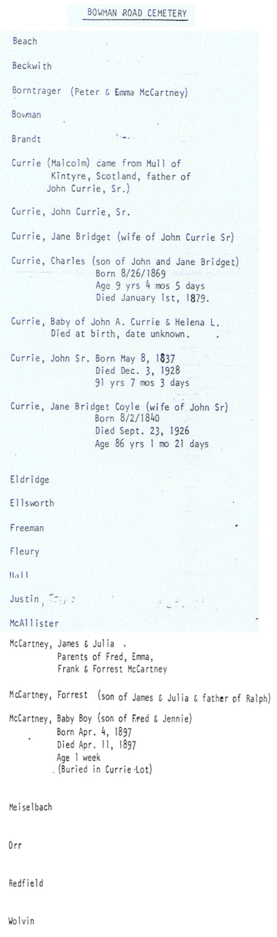
A small, "pleasantly wooded, old-fashioned" country cemetery, according to Suzanne Frantz.
There are a few Civil War veterans buried here; someone puts little U.S. flags on the graves.
It's well maintained but not currently used. Visited in June 1999.
SW 1/4, Sec. 24, St. Clair Twp. In the triangle formed by the intersections of Bowman, Allen and Yankee
Rds.
Database
(partial) |
Find-A-Grave
Update
February 2006 - thanks to site visitor Don Justin, CWO USN (Ret.) [drj1229@yahoo.com]
Brockway
Cemetery
(See Moore Cemetery)
Burtchville Township
Cemetery (See
Lakeport
Cemetery)
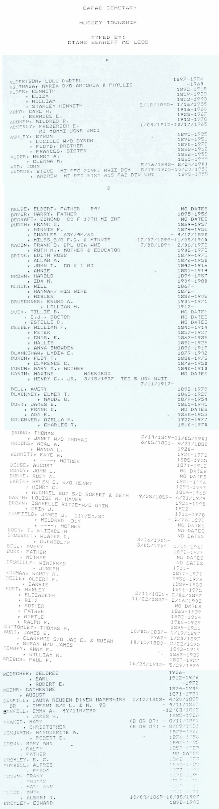
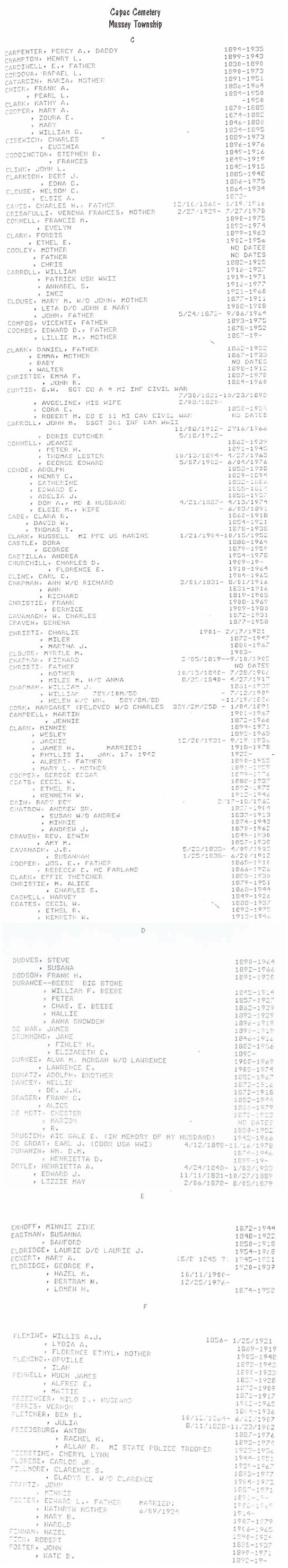
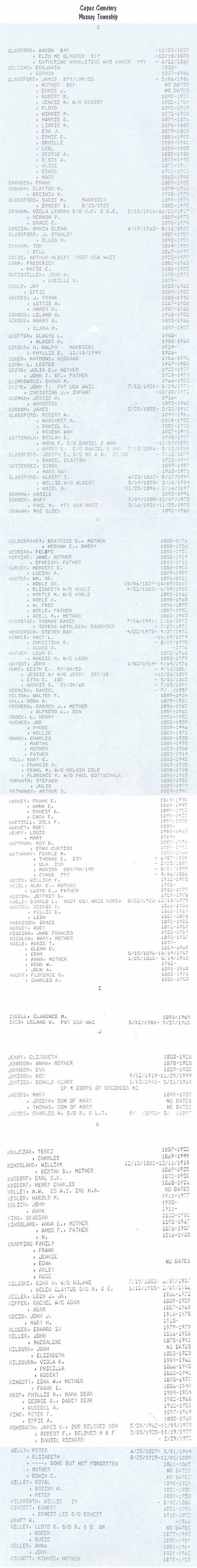
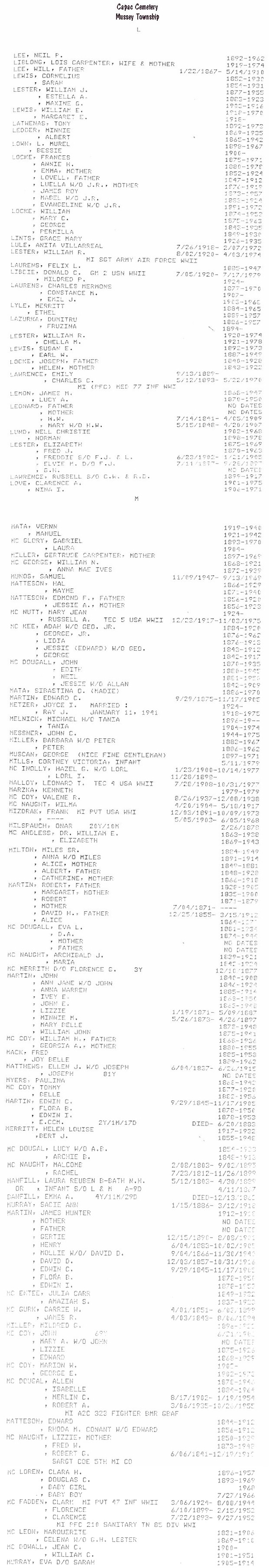
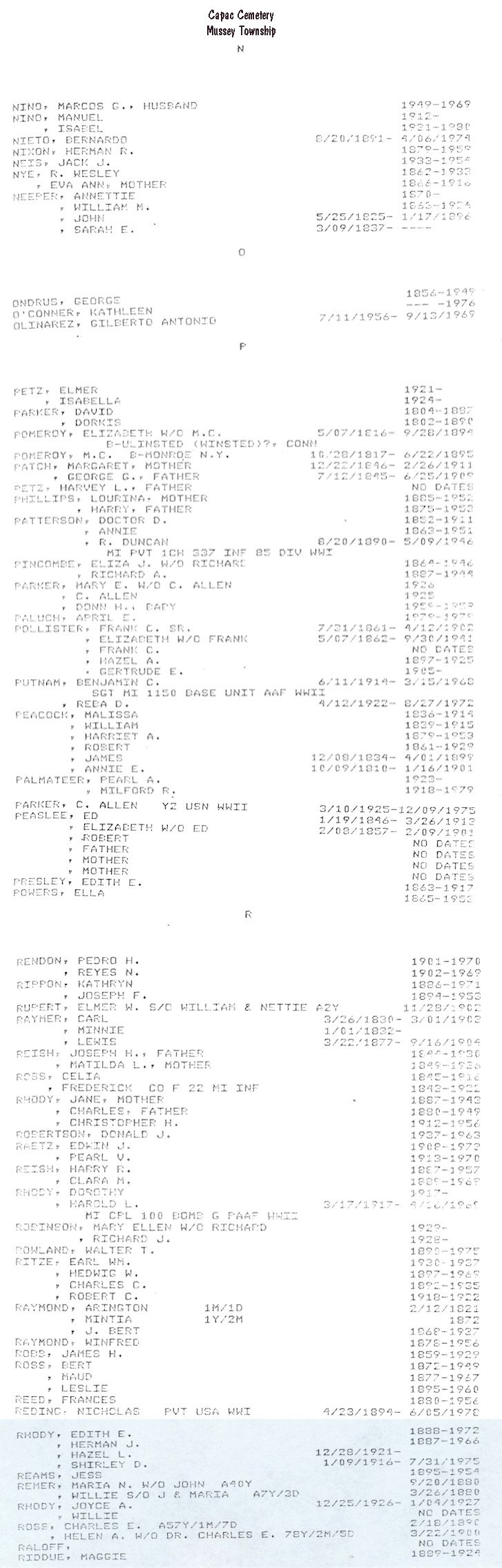
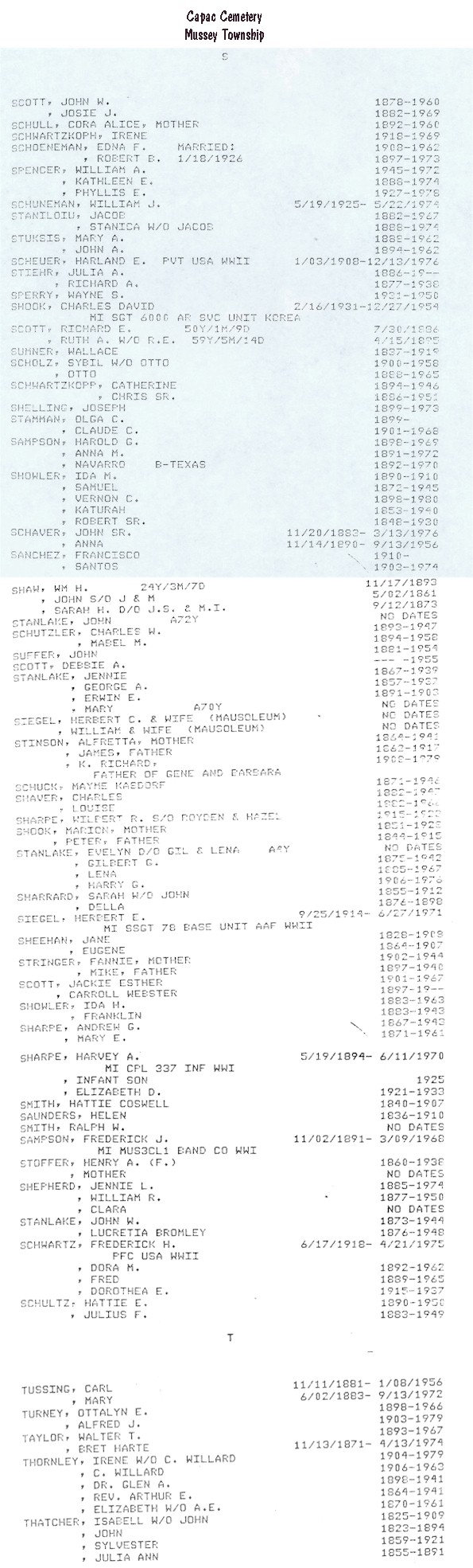
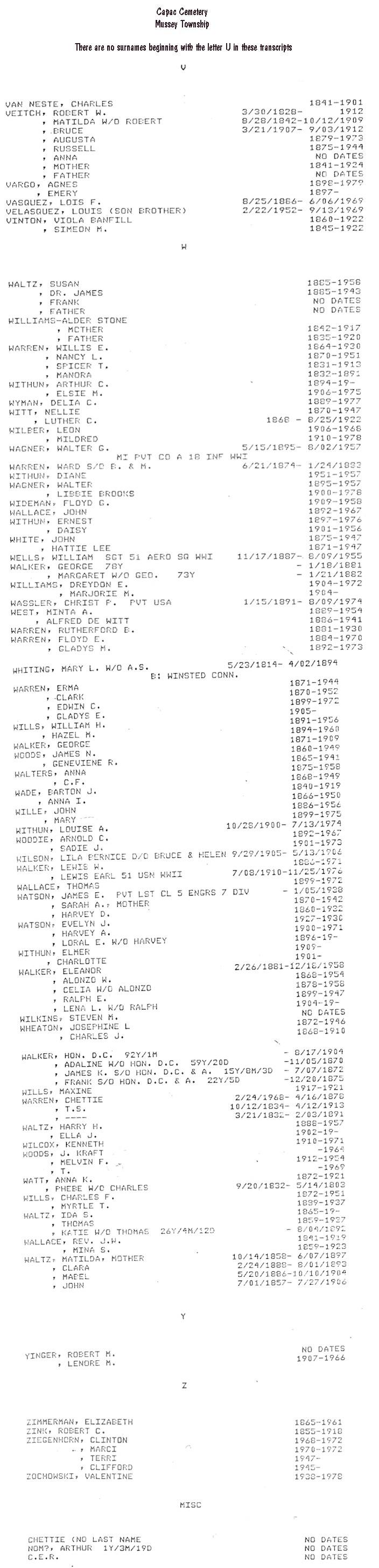
Capac Cemetery:
Suzanne Frantz and her husband visited this cemetery in November of 1999.
She reports that the cemetery has a Civil War memorial, a statue of a Union soldier.
Well-maintained by the village or Capac, Mussey Twp, or both, and in current use.
Visited in July 1999.
NW 1/4, Sec. 34, Mussey Twp. 1 mile south of Capac on the east side of Capac Rd., between Donald and Koehn
Rds.
A-B
| C-F |
G-K |
L-M
| N-R |
S-T |
U-Z |
Find-A-Grave
Casco Cemetery
(See St. James and
Adair Cemeteries)
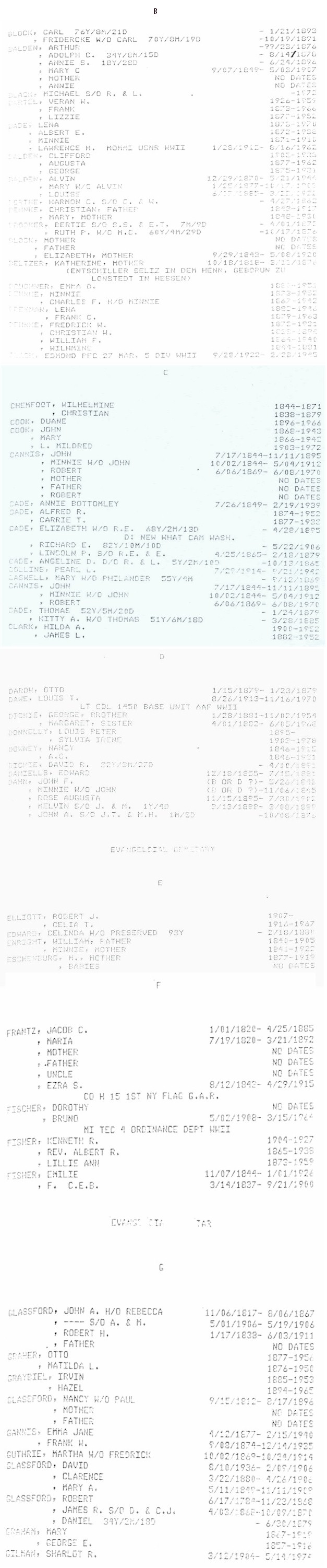
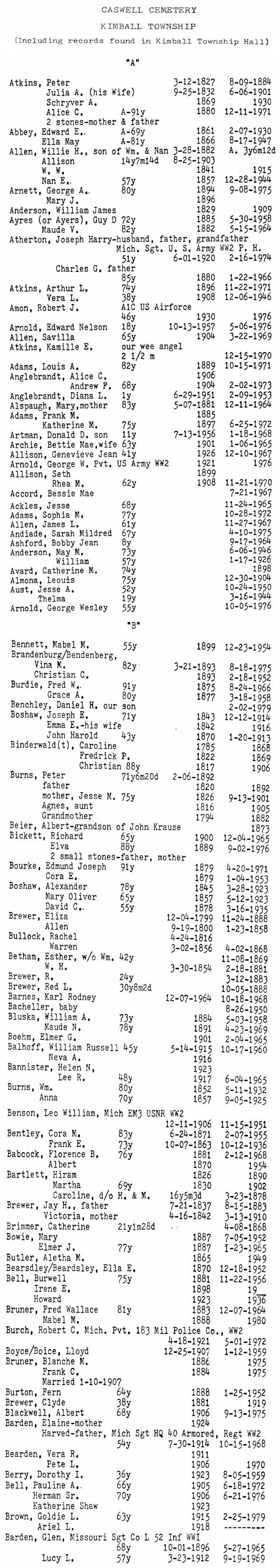
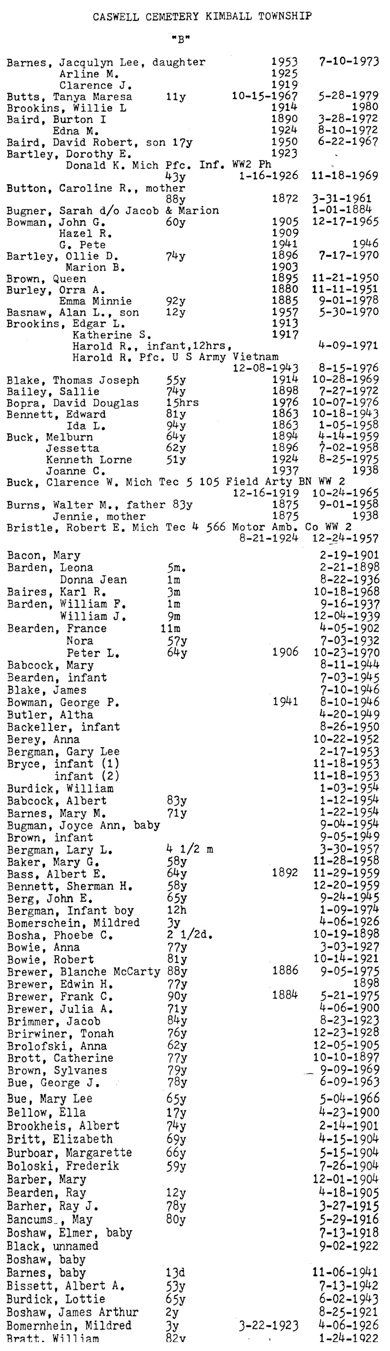
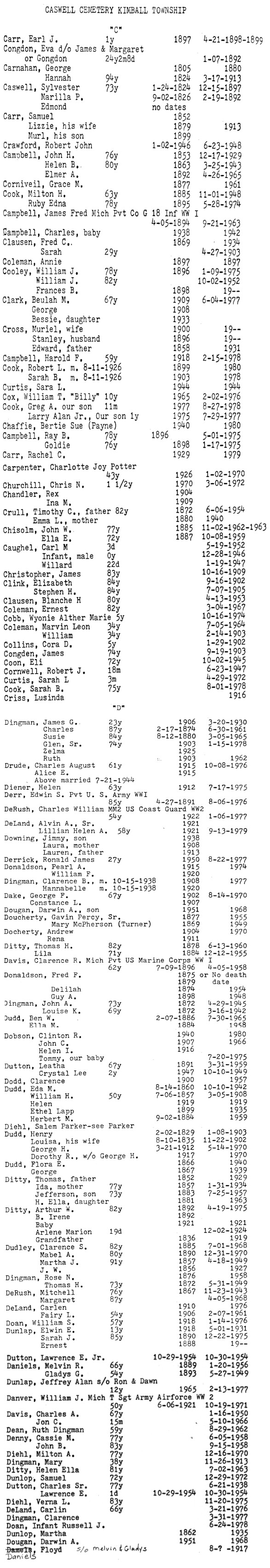
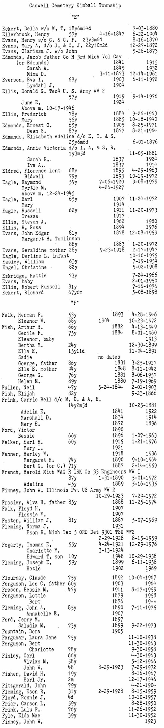
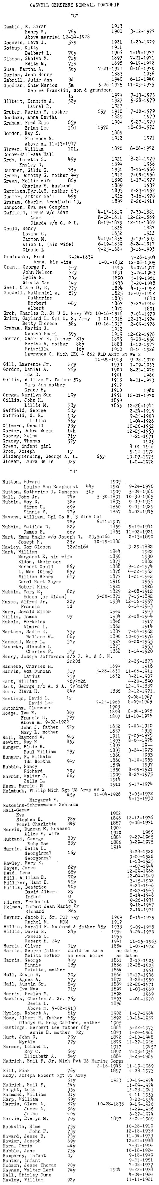
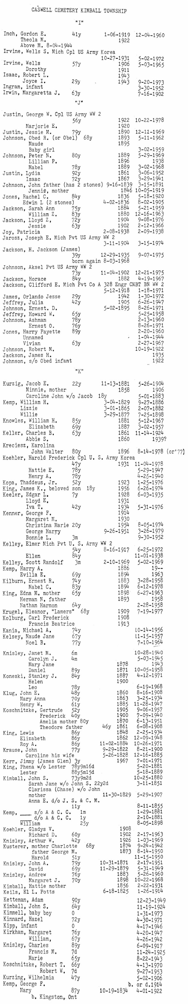
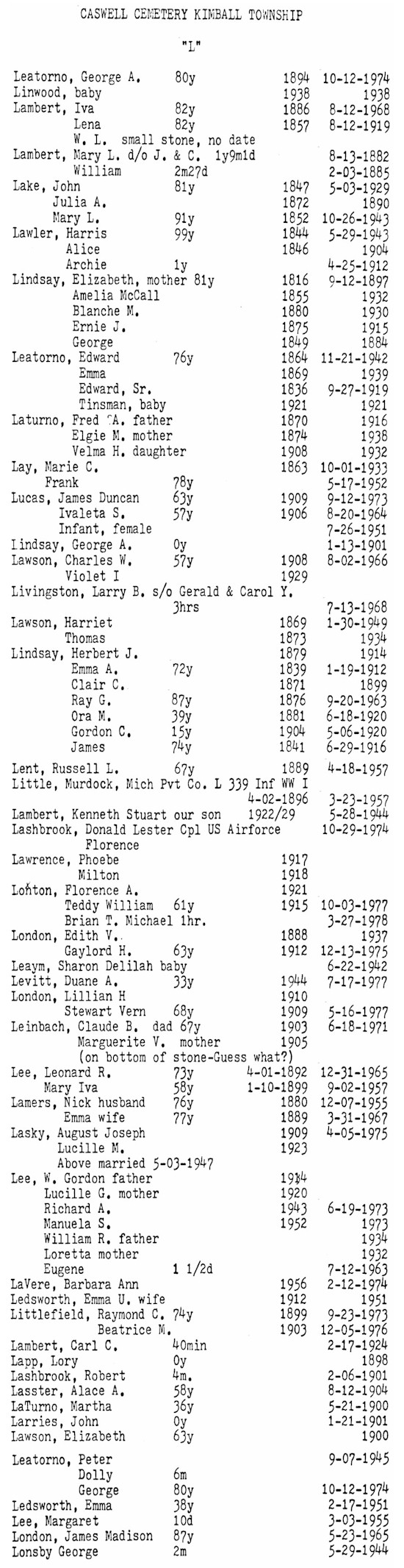
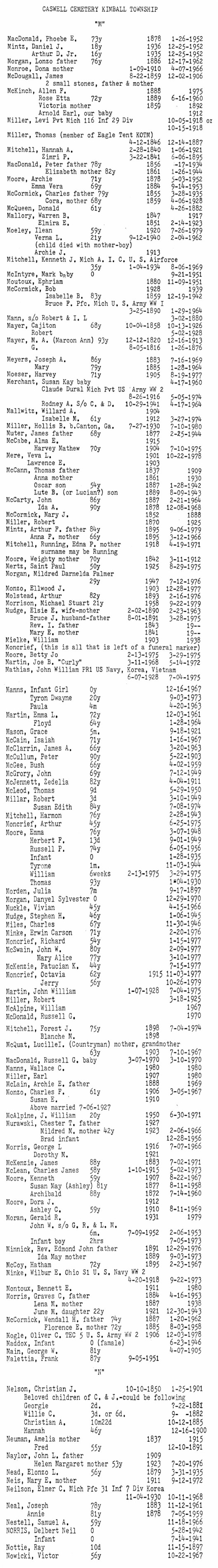
Caswell
Cemetery:
The older graves, dating from the 1860s and 1870s, are on the north side of the road. Large maple trees engulf this cemetery.
Well-kept and still active, says Debbie Smith Russell. Visited in July 1999.
NE 1/4, Sec. 18, Kimball Twp. Just west of Richman Rd. on both sides of Burns Rd.
A-B |
B |
C-D |
E-F |
G-H |
I-K |
L |
M-N |
O-P |
R |
S
| T-V |
W-Z & Odd
|
Find-A-Grave
Clarke (Clark) Cemetery:
This cemetery is mowed but not very well-kept, according to Debbie Smith Russell. It appears to back up to the Belle River on the north side. Burials are from the 1800s; no recent burials are evident. It's on private land, marked with yellow plastic bags. Debbie says there's no sign, but a map in the Times Herald from 20 Aug 1995 shows "Clarke Cemetery" in this location. Visited in July 1999.
SE 1/4, Sec. 17, China Twp. About 500 feet west of Indian Trail on Lindsey Rd., on the north side of the road.
Find-A-Grave
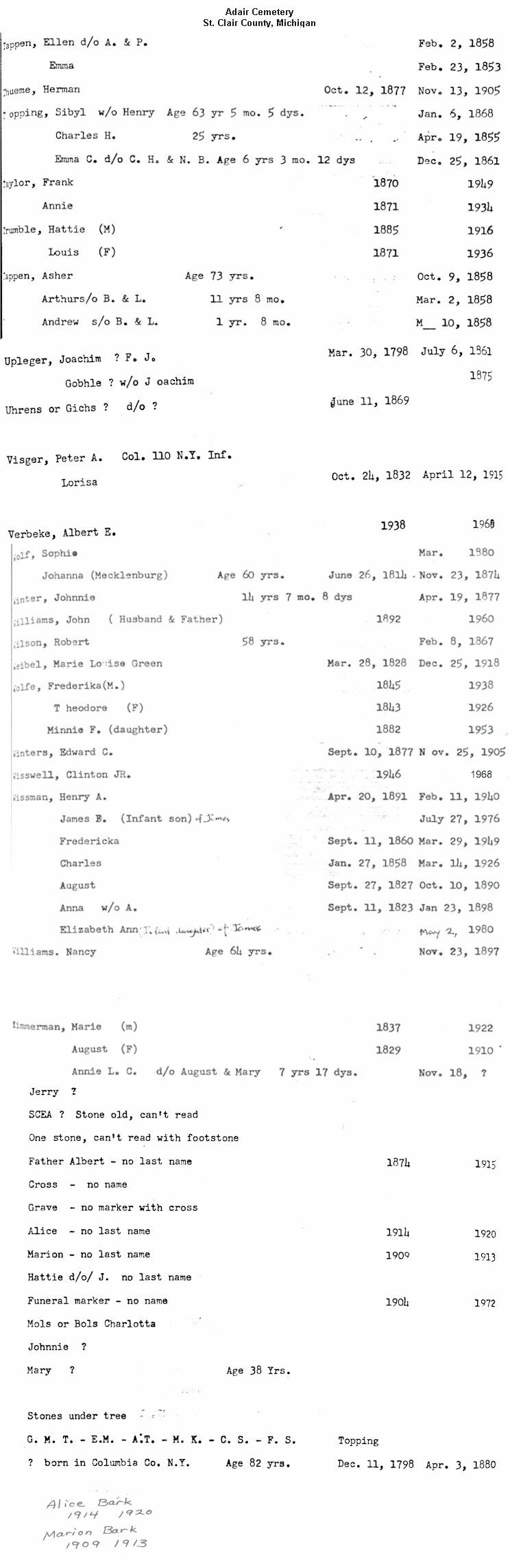
Columbus Township Burying Ground (aka
Arlington
Cemetery):
Suzanne Frantz visited this one in August 1998. At that time, she says it was "a most eerie place, old stones falling over and all overgrown with day lilies and vines, set among a grove of some of the biggest trees I've seen in Michigan. Although someone had re-dedicated (it) in the 70's with a wooden marker, it appears no one has maintained it." Sue notes that the area around Arlington and Gratiot
Rds. was a bustling town known as Columbus (not the same as the small town on Rattle Run Rd. today). Revisited by Tom Kephart in July 1999.
Revisited by Kathleen Rodegeb in June 2007. It's much the same as Suzanne
reported back in 1998, except that someone has placed "wooden"
tulips on many of the graves (very sweet). In spite of being eerie, it's a
lovely place. Some tombstone photos have been placed on the tombstones
page.
SE 1/4, Sec. 29, Columbus Twp. On the east side of Arlington Rd. just north of Gratiot Rd.
jpg images of grave
transcriptions |
Find-A-Grave
Conlon
(Collins) Cemetery
(See Harmony Cemetery)
Diduca
Cemetery
(See Bartlett Cemetery)
East
Berlin Cemetery
(aka
Hoover Cemetery):
A large, well-maintained cemetery in current use. Graves date to the 1850s. Maintained by Berlin
Township (see also West Berlin Cemetery).
Suzanne Frantz and her husband visited this cemetery in November of 1999. Suzanne reports that it is one of the loveliest settings she's seen, set among the towering pine trees. Someone has lovingly patched up some of the tumbled stones.
Township of Berlin,
13892 Hough Road Allenton, MI 48002, (810) 784-9969
S 1/2, Sec. 14, Berlin Twp. 2.5 miles west of Riley Center on Masters Rd., between Sperry and Berville
Rds.
A-B |
C-E |
F-G |
H-J |
K-L |
M-O |
P-R |
S |
T-V |
W-Z |
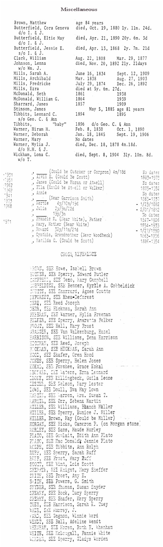
Miscellaneous
| Cross-reference to database
|
Find-A-Grave
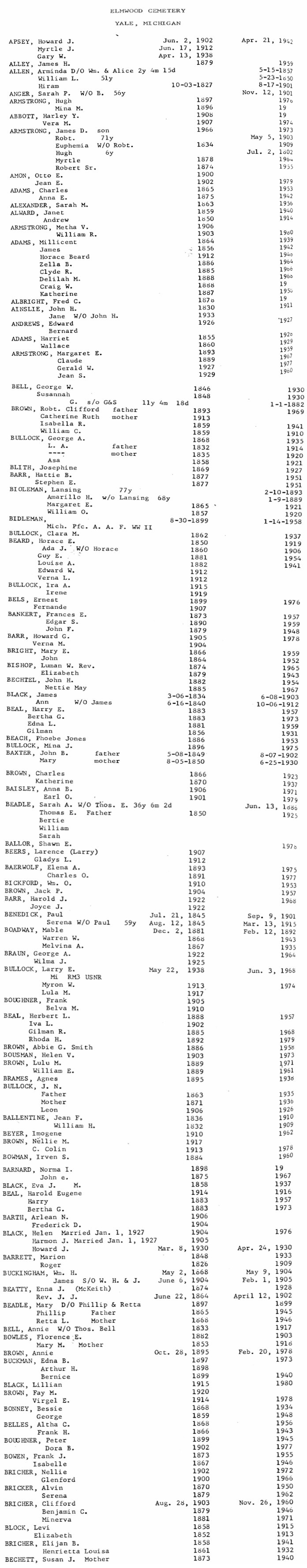
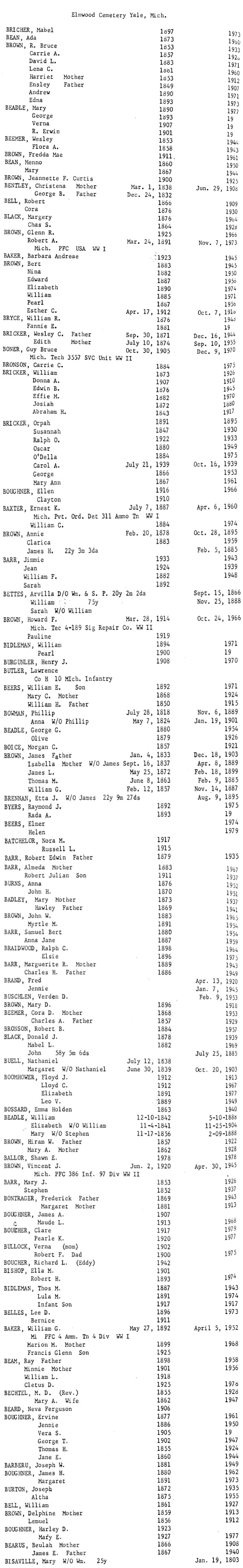
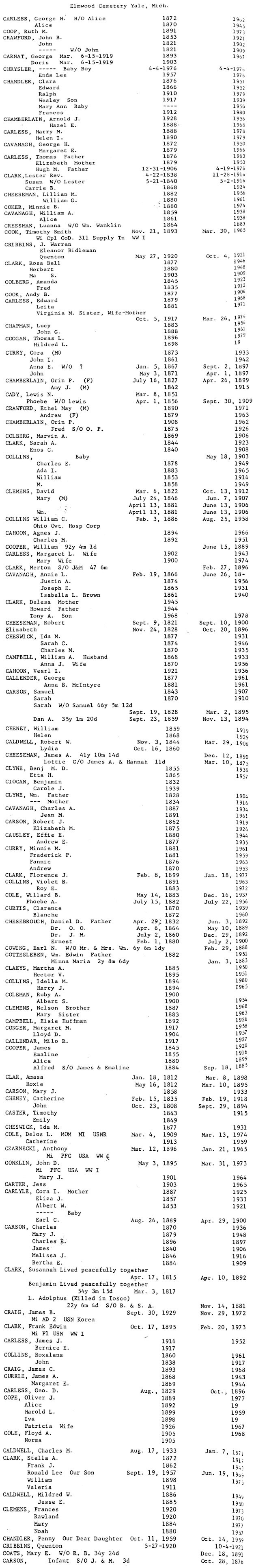
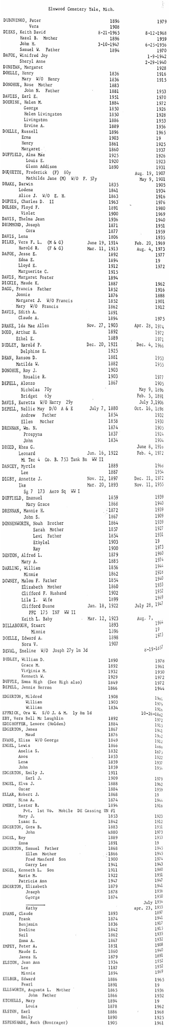
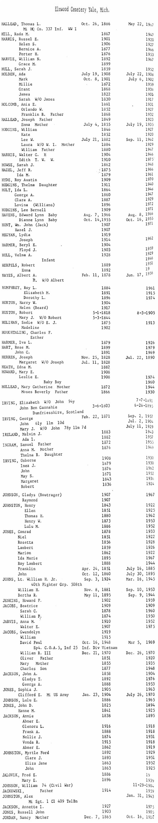
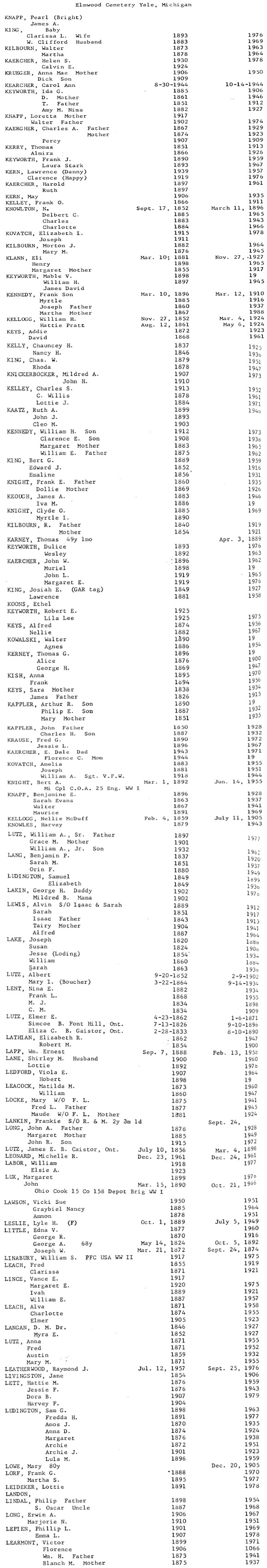
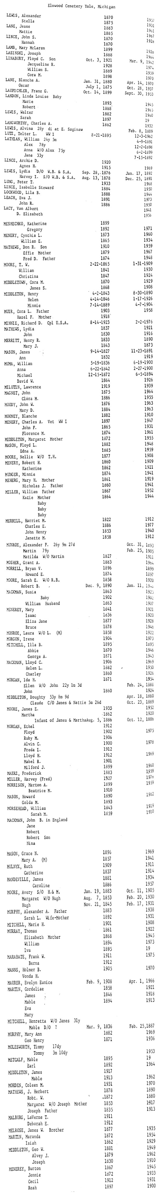
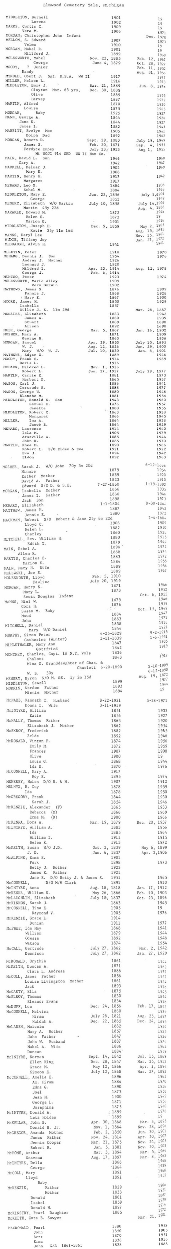
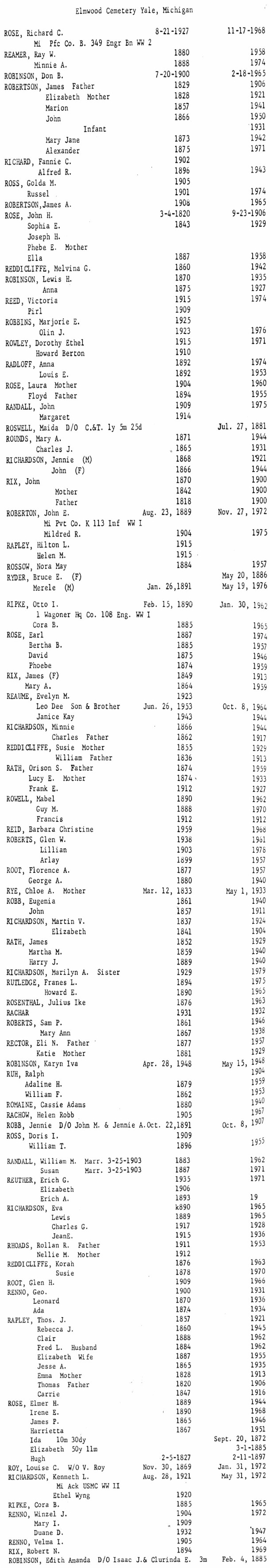
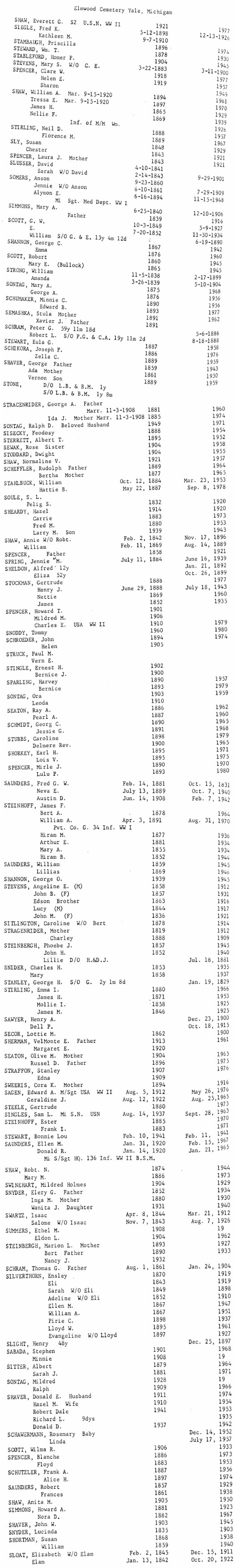
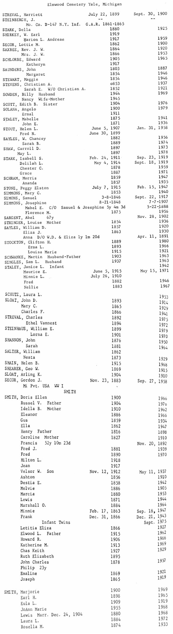
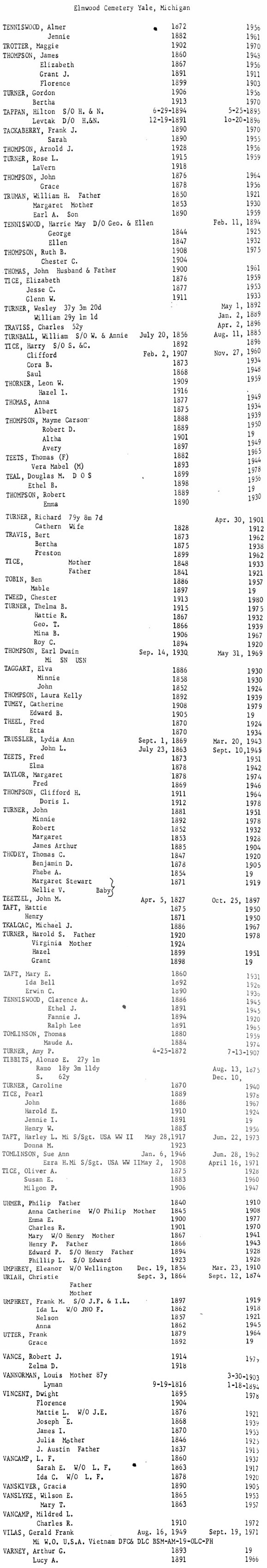
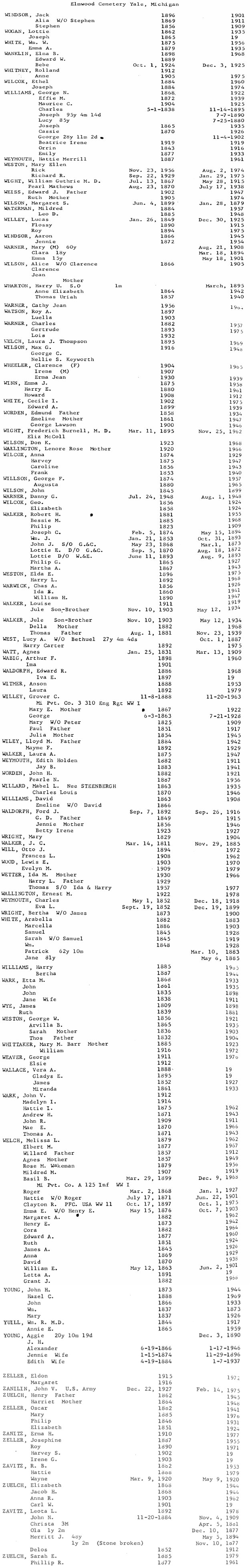
Elmwood
Cemetery:
Very large, well-maintained public cemetery, with many recent burials.
Private
Sacred Heart Cemetery is adjacent, just to the
east. Visited in July 1999.
City of Yale,
111 West Mechanic St.,
Yale, MI 48097, (810) 387-3311
SW 1/4, Sec. 10, Brockway Twp. Just west of Yale on Yale Rd.
A-B |
B |
C |
D-E | F-G |
H-J |
K-L |
L-M |
M |
N-P | Q |
R |
S-1 |
S-2 |
T-V |
W-Z
| Database
|
Find-A-Grave
Evangelical
Cemetery
(See Bethel Cemetery):
Suzanne Frantz and her husband walked this cemetery on November 20, 1999. Suzanne reports that it is a nicely-maintained, country cemetery, on the north side of the road, adjacent to a brick church. Today the church is Methodist, although the engraving over the doorway reads "Zion Kirghe du Gemeinschaft 1892." There are large markers in the cemetery, including Civil War graves with their GAR markers.
Find-A-Grave
First Congregational Church
Columbarium Find-A-Grave
Grace Episcopal Church
Columbarium
Find-A-Grave
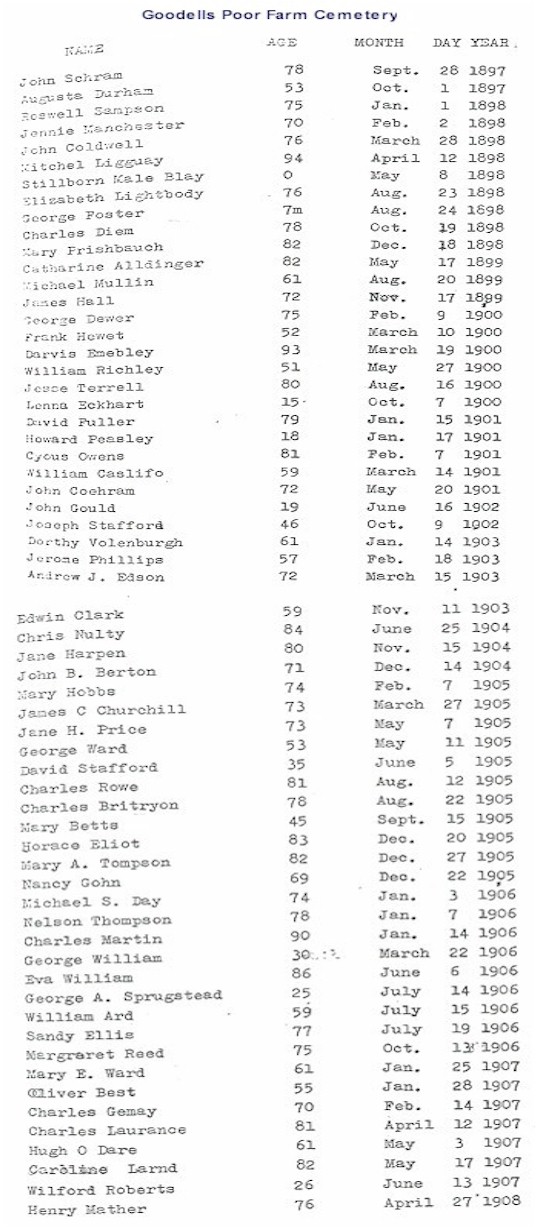
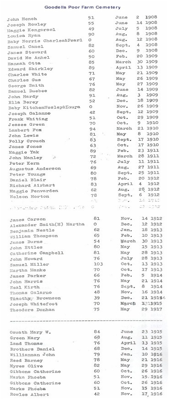
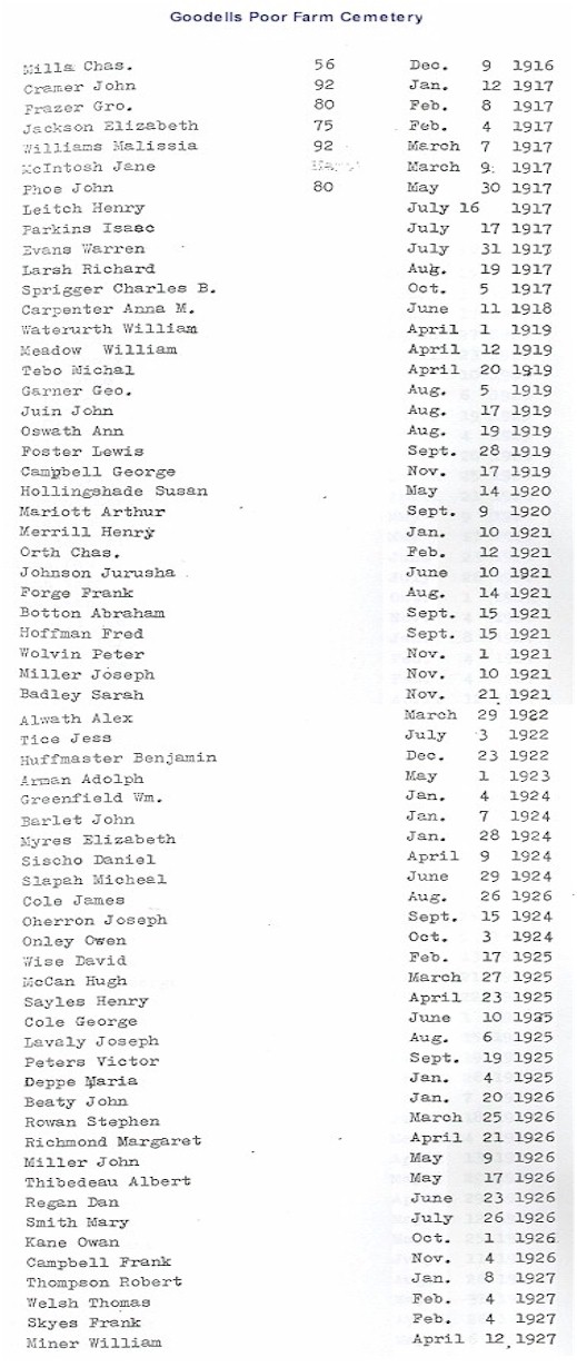
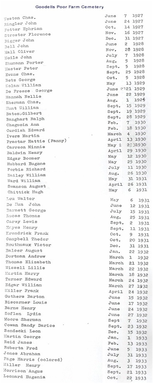
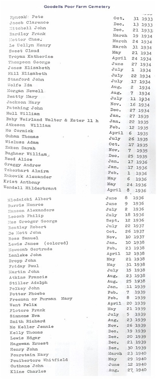
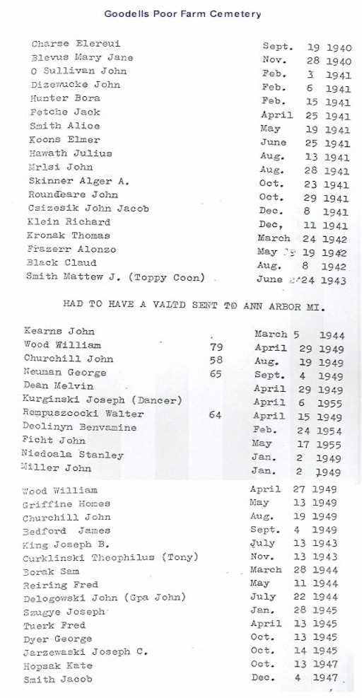
Goodells
Poor
Farm Cemetery:
Listed on the map printed in the Times Herald, 20 Aug 1995, from information provided by the St. Clair County Family History Group.
Wales Twp., on County Park Rd.
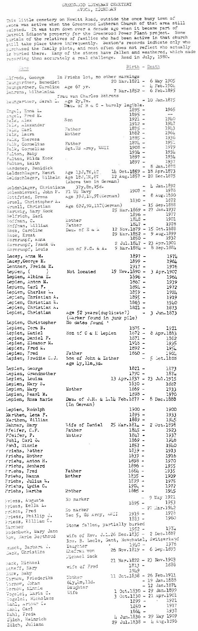
Greenwood Cemetery (may also be known as
Lutheran Cemetery):
SW 1/4, Sec. 26, Greenwood Twp. SW of Fargo on Hewitt Rd., between Fargo and Duce Rds. On Plum Creek.
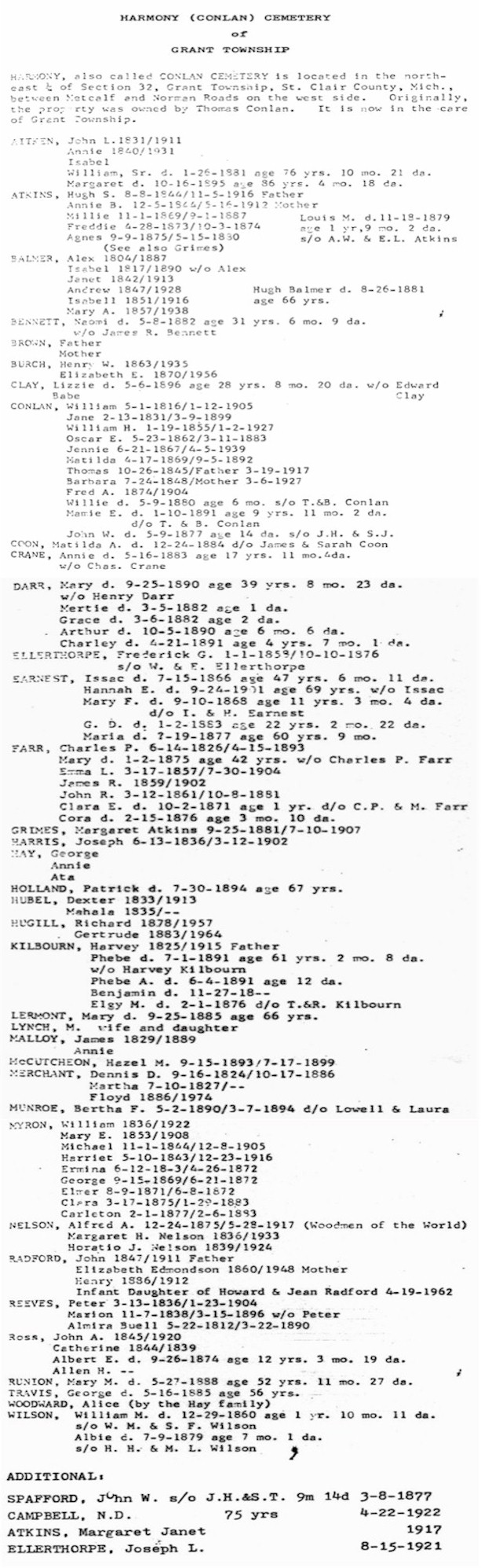
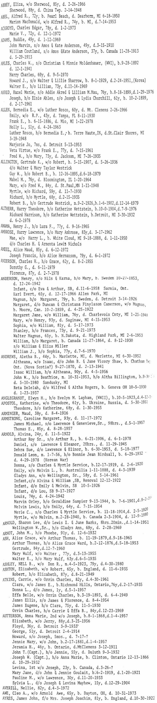
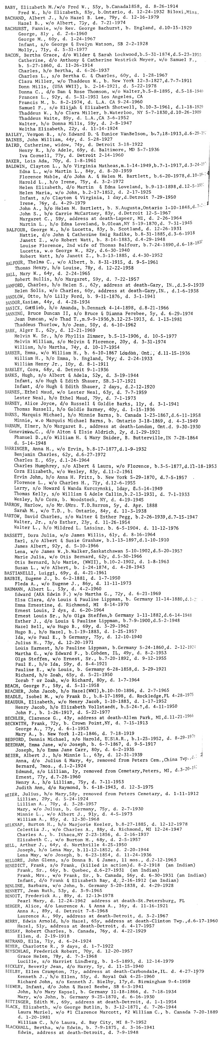
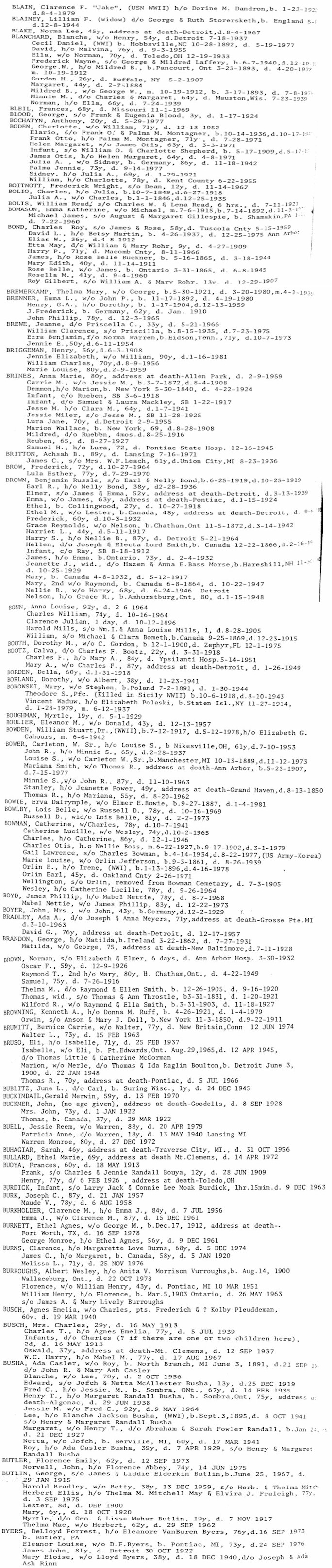
Harmony Cemetery (aka
Conlon
Cemetery):
Gloria Reeves states that this cemetery was on land owned by Thomas CONLON, and may have also been known as the Conlon Cemetery at one time. Several of her husband's ancestors were buried there. There are burials from 1861 or earlier. The grass had been recently cut when Gloria and her husband were there, but the old stones have faded to where they could hardly read them. Visited in June 1999.
NE 1/4, Sec. 32, Grant Twp. Just south of Norman Rd. on Gibbons Rd.
Database |
Find-A-Grave
Harrington Cemetery:
Listed on the map printed in the Times Herald, 20 Aug 1995, from information provided by the St. Clair County Family History Group.
Port Huron Twp., on Beach Rd. along the Black River
Henry Robinson's
Cemetery
(See Robertson's Land):
This may actually be referring to Robertson's Land. If anyone can verify this please
let me know.
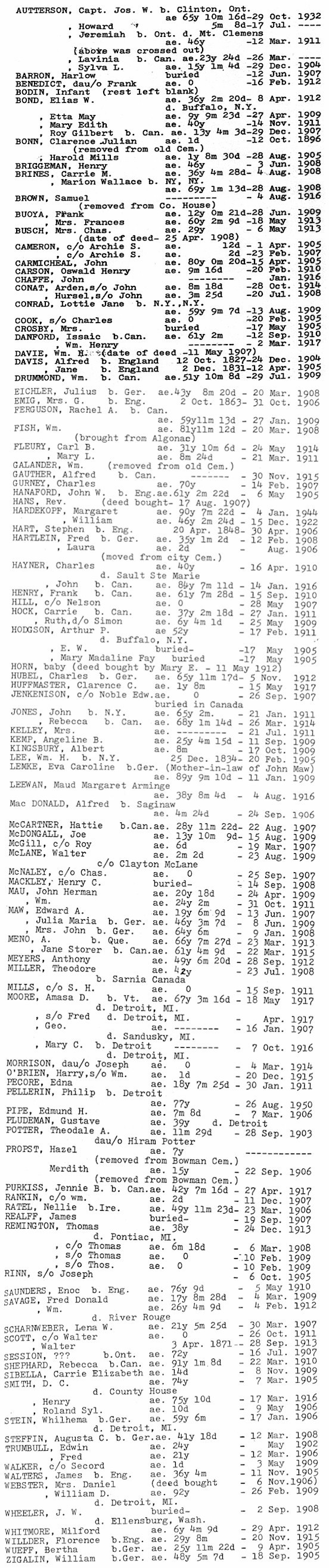
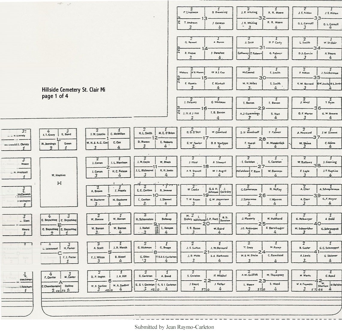
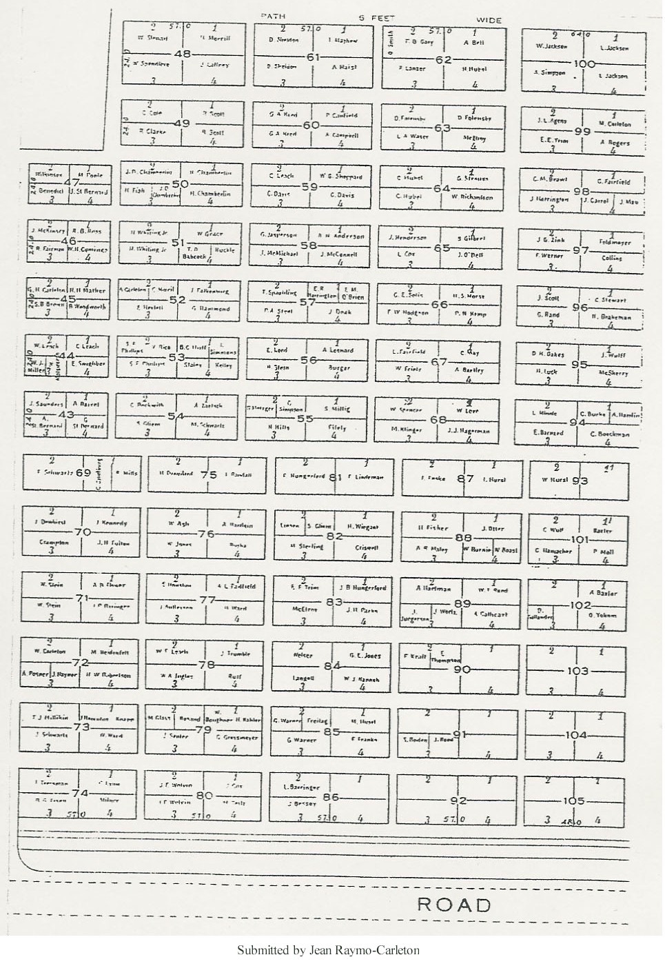
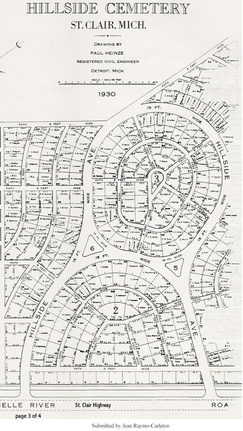
Hillside
Cemetery:
City-owned public cemetery, in current use and well-maintained.
In the city of St. Clair, on St. Clair Hwy. between Palmer and Oak Sts. near the south city limits.
City of St. Clair,
411 Trumbull St.,
St. Clair MI 48079, (810) 329-7121
1450 Goffe St.,
St. Clair, MI 48079
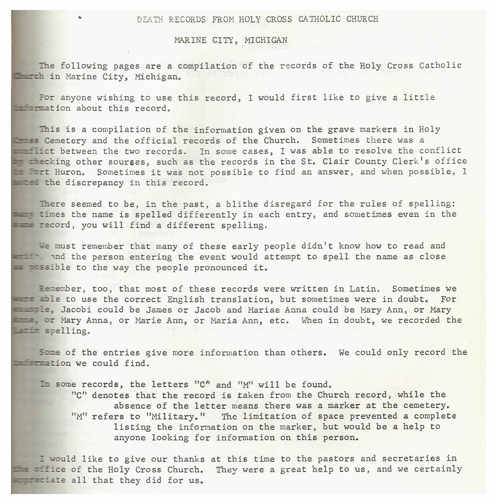
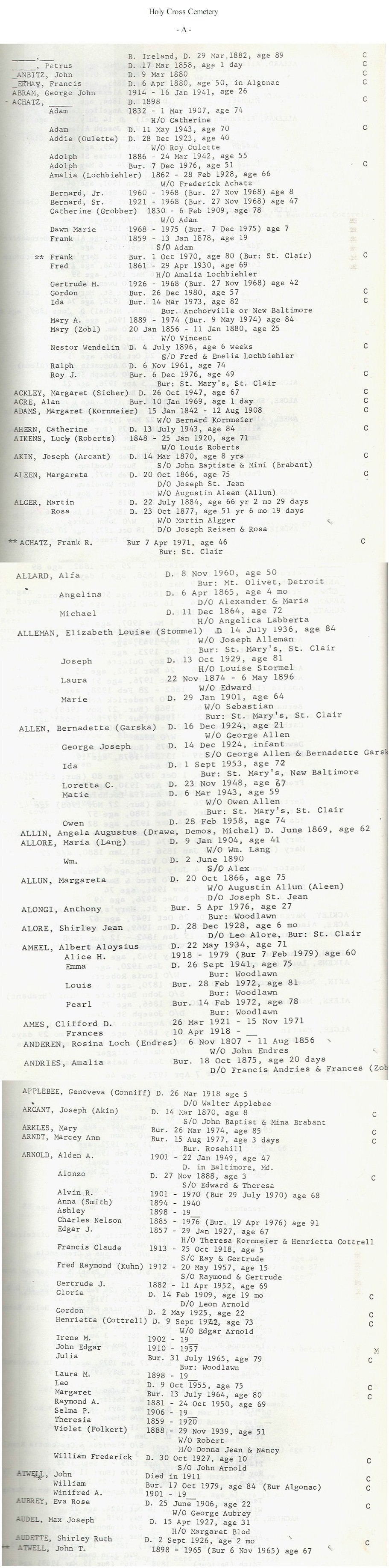
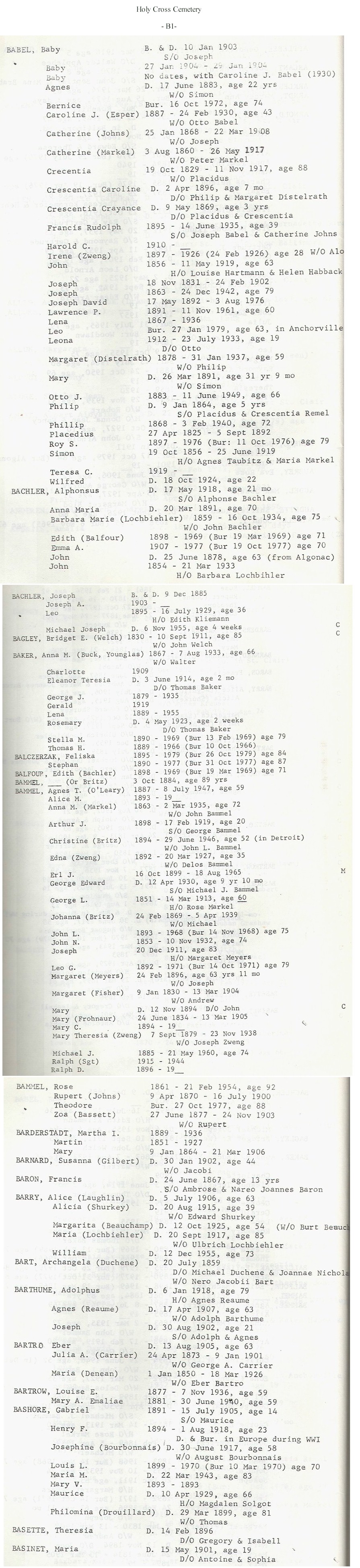
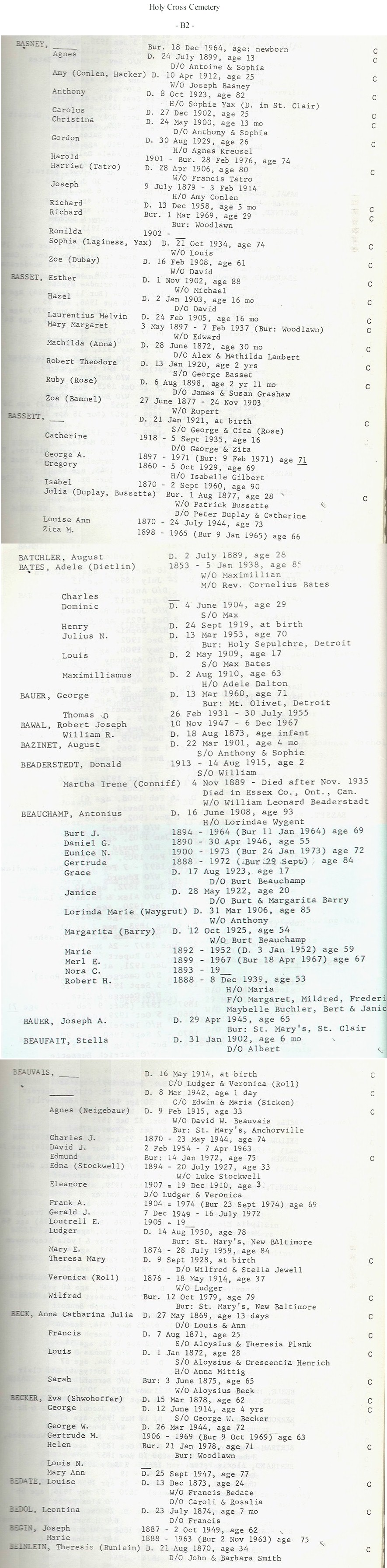
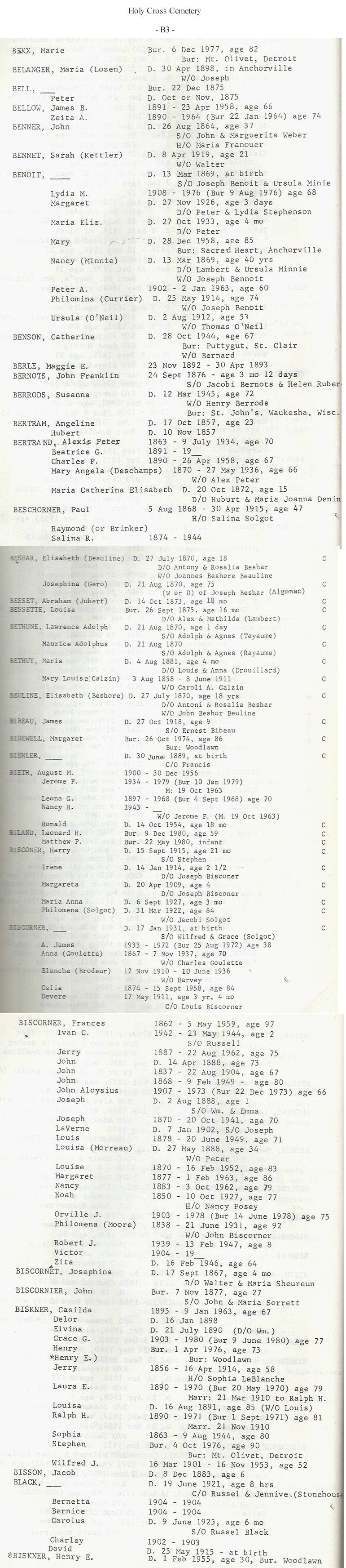
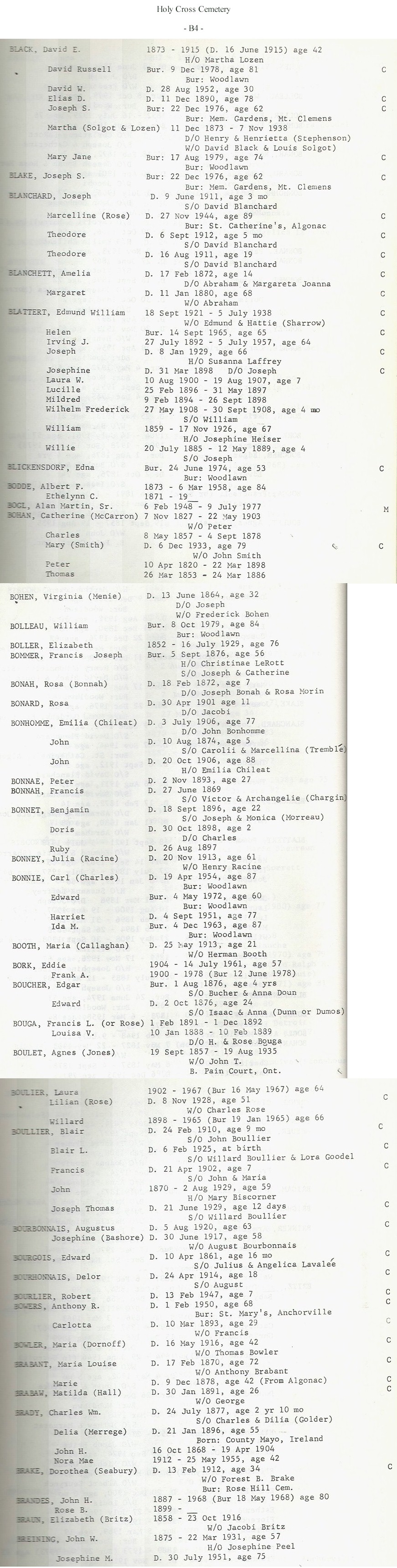
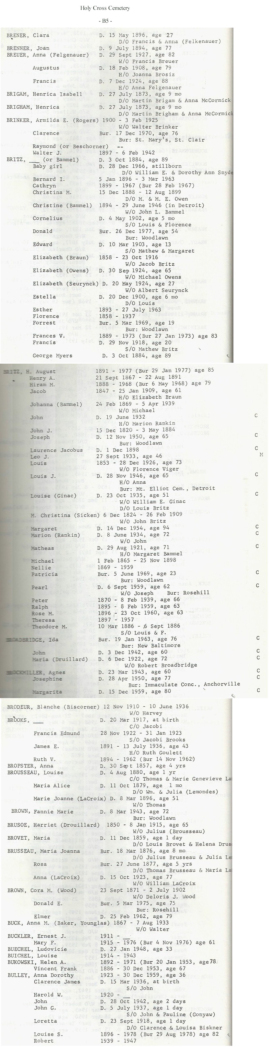
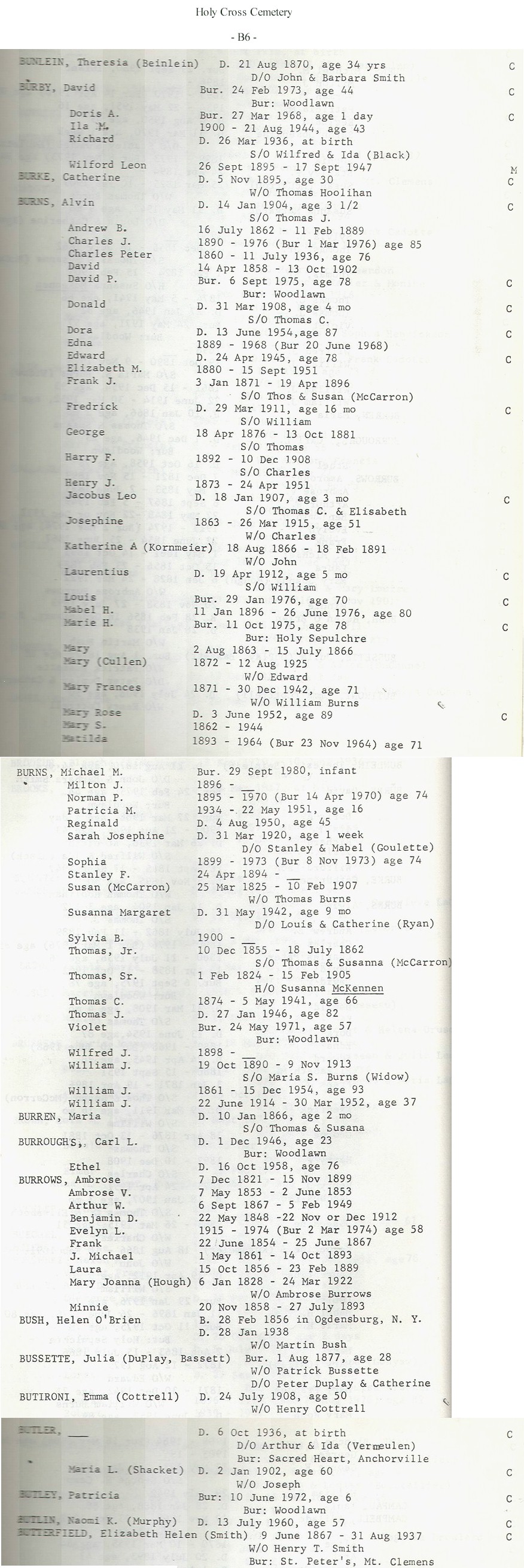
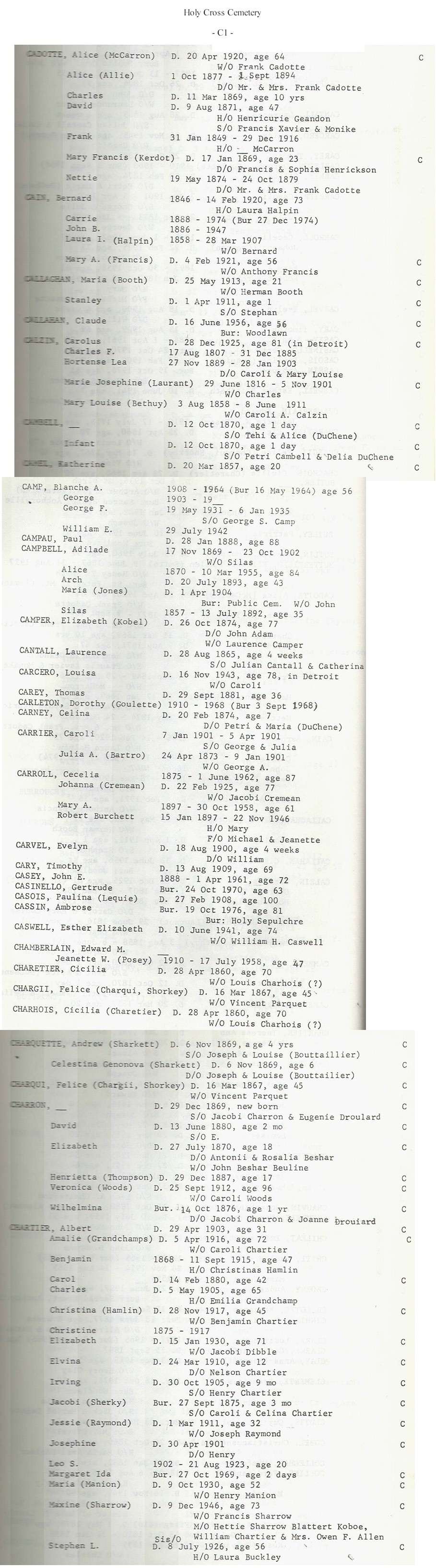
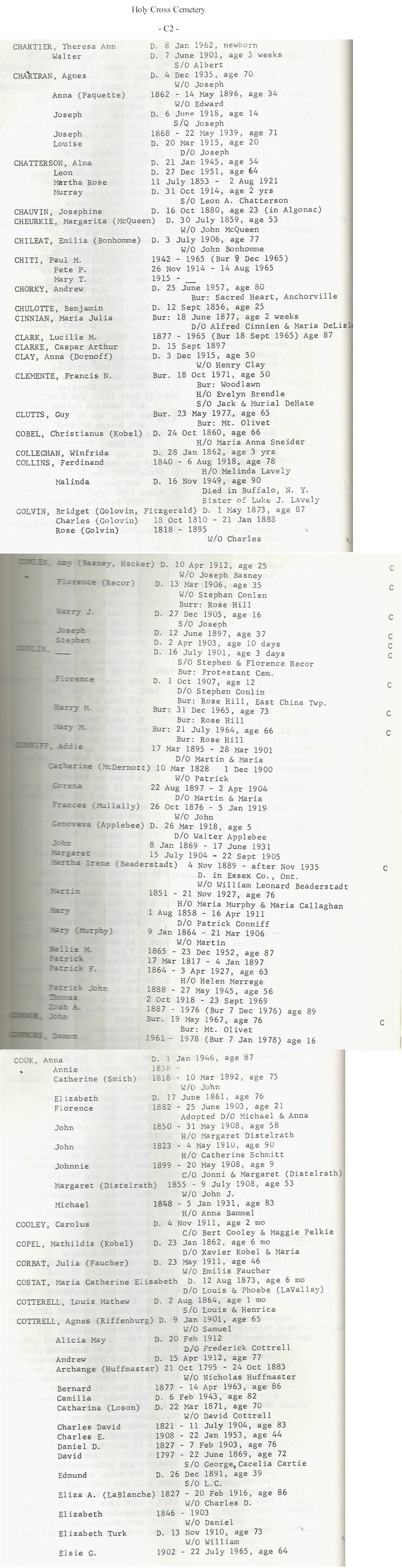
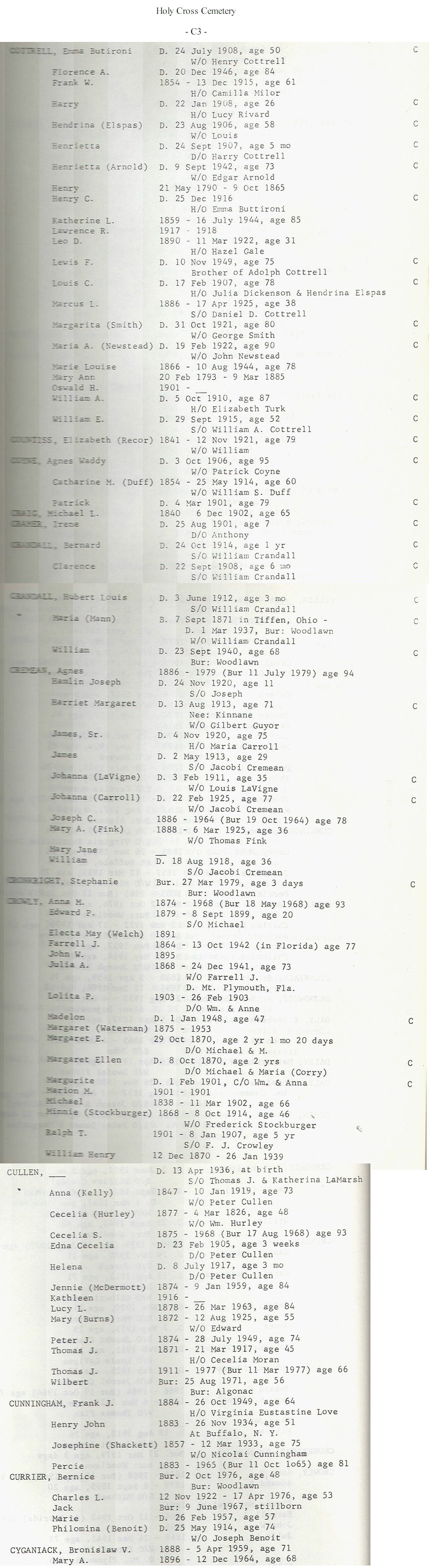
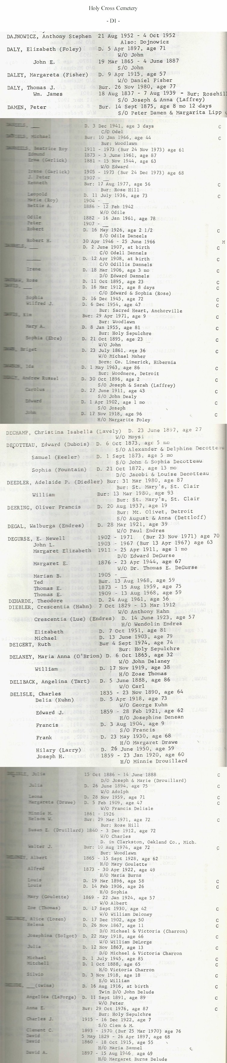
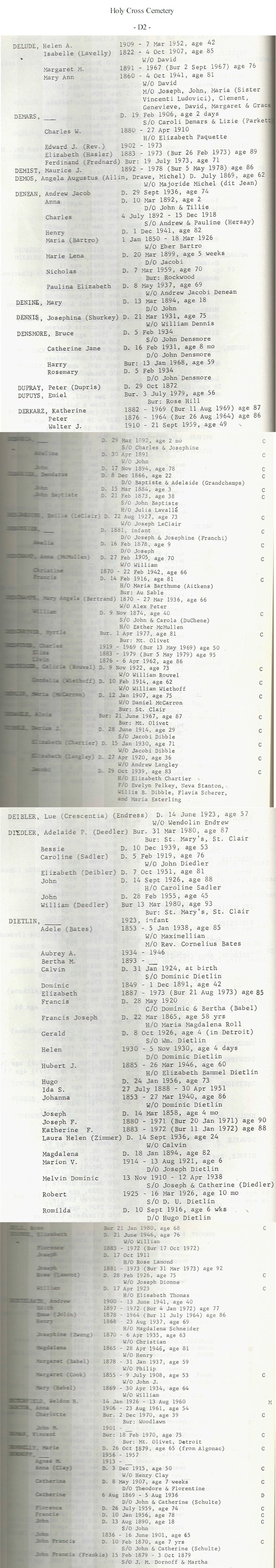
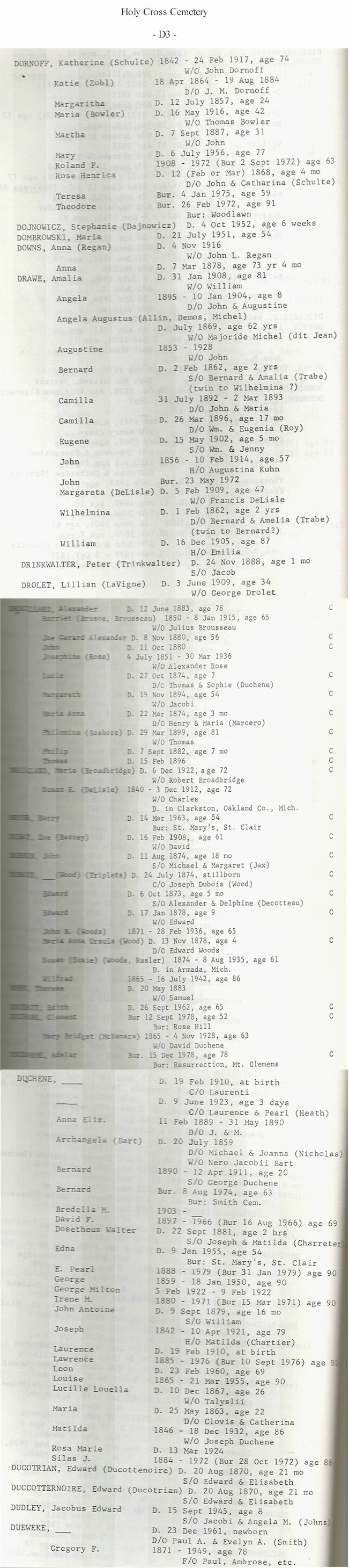
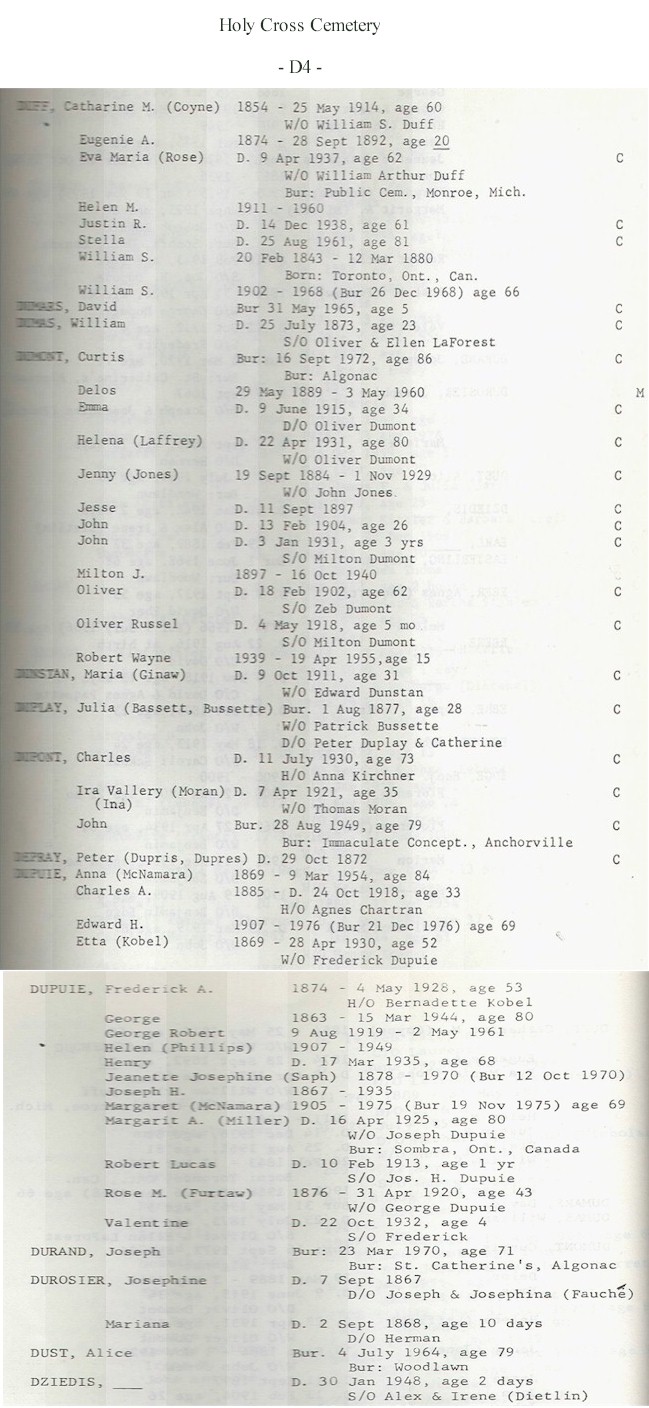
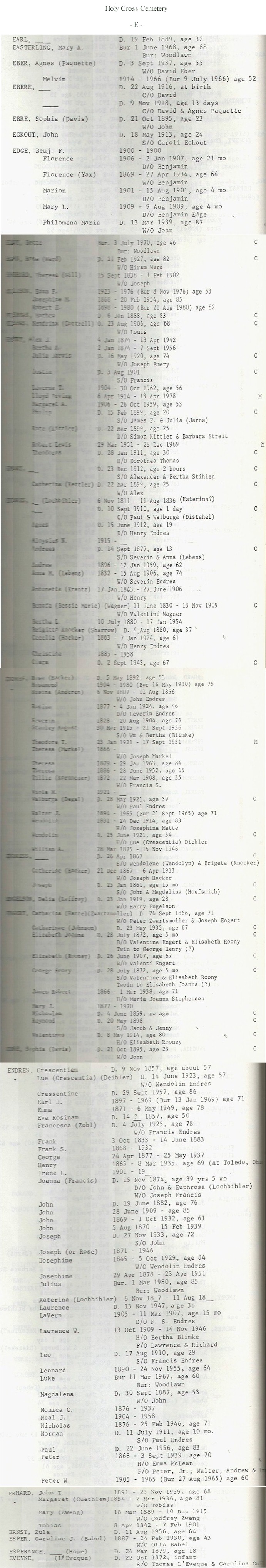
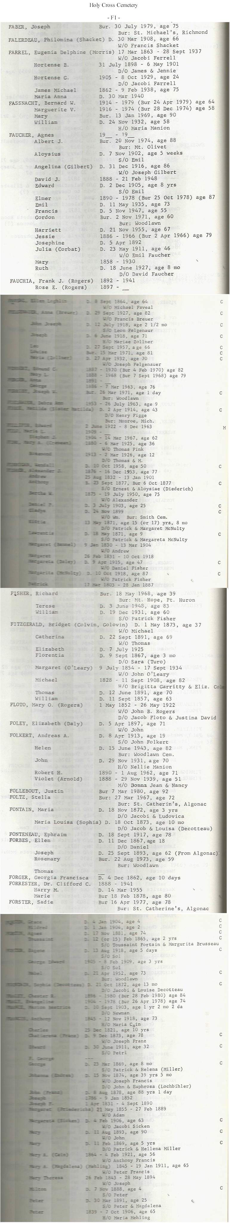
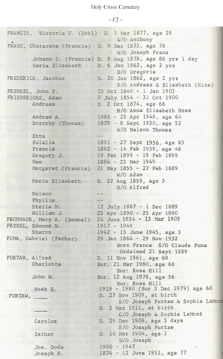
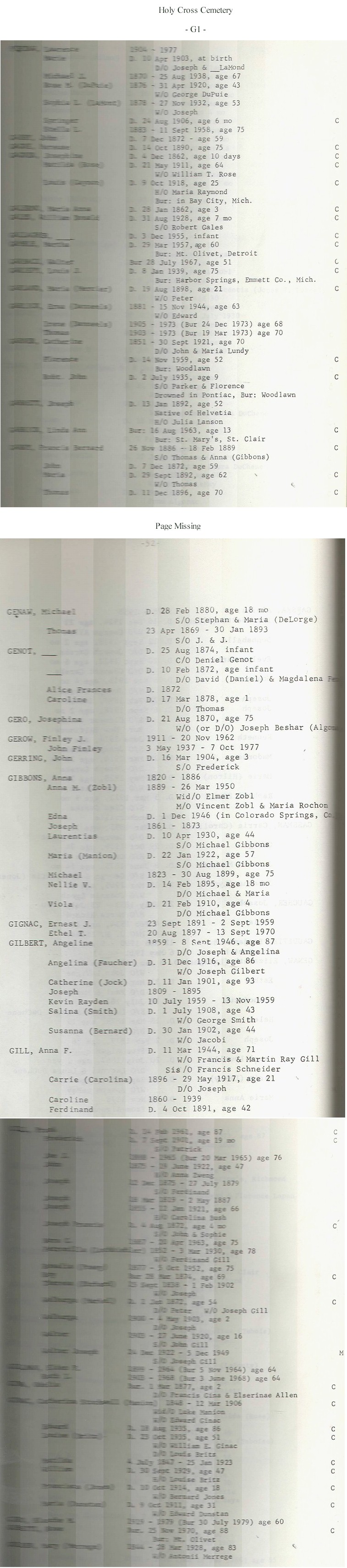
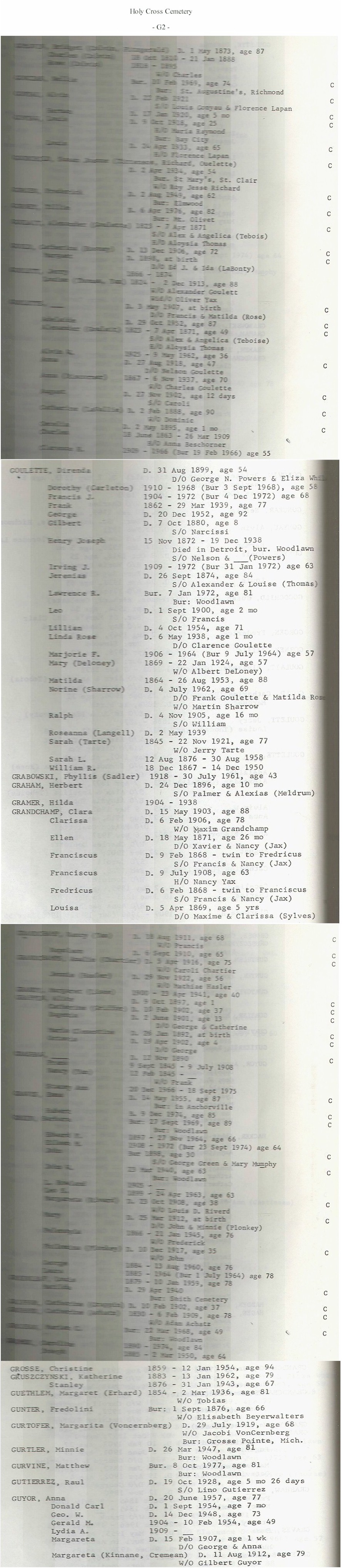
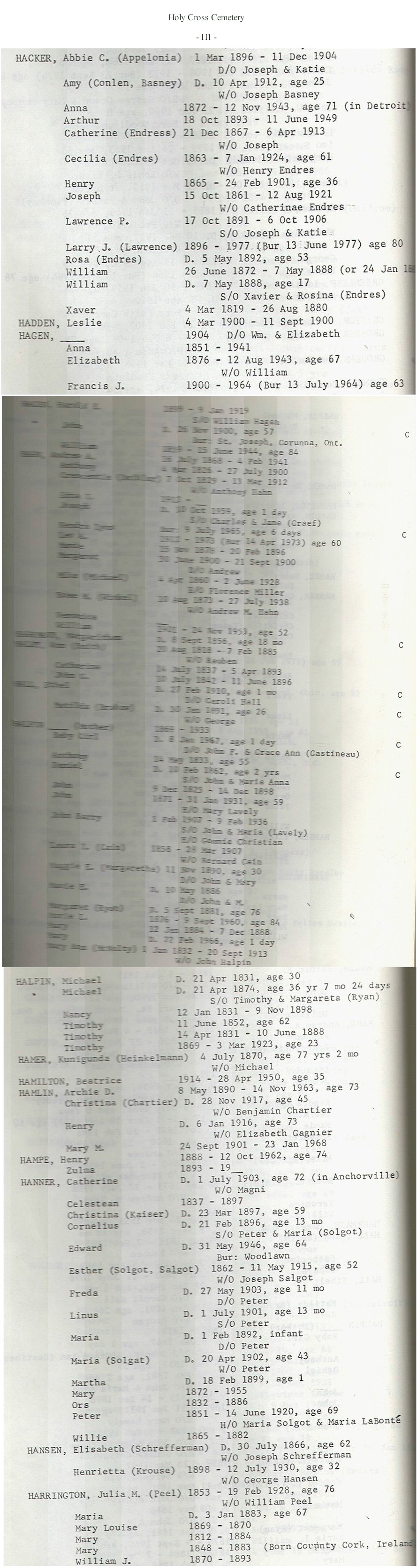
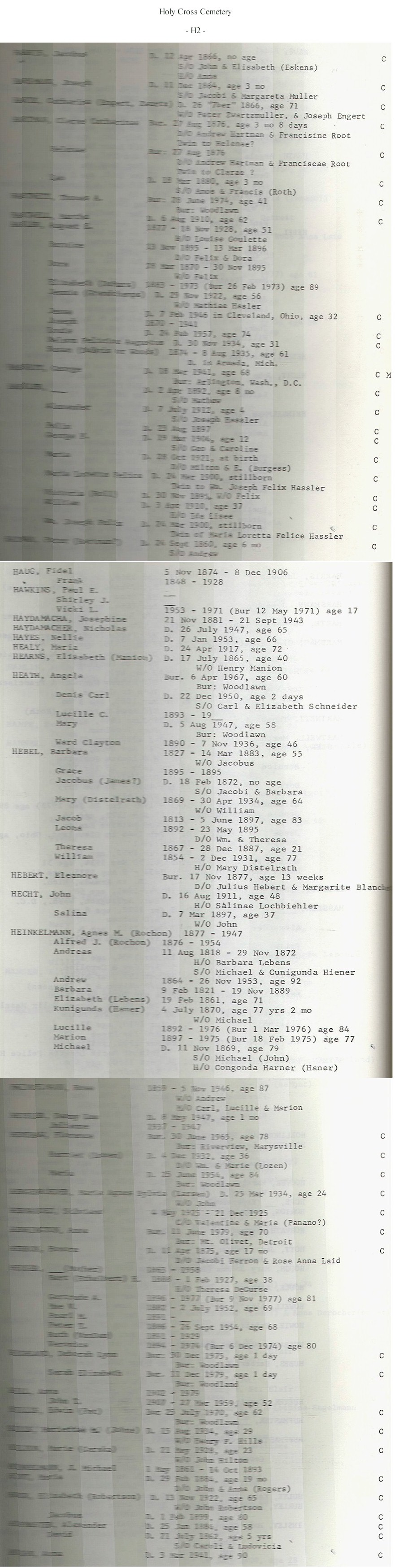
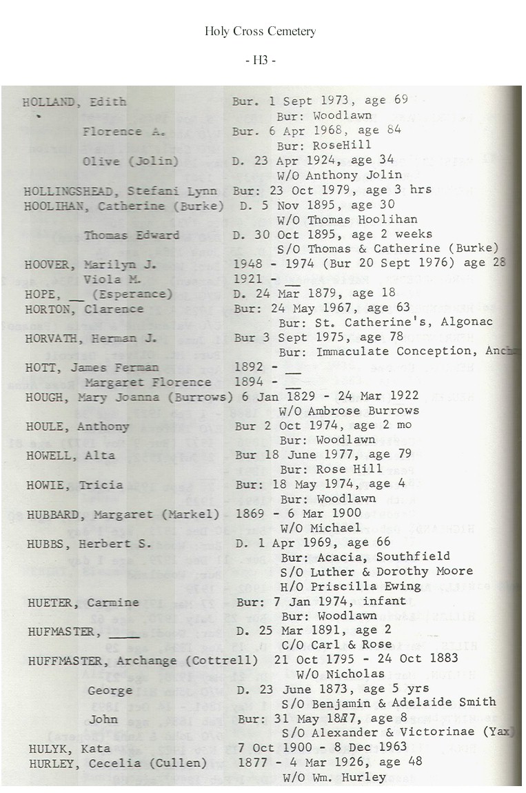
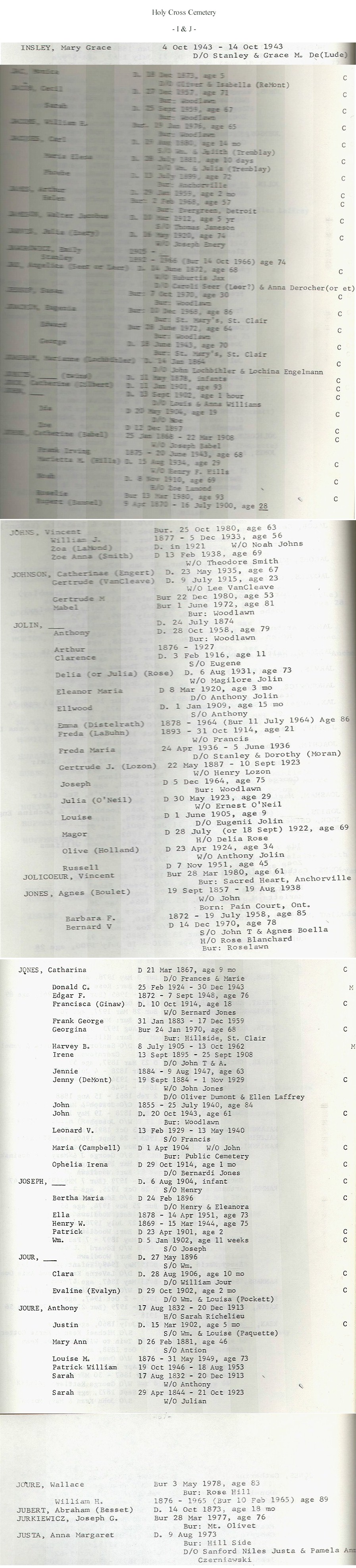
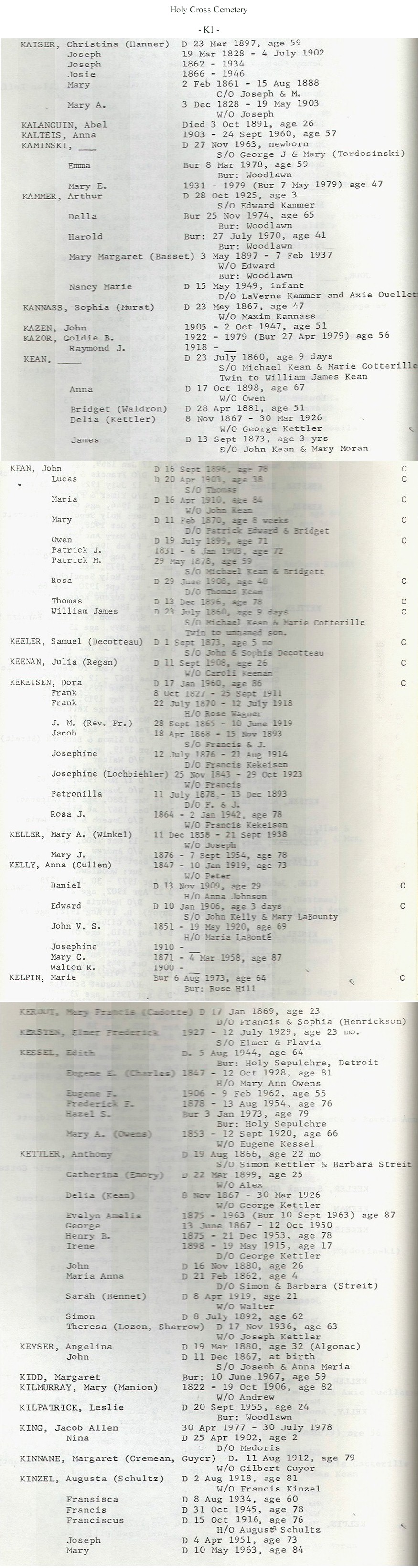
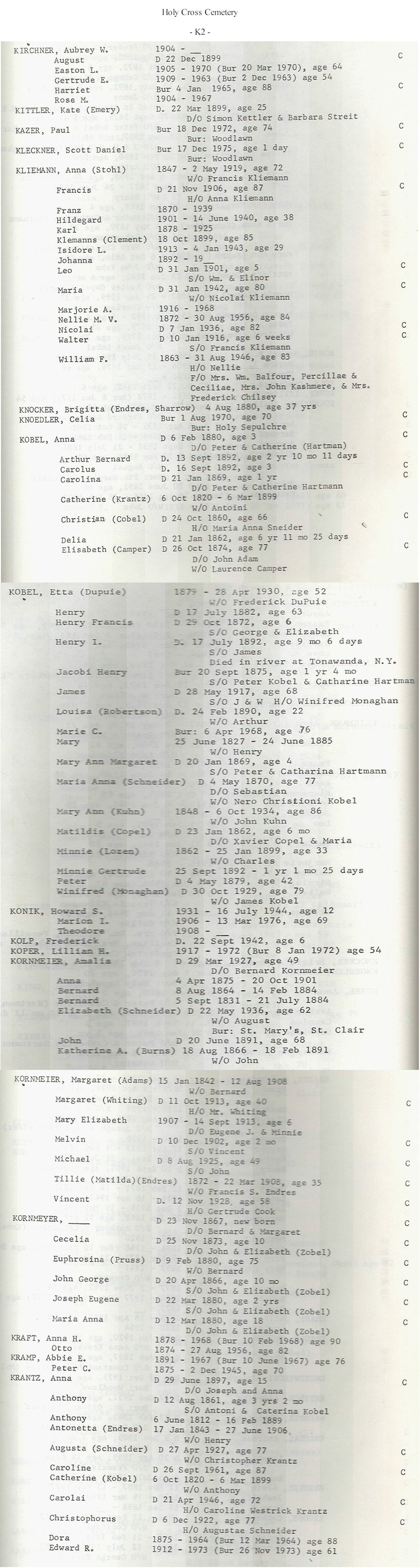
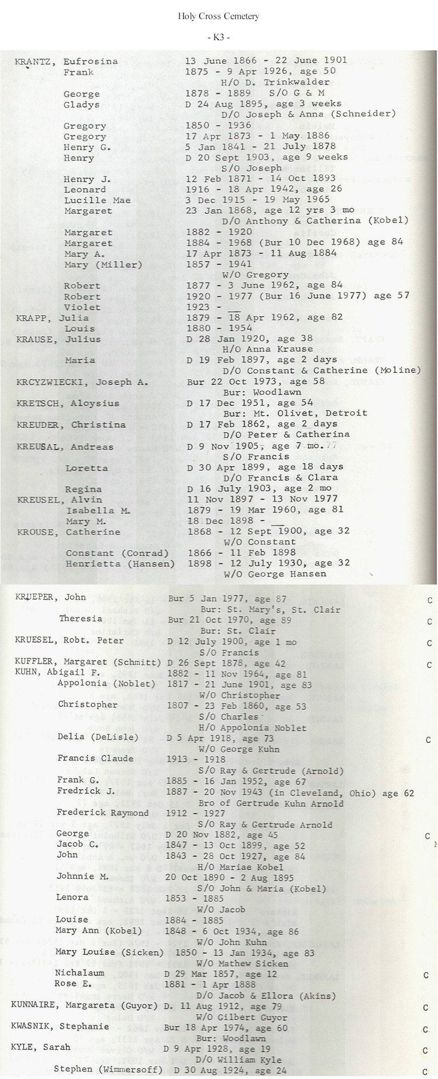
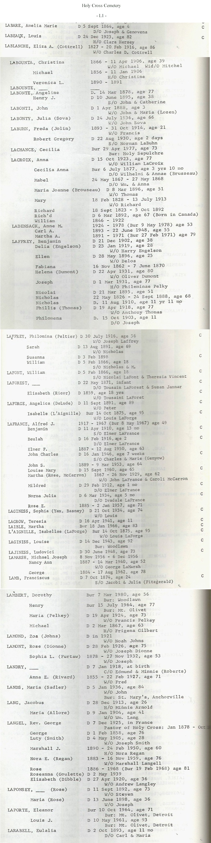
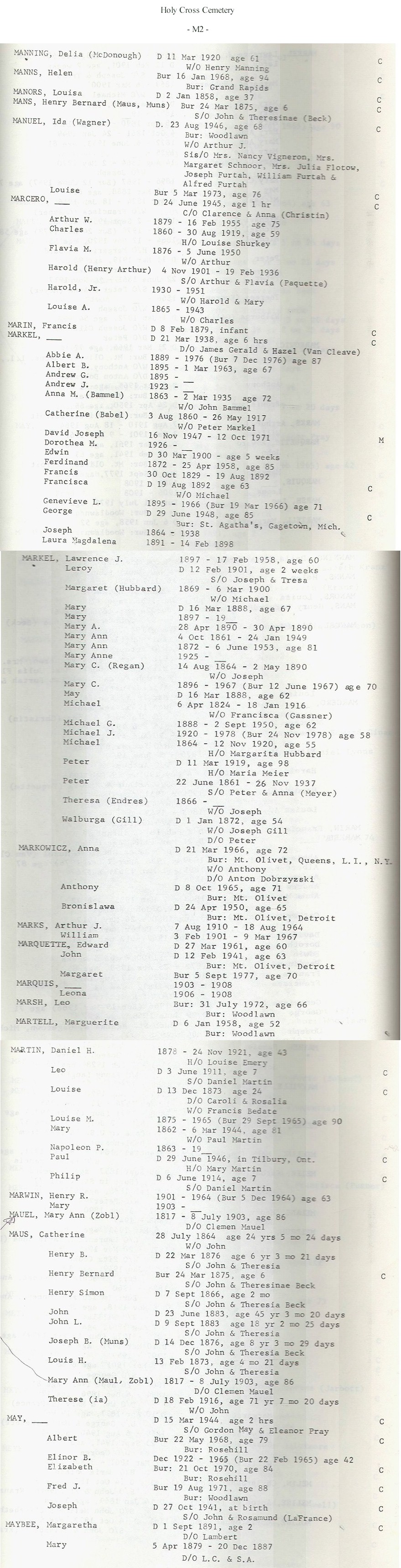
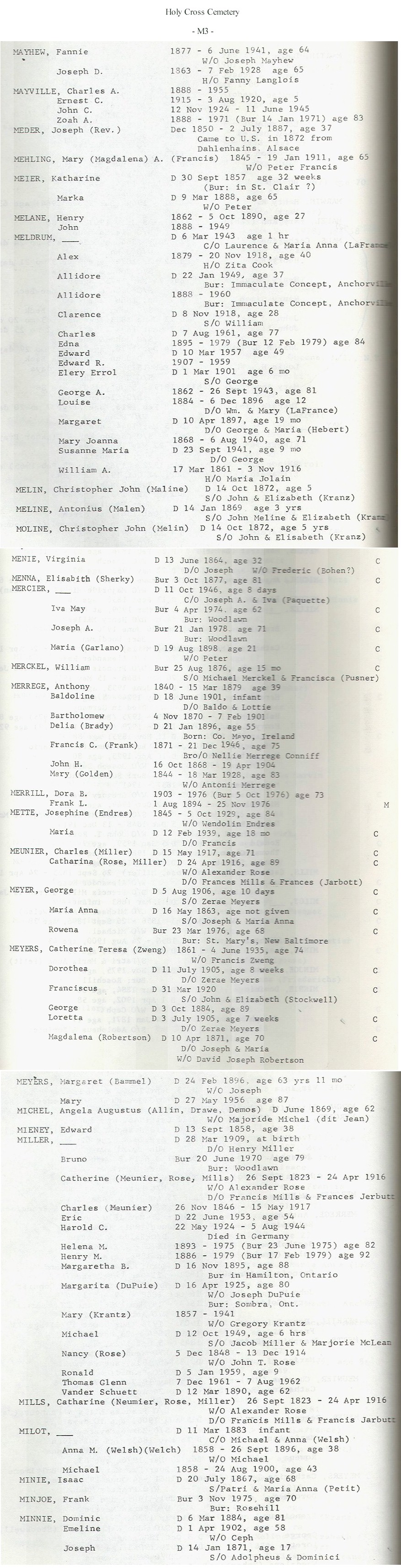
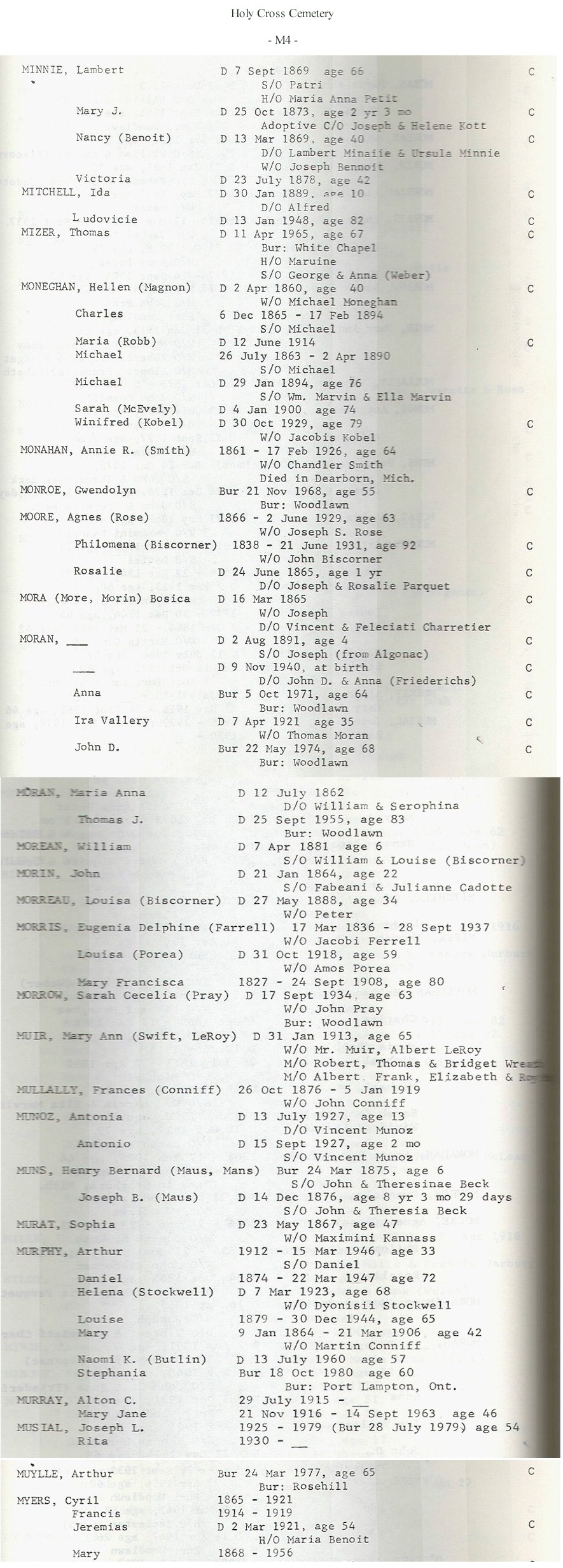
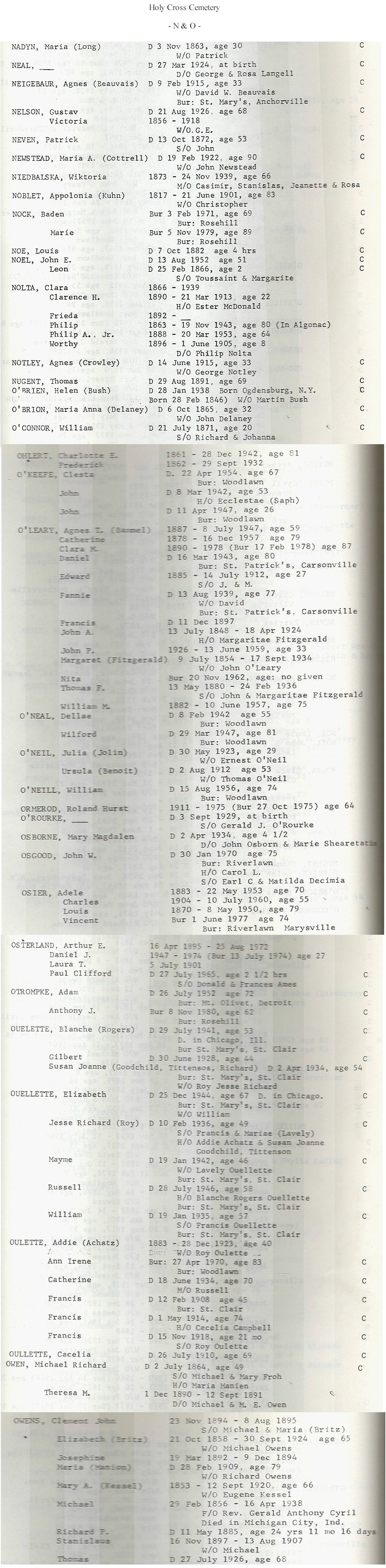
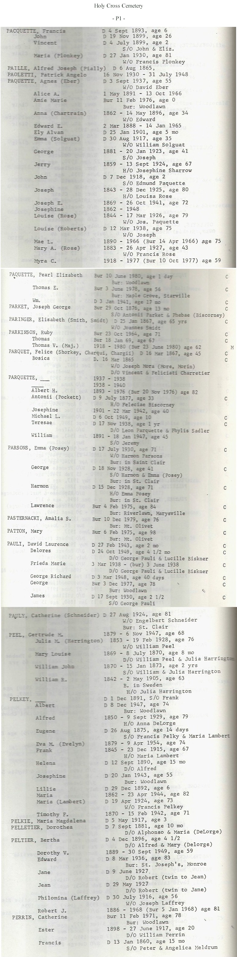
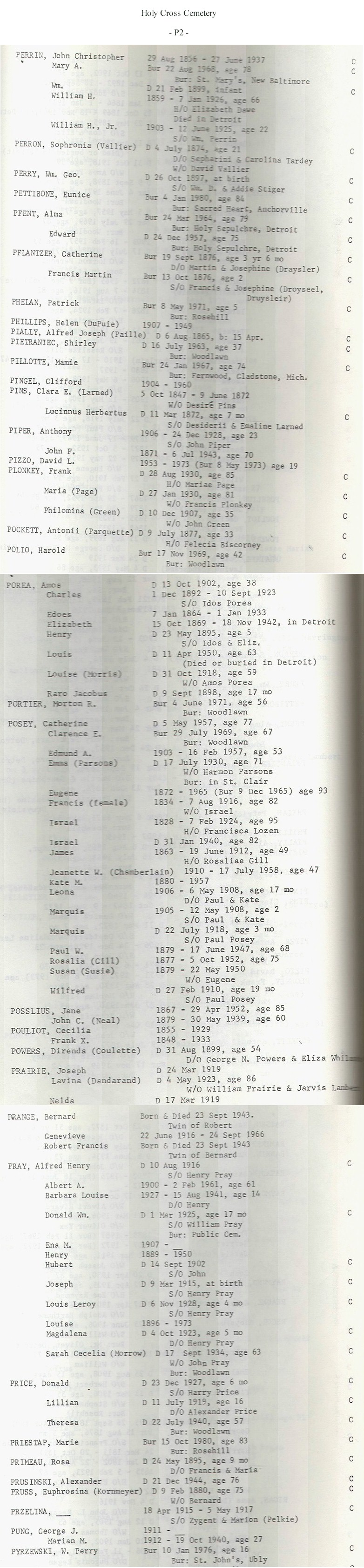
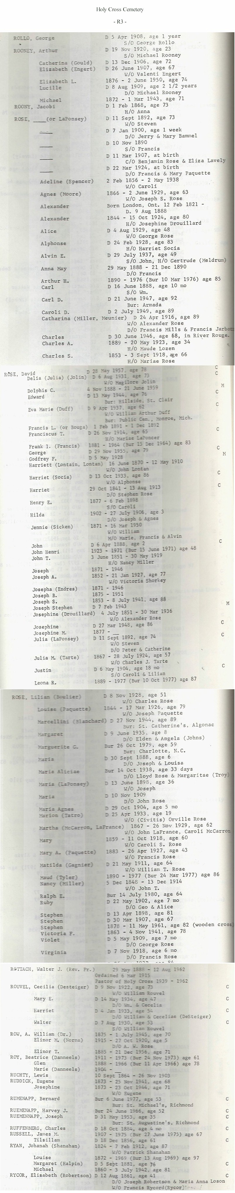
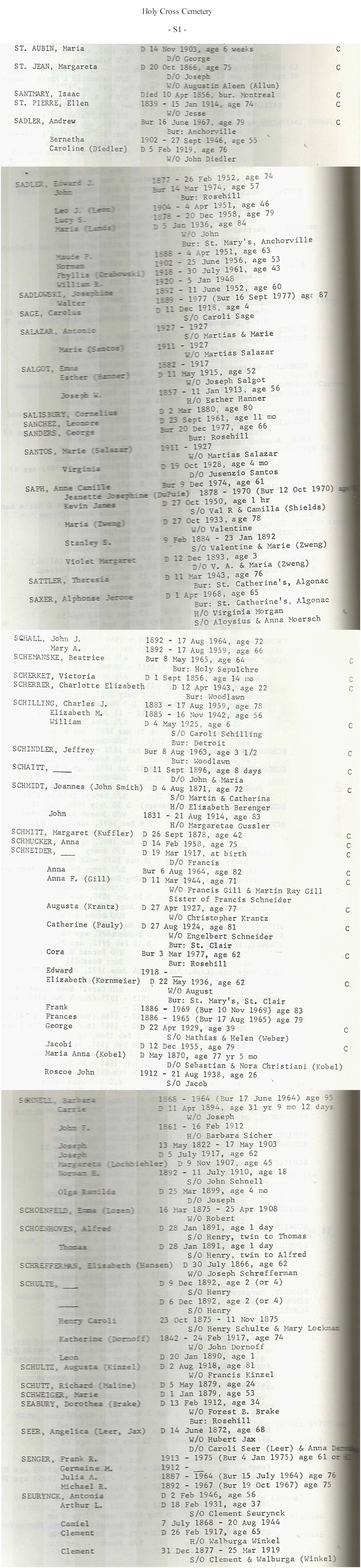
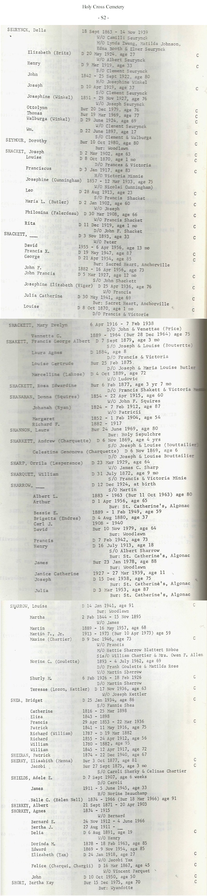
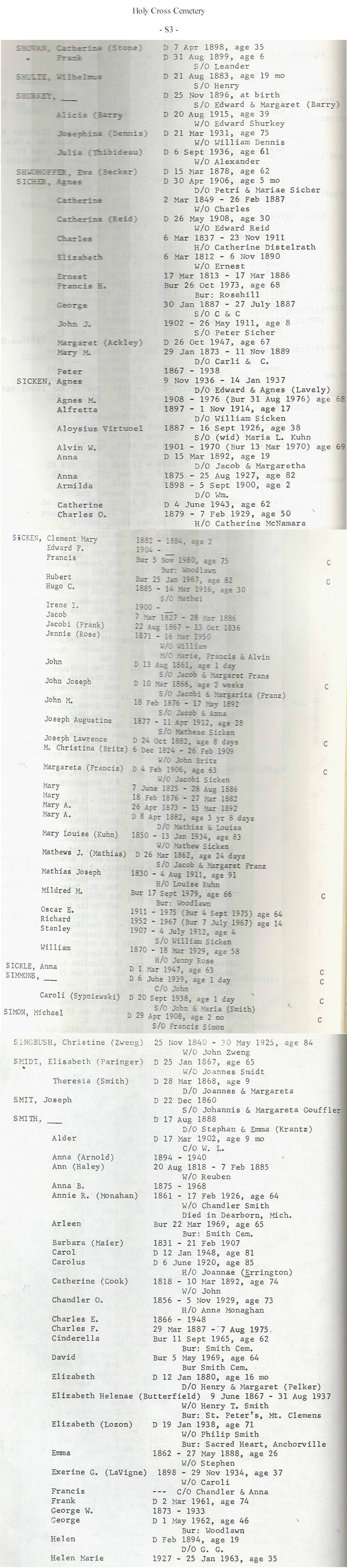
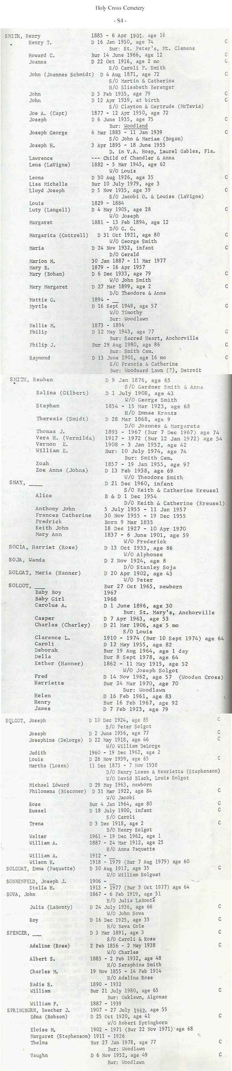
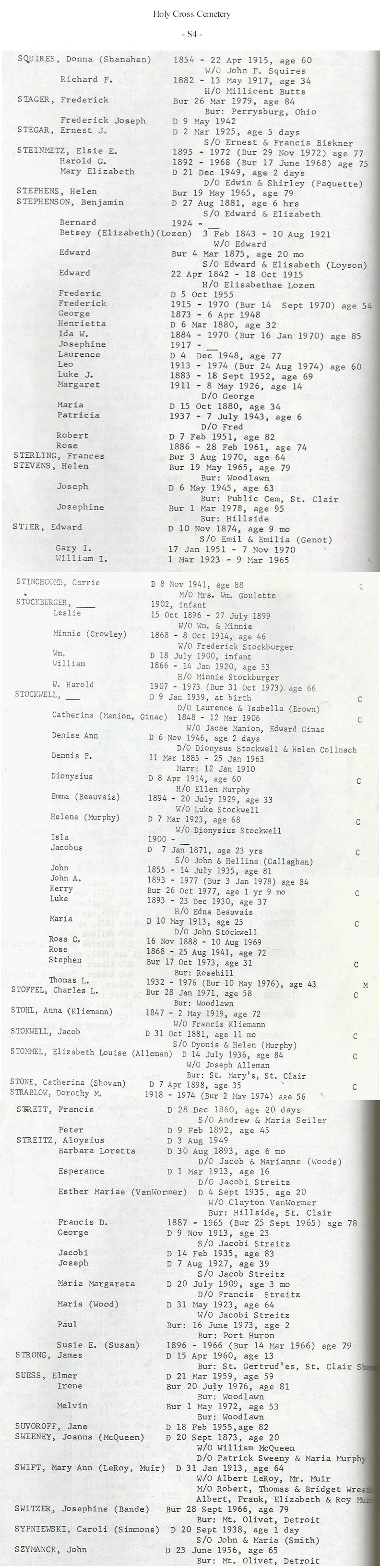
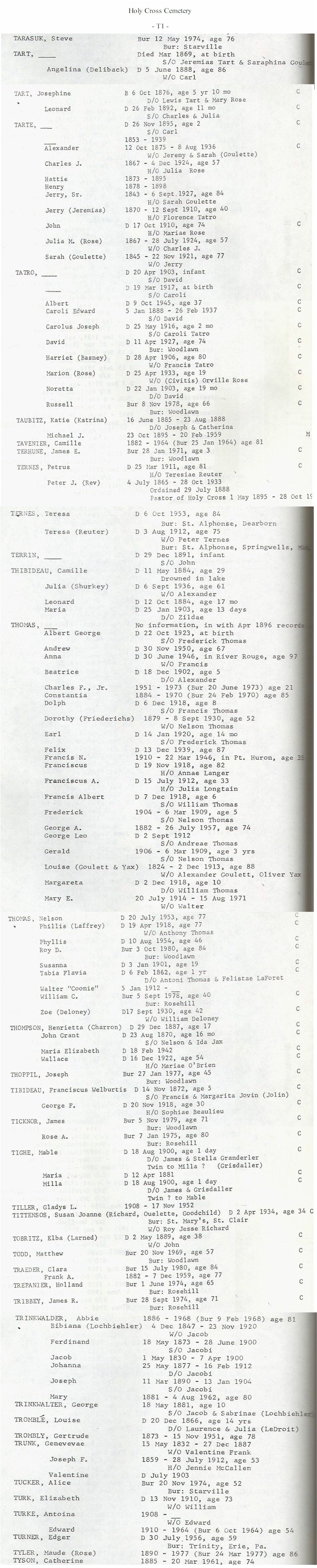
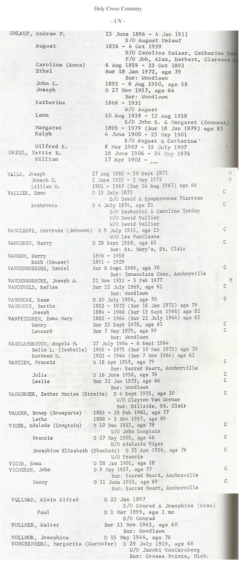
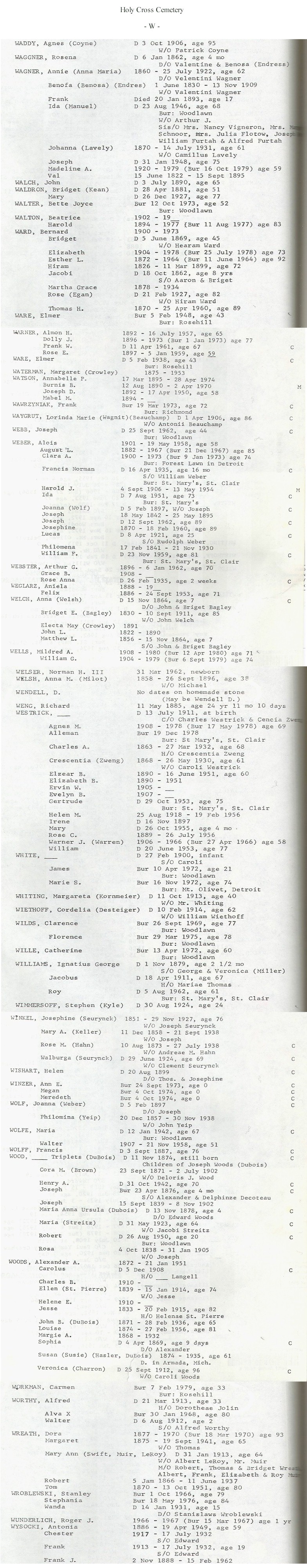
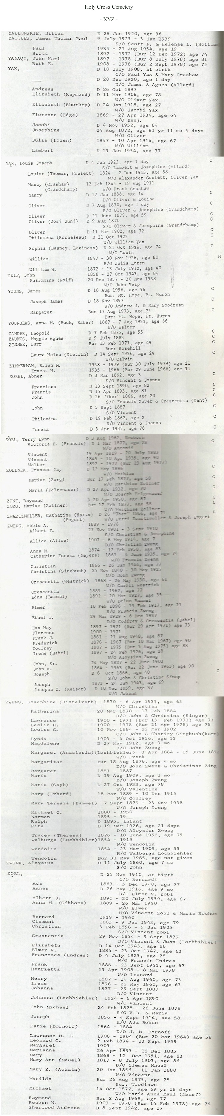
Holy
Cross Cemetery:
Parish-owned private cemetery, in current use and well-maintained.
In the city of Marine City, on Chartier St. at SE corner with King Rd.
Holy Cross Catholic Church,
610 S. Water St. Marine City MI 48039, (810) 765-3568
Introduction
|
A |
B1
|
B2 |
B3
|
B4 |
B5
|
B6 |
C1
|
C2 |
C3
|
D1 |
D2
|
D3 |
D4
|
E |
F1
|
F2 |
G1
|
G2 |
H1
|
H2 |
H3
|
IJ |
K1
|
K2 |
K3
L1
| L2 | L3
| L4 | M1
| M2 | M3
| M4 | NO
| P1 | P2
| Q | R1
| R2 | R3
| S1 | S2
| S3 | S4
| S5 | T
| UV | W
|
XYZ |
Find-A-Grave
Hoover Cemetery
(See East Berlin Cemetery)
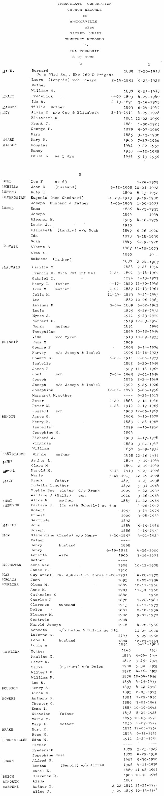
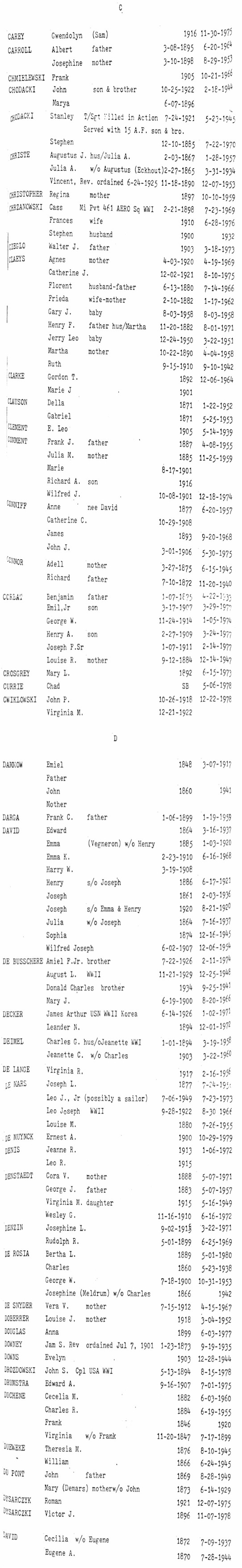
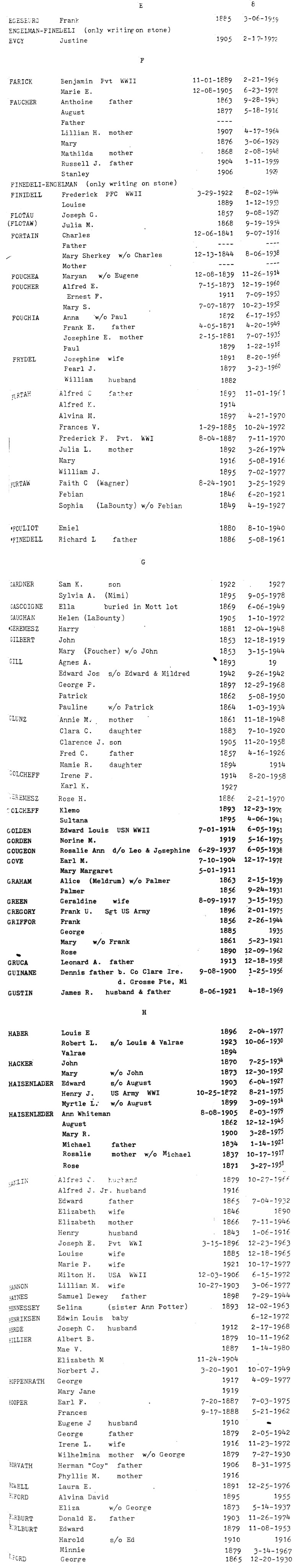
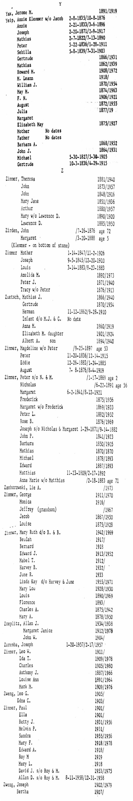
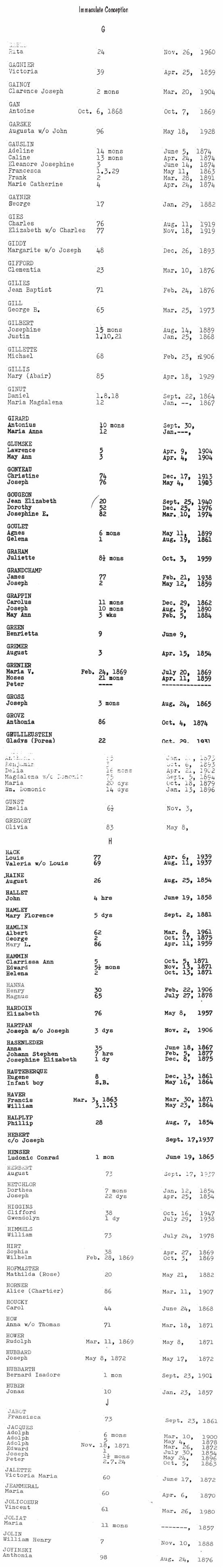
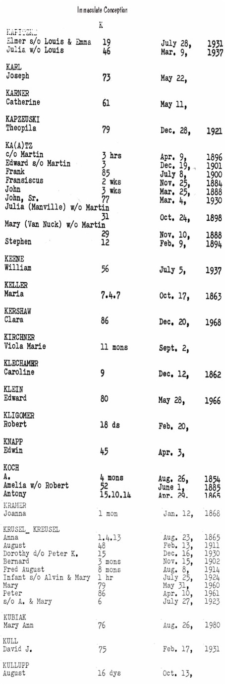
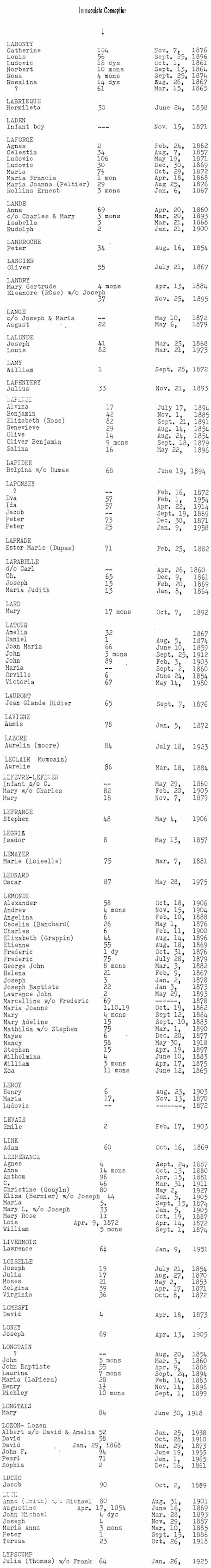
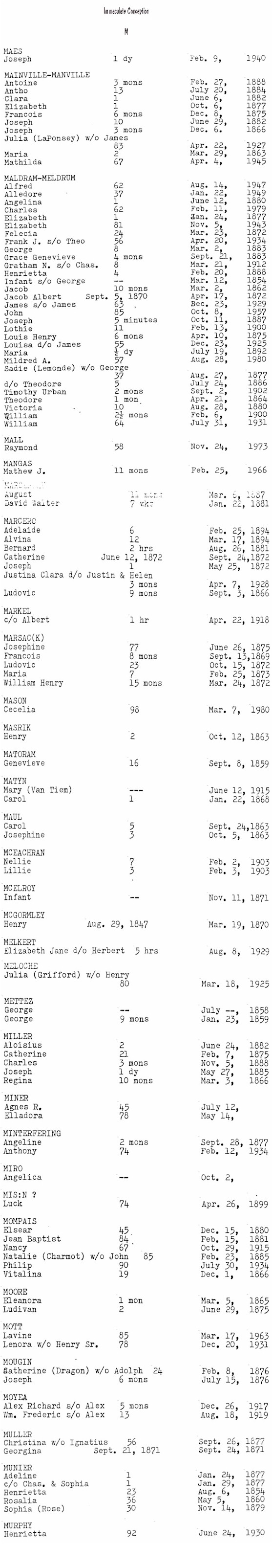
Immaculate
Conception Cemetery
(See St. Mary's Cemetery ~
Ira Township)
Irish Cemetery
(See St. Rose Cemetery)
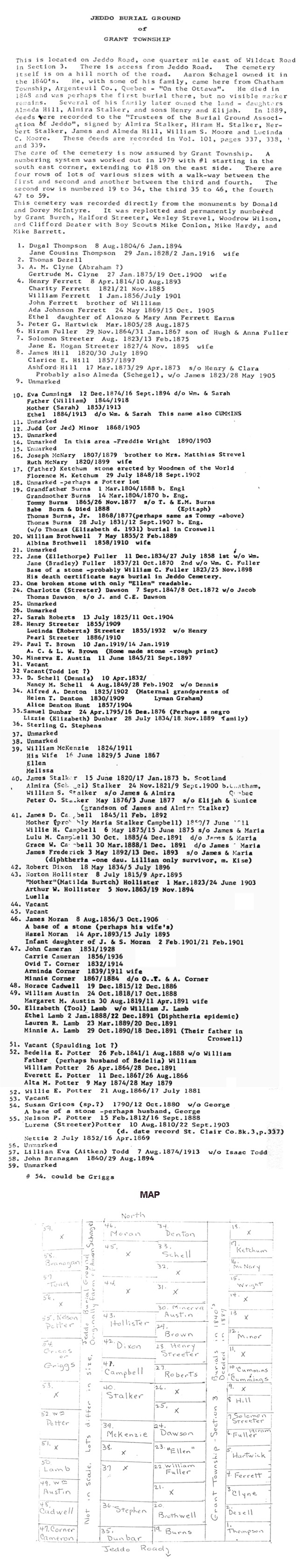
Jeddo Cemetery:
This cemetery is easy to miss; take your time as you drive along Jeddo Rd. It's on a hill north of the road, but first you park on the shoulder of the road, walk down a small grassy ravine, over an old rusty concrete bridge crossing the Burtch Creek, and then up the hill to the cemetery. Thanks to Gloria Reeves for finding this one. The grass had been cut recently, but many of the stones are hard to read or missing, and there don't appear to be any recent burials. Graves date from the 1850s, and include the following names, according to Debbie Russell: BURNS, CAMPBELL, HILL, POTTER, HOLLISTER and STREETER. Oldest marker was illegible. BURNS, died 1820. Most recent was STREETER, died 1997. Revisited by Debbie Russell in September 1999.
6204 Jeddo Rd.
S 1/2, Sec. 3, Grant Twp. 1/4 mile east of Wildcat Rd. on Jeddo Rd. On the north side of the road.
Find-A-Grave
Kenockee
Cemetery (See Our Lady of Mt. Carmel Cemetery)
Kinney Cemetery
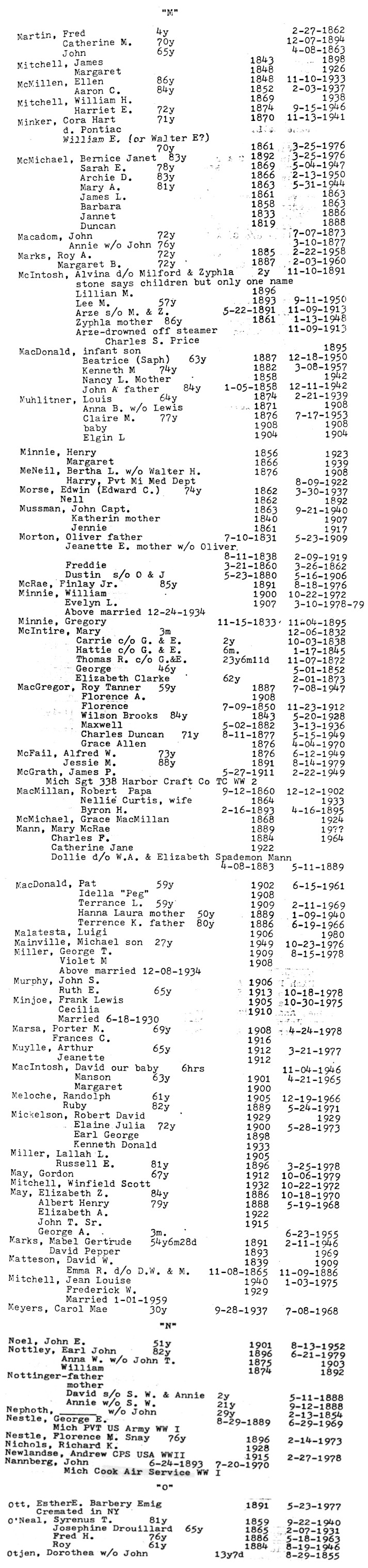
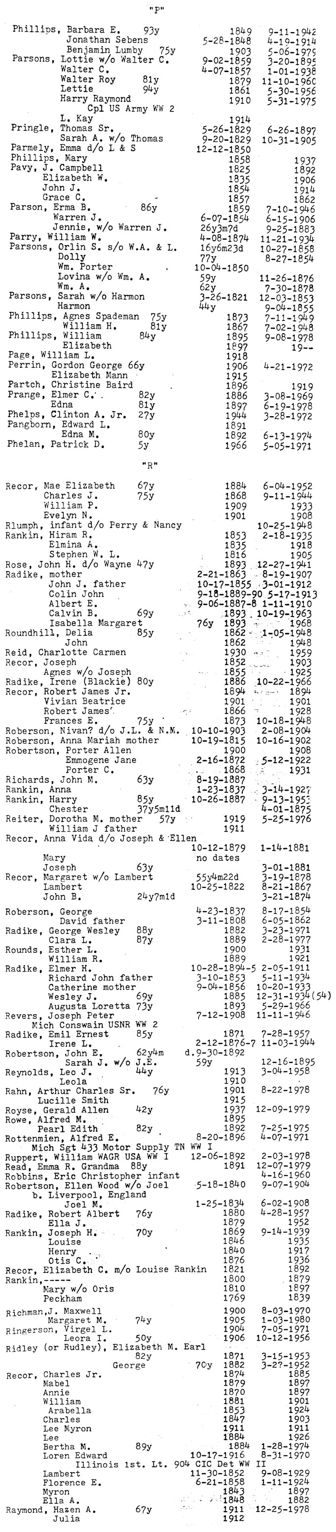
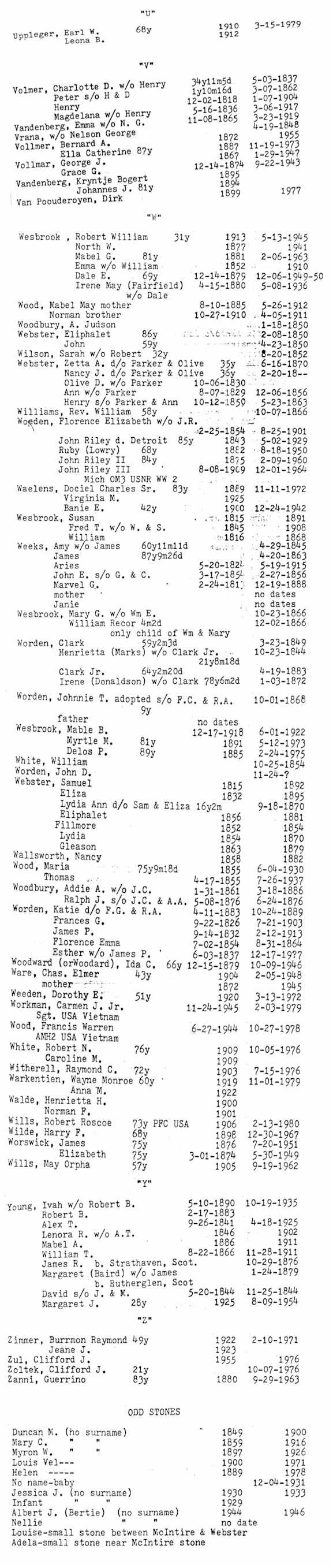
Database for Clyde Township Cemeteries
|
Find-A-Grave
This is a very pretty and well
kept cemetery outside of Port Huron. Go north on Wadhams Rd. and cross the Black
River. Immediately from your right only in comes North River Rd.; ignore it
and stay going north, as it turns left slightly Wadhams peels off to the right
and this is where the road becomes Vincent Rd. This is all
within about 1/8 of a mile, about 3/4 of a mile after this (or about 1 mile from
the river) Kinney Cemetery is on your left.
Kittridge Cemetery:
This is a fairly large cemetery, well-maintained and in current use. The oldest graves date from 1848 (William R.
STEUART). Newer graves are in the rear (east), oldest are in the SW corner. Visited in July 1999.
NW 1/4, Sec. 27, Columbus Twp. On east side of Werner Rd., just north of Gratiot Rd. Near ghost town of
Snyderville.
Find-A-Grave
Lakeport
(South Chapel) Cemetery:
Easily accessible and well-maintained, according to Kathleen
Conat. Revisited by Debbie Russell in September 1999.
Sec. 18, Burtchville Twp. On the west side of M-25 just north of the village of Lakeport.
Find-A-Grave
Lakeside
Cemetery:
In the city of Port Huron, at the intersection of Gratiot Ave. and Holland St. Across from Lakeside Park and Lake Huron.
Mt. Hope Catholic Cemetery is just north of
Lakeside. City-owned public cemetery, in current use and well-maintained. Includes Veterans Cemetery.
The city of
Port Huron now has maps
of the cemetery online, as well as a
searchable database of
burials in the cemetery. This database is an incredible resource, including
names of people buried in unmarked graves, the names of the grave owners in some
cases, and indigent burials. Kudos to the City of Port Huron for making this
resource available!
City of Port Huron
100 McMorran Blvd., Port Huron MI 48060
Cemetery office: At the rear of the cemetery, off Holland (810) 984-9709
Information & plot purchases: (810)984-9725
Cover Sheet |
Database
|
Find-A-Grave
There was a cemetery in Port
Huron known as Pinewood Cemetery. The city decided the cemetery land would be
put to better use if the cemetery was relocated, and the project was undertaken
during the late years of the 1800s. And so Lakeside Cemetery came to be the new
resting place of many who were formerly buried in Pinewood (they say they still
find bodies in Pinewood to this day when there is construction going on in the
area). Here are some newspaper articles about the
project, as well as names of the deceased who were relocated (not known to
be inclusive of all relocations).
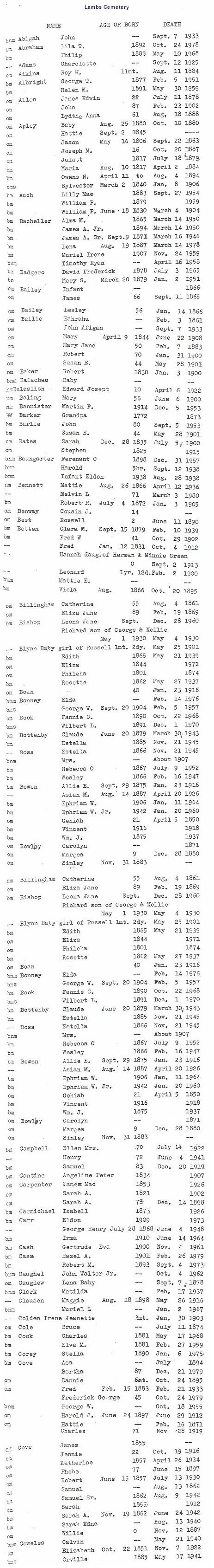
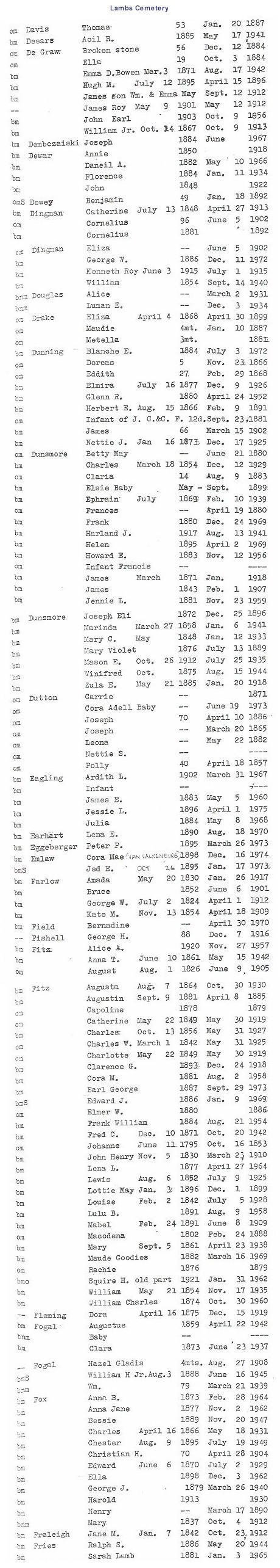
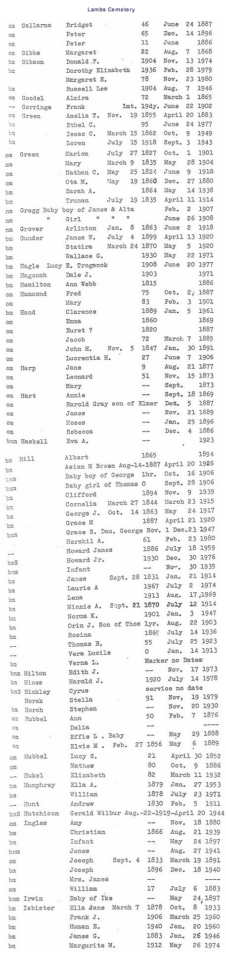
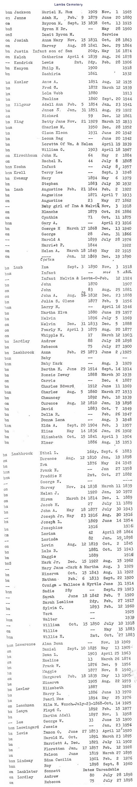
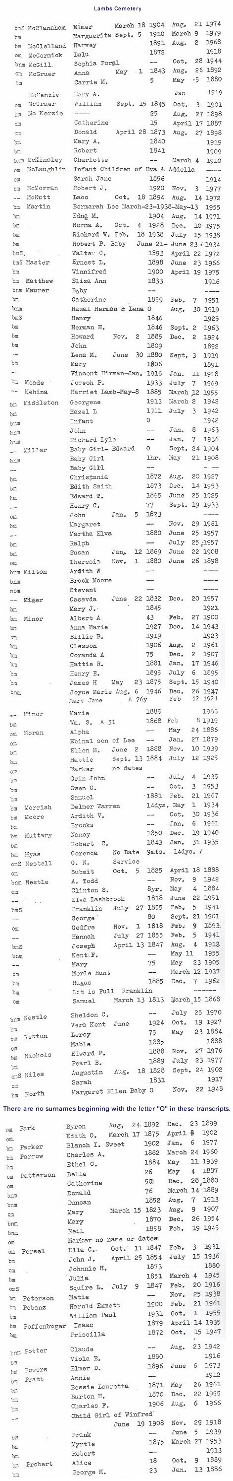
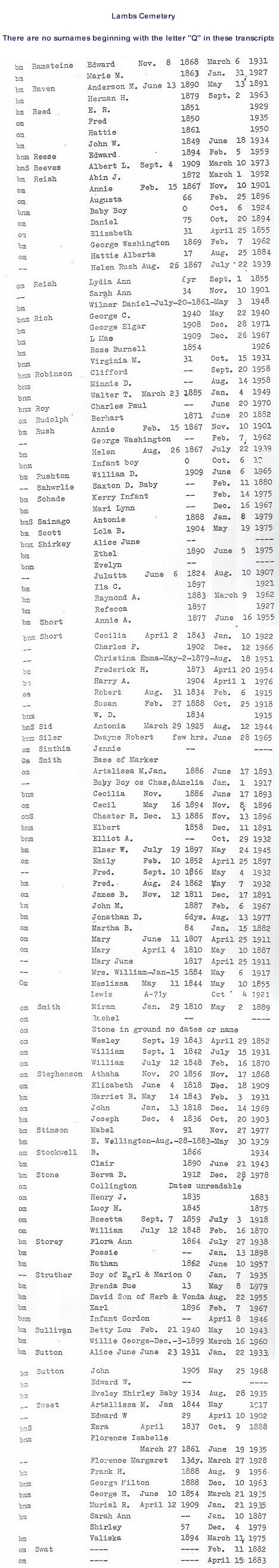
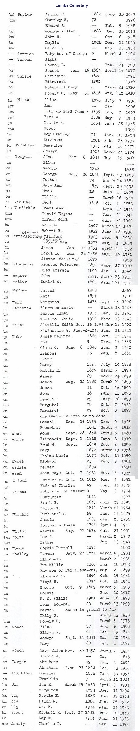
Lambs
Cemetery:
Across the street from Lambs United Methodist Church. The old stones are in bad shape; many are broken and unkempt, notes Melissa
Lashbrook. She suggests that researchers should go there soon, before the stones are any more illegible then they already are now. Visited in June 1999.
E 1/2, Sec. 20, Wales Twp. Just north of Lambs on Cove Rd.
Images: A-C | D-F
| G-I | J-L
| M-P | Q-S
| T-Z |
Find-A-Grave
Notes on images: B - in record book; M -
marker; N - no marker; OM - old marker; OMS - old marker in service
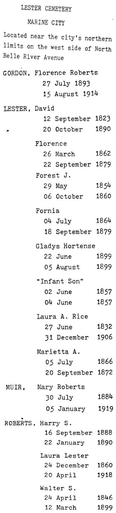
Lester Cemetery:
Suzanne Frantz and her husband visited this cemetery in November of 1999. Suzanne reports that it is a very small private cemetery located on North Belle River Road by the north Marine City limits. Belle River is right across the road. There is a high fence around the cemetery over-grown with vines. She could not see a way to enter.
Listed on the map printed in the Times Herald, 20 Aug 1995, from information provided by the St. Clair County Family History Group.
Cottrellville Twp., on Belle River Rd. north of Degurse St.
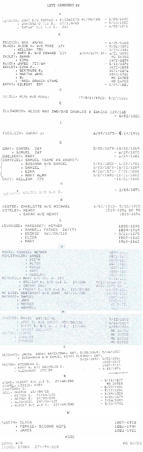
Lett Cemetery:
The cemetery has a large gate and a sign reading "No Trespassing. Greenwood Twp." The grass had been mowed, but there was no evidence of recent burials from outside the fence. Visited in July 1999.
Township of Greenwood,
9025 Yale Road,
Greenwood, MI 48006, (810) 387-4044
S 1/2, Sec. 6, Greenwood Twp. East of Cork Rd. on Beckett Rd. On the south side of the road.
Find-A-Grave
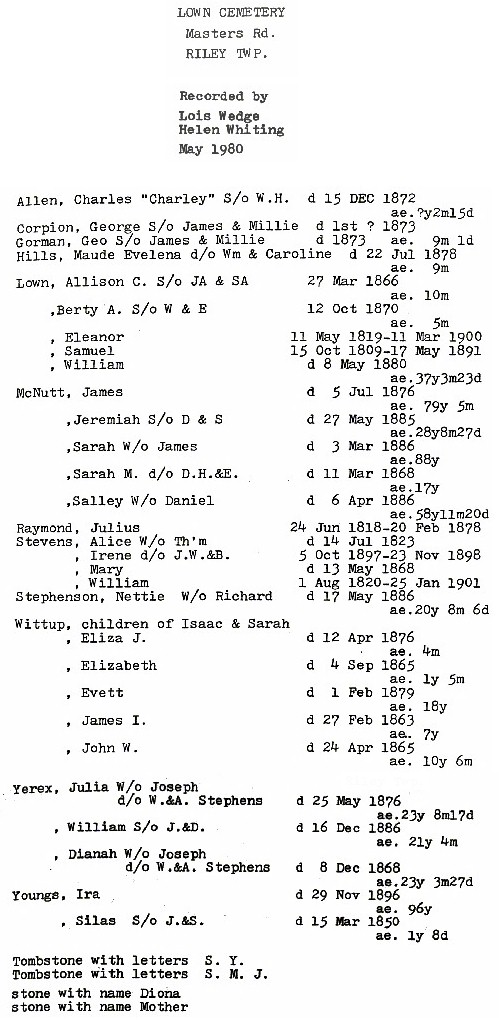
Lown Cemetery:
Kathy Stocki tells us that this is a very old and neglected cemetery. The only landmark of the cemetery are the old cement steps going up the hill to it, which are hard to spot. The area is very overgrown. There is a stone overturned at the top of the steps. Kathy saw four
"tablet" style markers, all lying on the ground, and three bigger markers still standing. The graves date from the mid-1860s. Some of the names include McNUTT, STEPHENSON and WITTUP. Andy Maturen, who also visited the site this summer, says there are probably 20 or so very old graves, dating from about 1850 to the early 1900's. Most of the graves are of Andy's ancestors, the LOWNS and McNUTTS, including great-grandparents James and Sarah McNUTT. Kathy doubts that the cemetery has been in use in the 20th century, and it has been largely absorbed into the surrounding landscape. Visited in August 1999.
NW 1/4, Sec. 20, Riley Twp. About 1/2 mile east of Riley Center on the south side of Masters Rd., before the Belle River bridge.
Lutheran
Cemetery (See
Greenwood Cemetery):
Suzanne Frantz, with her husband, walked the Evangelical Cemetery on November 20, 1999. Although they did not walk the Lutheran Cemetery across the road (south side), they report that it appears to be it good condition.
Find-A-Grave
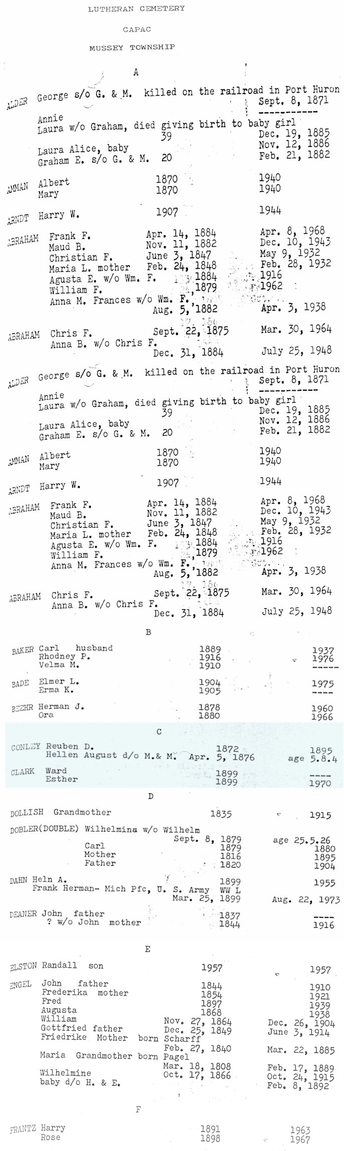
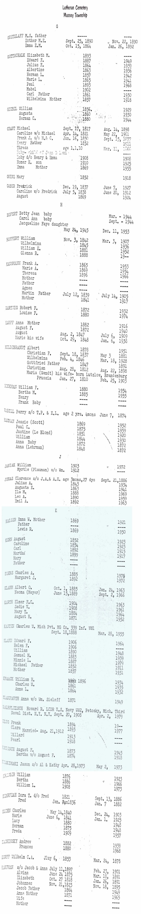
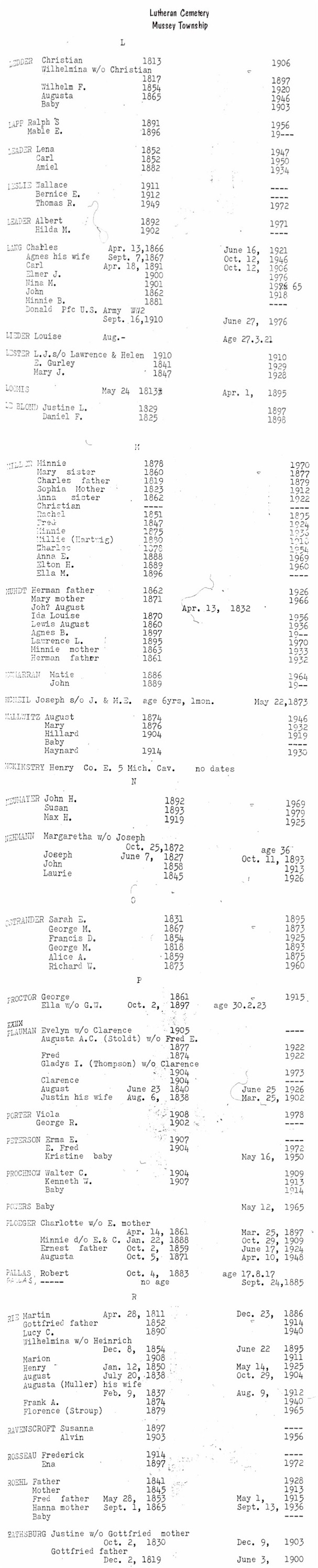
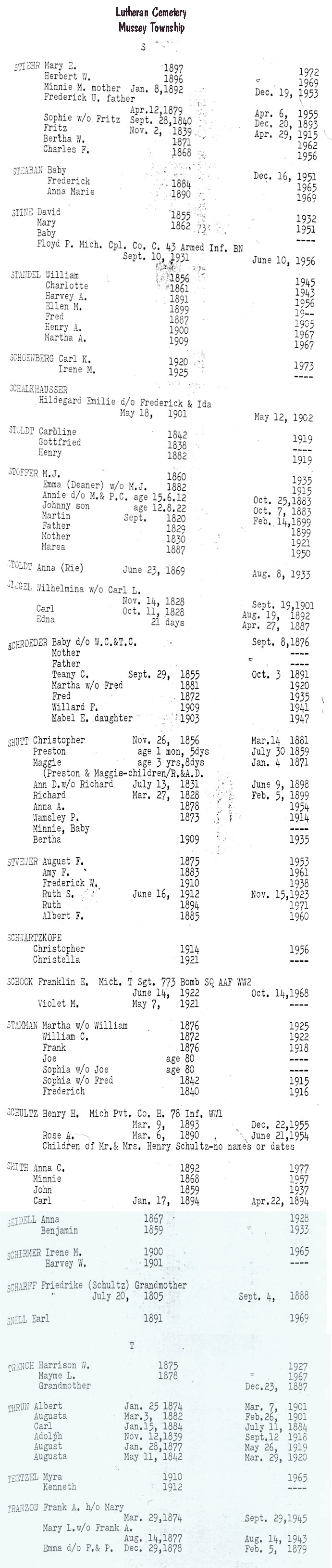
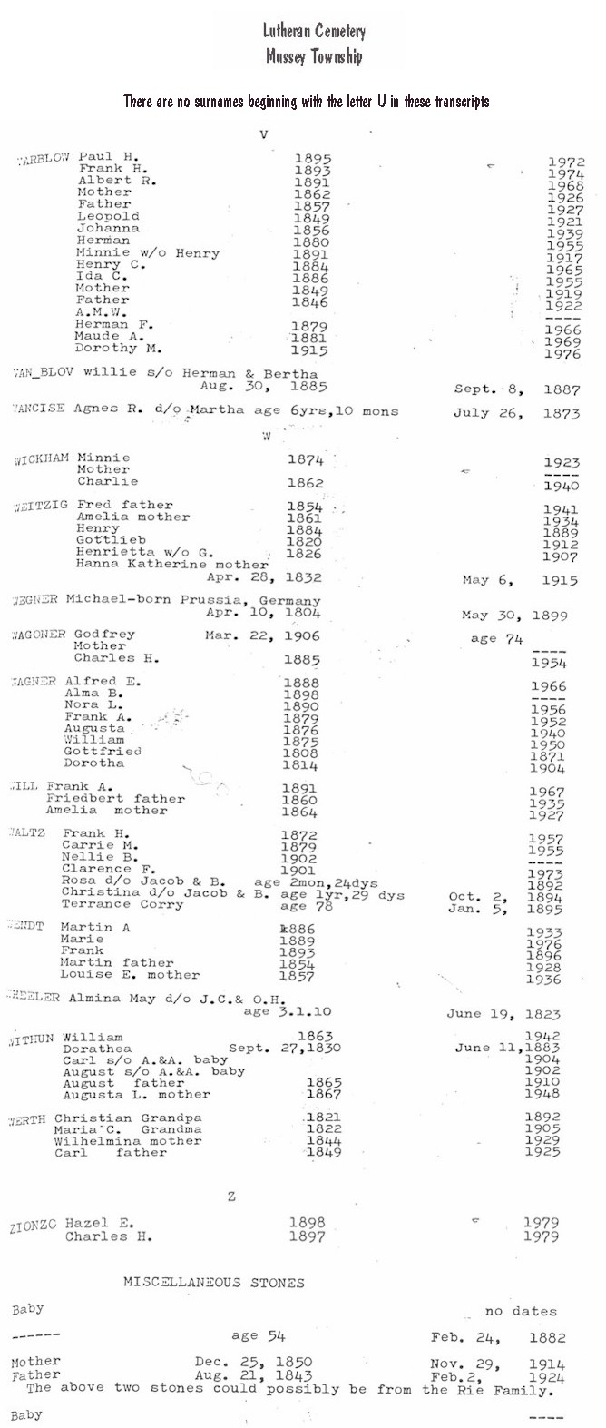
Lutheran
Cemetery (Mussey Township Cemetery):
Listed on the map printed in the Times Herald, 20 Aug 1995, from information provided by the St. Clair County Family History Group.
Capac, Mussey Twp., on Imlay City Rd.
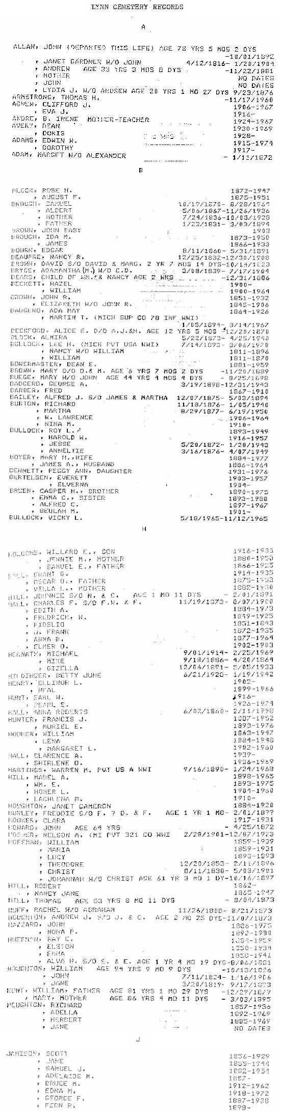
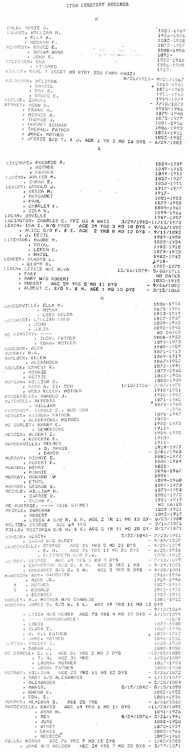
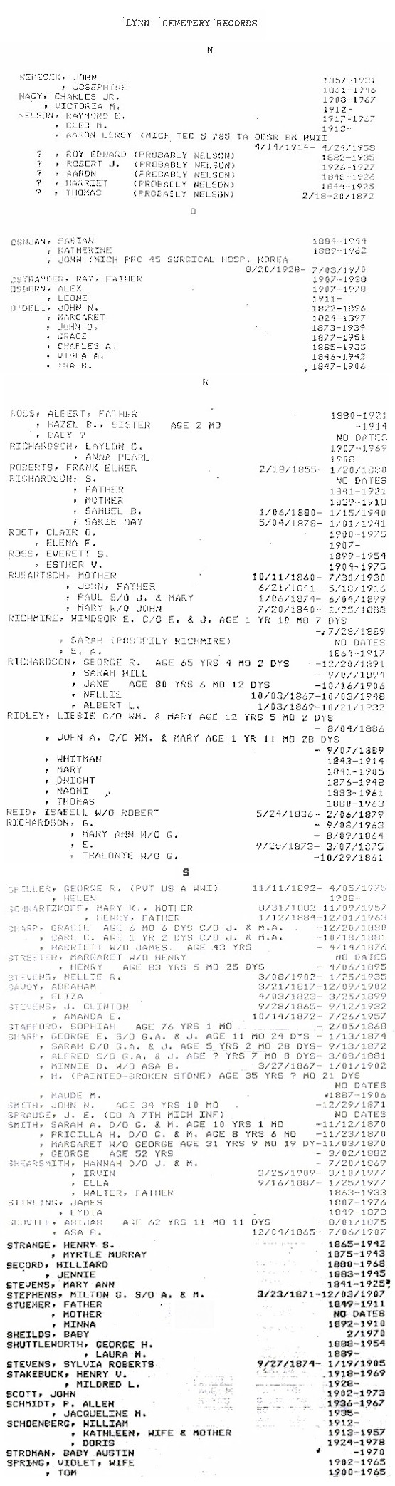
Lynn Township Cemetery:
The cemetery was well-maintained and in current use when visited by Tom Kephart in July 1999. Graves date from the early 1860s.
Township of Lynn,
15819 Dudley Road,
Brown City, MI 48416-9511, (810)346-3198
NE 1/4, Sec. 27, Lynn Twp. On the west side of Sterling Rd., north of the Norman Rd. intersection.
A-J |
K-M |
N-S |
T-Z |
Find-A-Grave
Mack's Cemetery:
Listed on the map printed in the Times Herald, 20 Aug 1995, from information provided by the St. Clair County Family History Group. Debbie Russell wonders if this might be Riverlawn Cemetery, since that cemetery backs up to the golf course in Marysville on the old River Rd.
Years ago Lois Wedge was heavily involved in getting
the cemetery records transcribed. She recently sent me this note about Mack's
Cemetery:
"Mack Cemetery Is a
private cemetery that was owned by Andrew Mack. When the Golf Course was
built, they found the tombstones of Andrew and his wife Amelia. Andrew Mack
was one of the first settlers in Marysville. It was on his property."
Lois Wedge
In the city of Marysville, reportedly on the golf course.
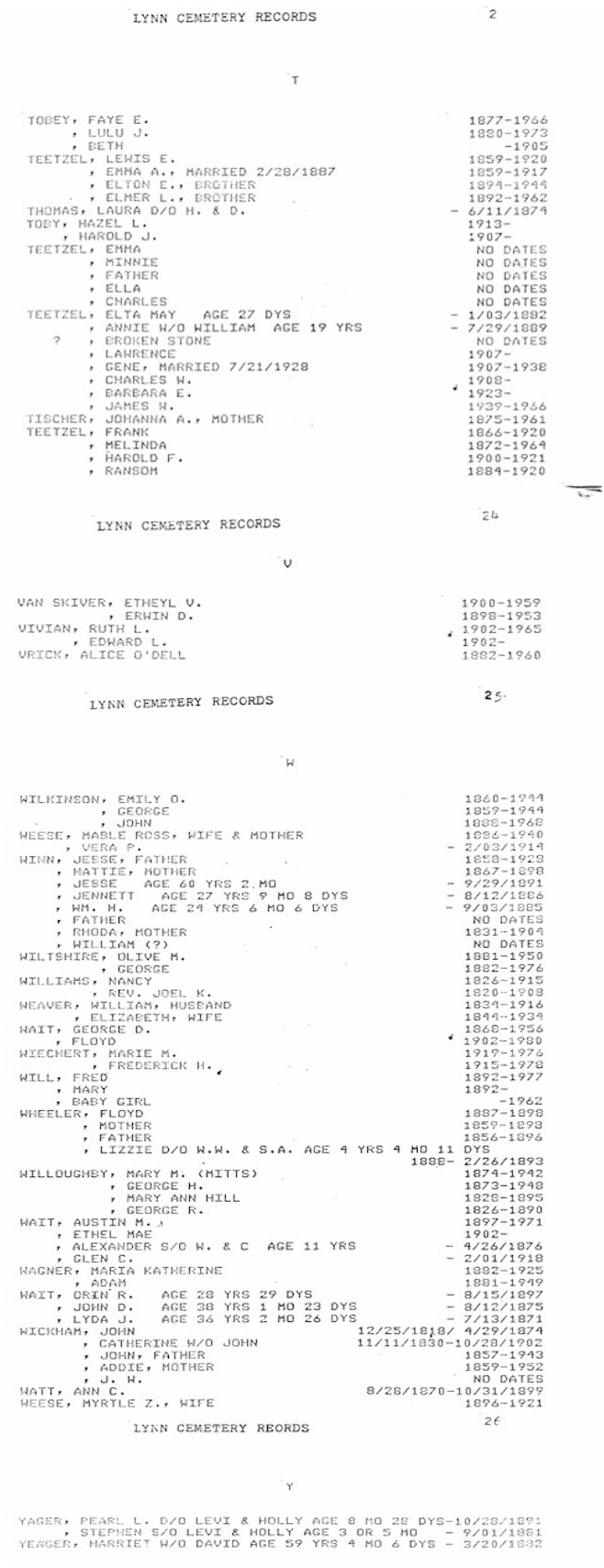
Mallory Cemetery:
Listed on the map printed in the Times Herald, 20 Aug 1995, from information provided by the St. Clair County Family History Group.
Kimball Twp., Sec. 33, west side of Pine River Rd.
Maple
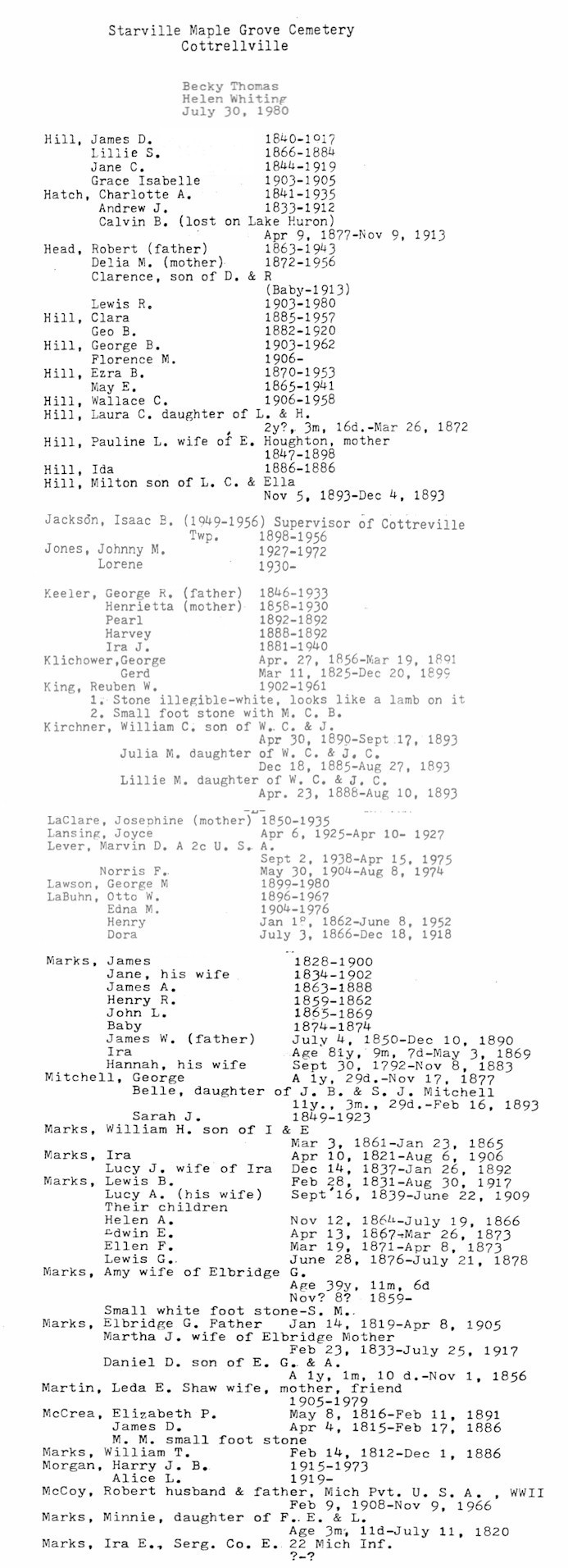
Grove Cemetery
(aka Starville Cemetery):
Debbie Smith Russell says this cemetery is active and well-kept.
On section line between Secs. 18 & 17, Cottrellville Twp., behind Starville Church.
A-G |
H-M |
O-Z
|
Find-A-Grave
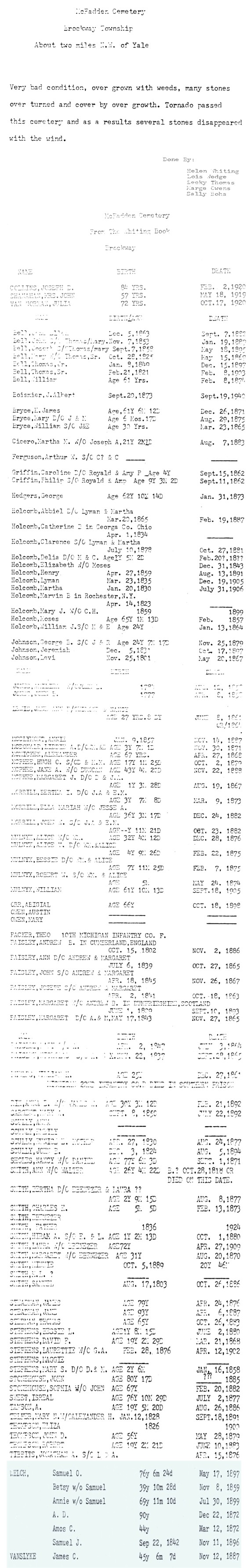
McFadden Cemetery:
Small, apparently private cemetery with a stone gate. No recent burials, and the existing stones are in various stages of disrepair and deterioration, although the grass had been recently mowed. Graves date from the 1860s. Many unmarked or no longer marked graves are evident. Visited in July 1999.
SW 1/4, Sec. 4, Brockway Twp. On the east side of Arendt Rd., north of Jeddo Rd.
Database
|
Find-A-Grave
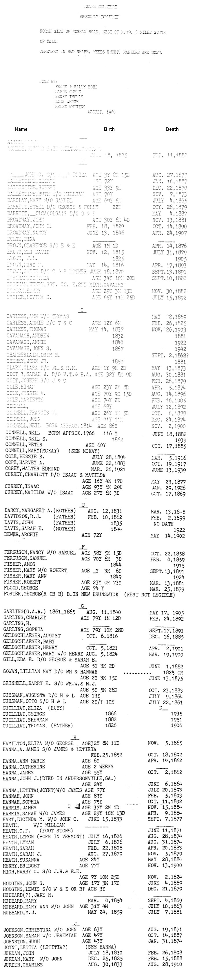
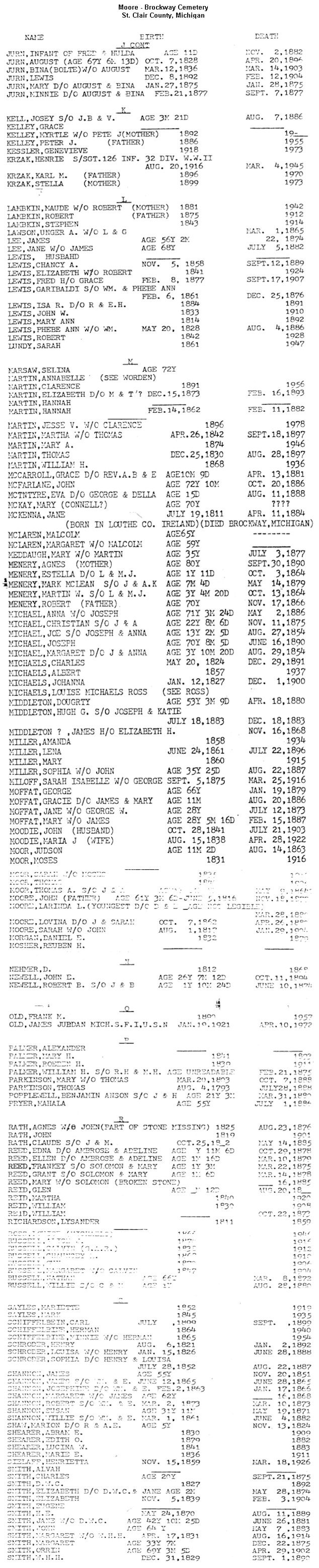
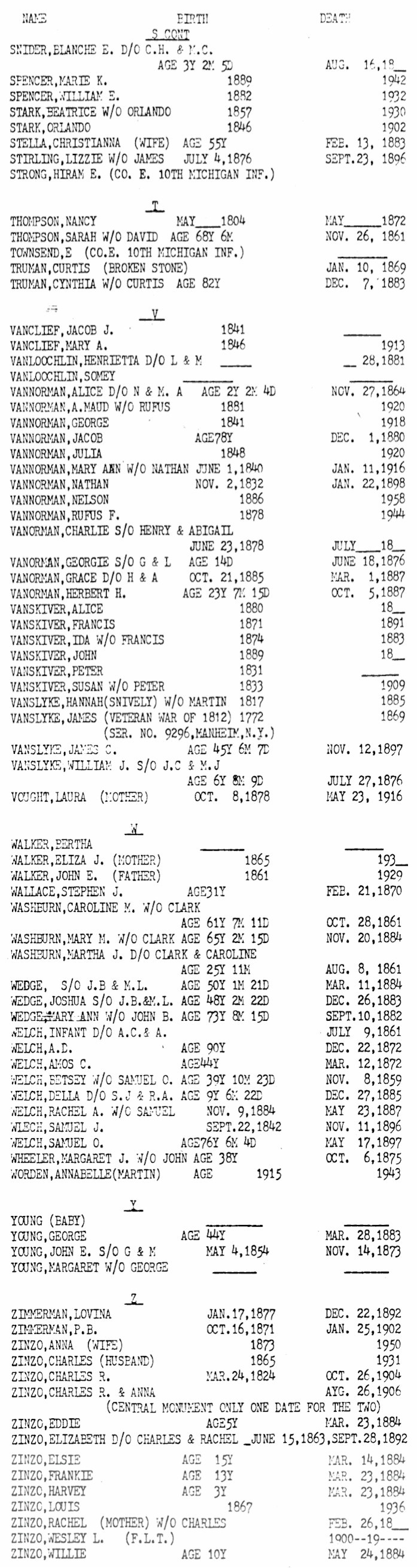
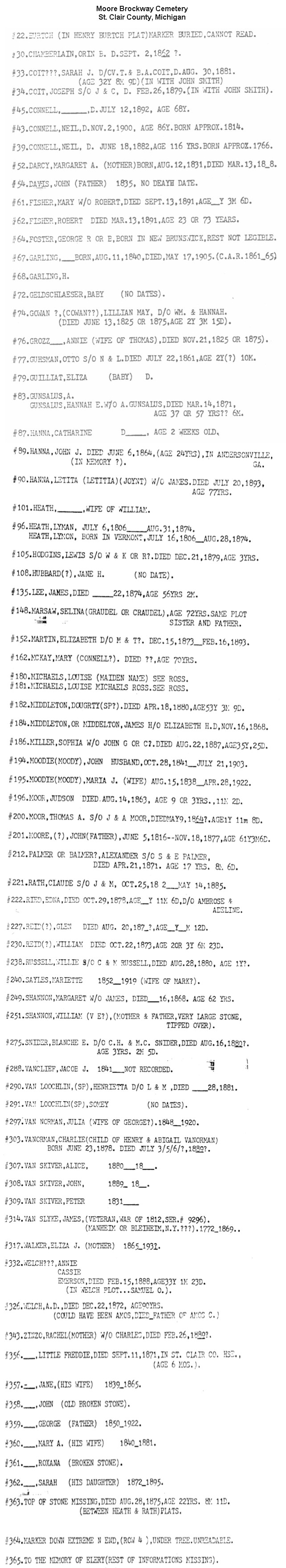
Moore
Cemetery
(aka
Brockway Cemetery):
Well-maintained private cemetery with a locked
gate. No recent burials were apparent from the road, but permission had not been obtained to enter the cemetery. Visited in July 1999.
Update November 2007, visitor Dan Houghtaling says the gate is not locked and
that there is a walk-through just to the right of the gate. Dan says, "I
was contacted by the Brockway Township supervisor (Carl Vermeesch) in response
to my query and he says the cemetery is open to the public and permission
is not required to enter it." Good news for those of you would like and are
able to visit the cemetery. Thanks Dan!
SE 1/4, Sec. 27, Brockway Twp. On north side of Norman Rd. east of Connell Rd.
A-J |
J-S |
S-Z |
Miscellaneous |
Database
|
Find-A-Grave
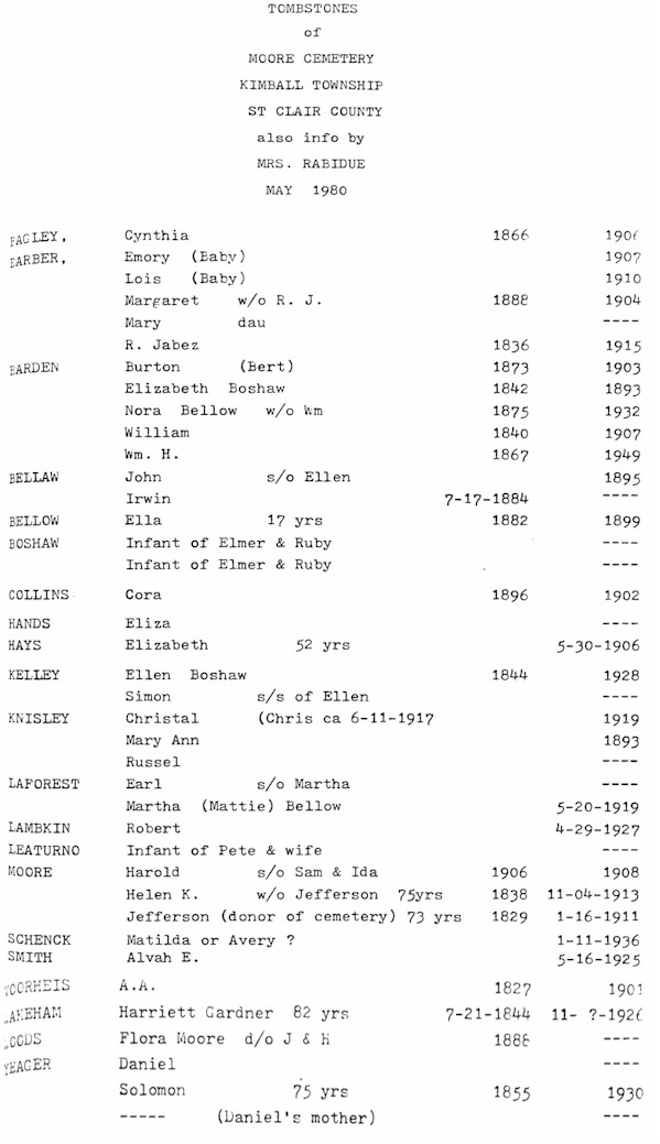
Moore Cemetery - Kimball
Township
Debbie Russell describes this one as about a 1/2 acre cemetery which is fenced and mowed. Most stones dated from the late 1890's to early 1900's.
Inactive. Visited in September 1999.
SW 1/4, Sec. 15, Kimball Twp., Northeast corner of intersection of Dove and Ditty
Rds.
Mt.
Hope Catholic Cemetery:
In the city of Port Huron, at the intersection of Gratiot and
Kraft Rds., north of the Black River Canal.
Private Catholic cemetery, in current use and well-maintained. City-owned
Lakeside Cemetery is just south of Mt. Hope.
1209 Kraft Rd.,
Port Huron MI 48060, (810) 985-5323 or (810) 984-2689
The following
databases are very large, so please be patient as they load
Mt. Hope Database
| Mt. Hope Death Records, Miscellaneous and
Children | Mt. Hope lots sold 1875 to 1896
|
Find-A-Grave
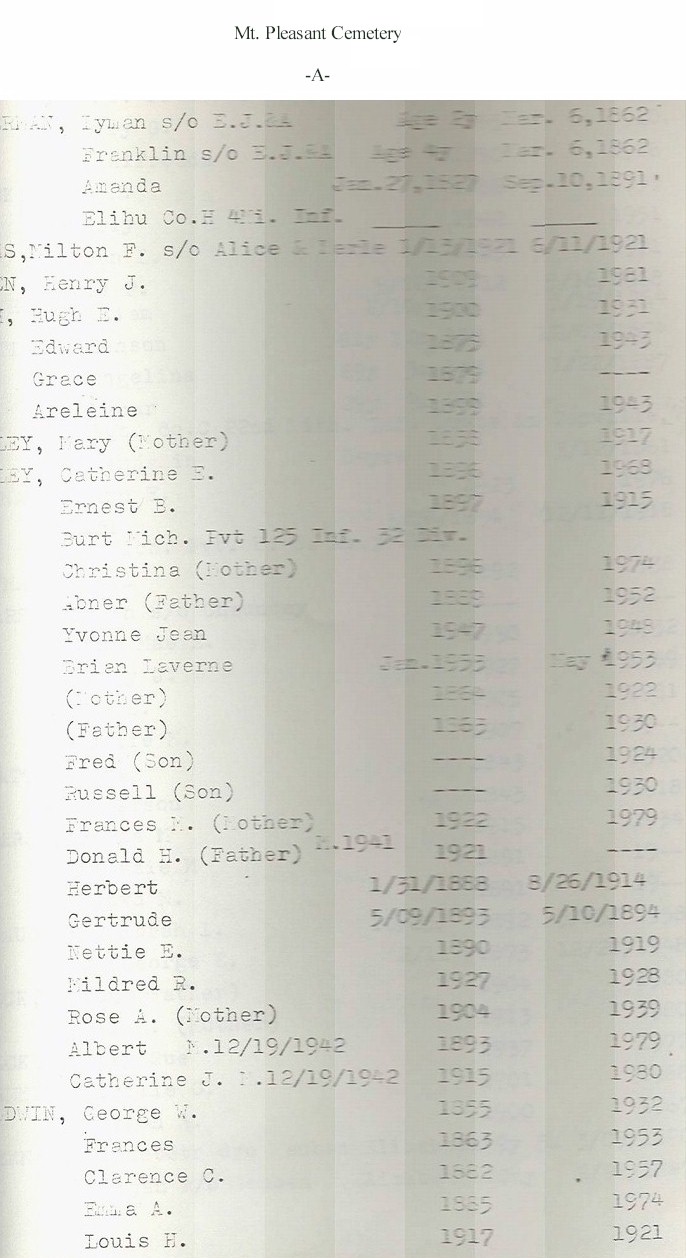
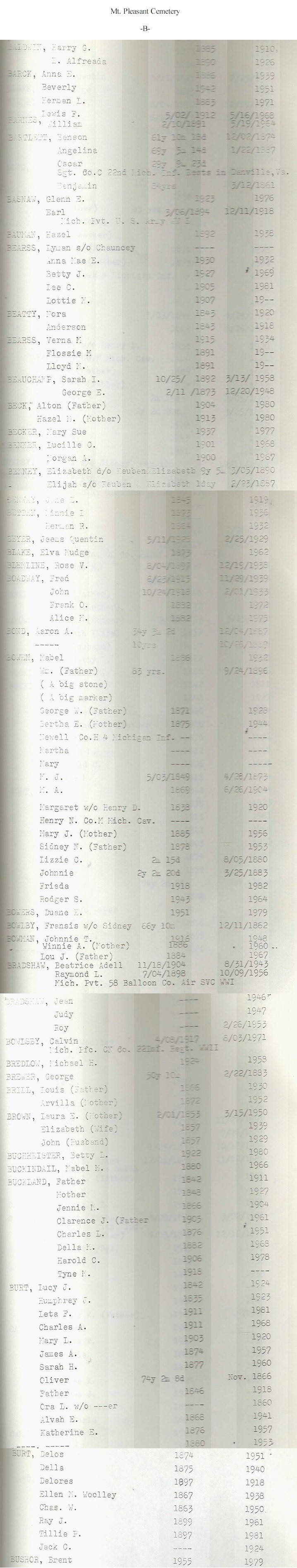
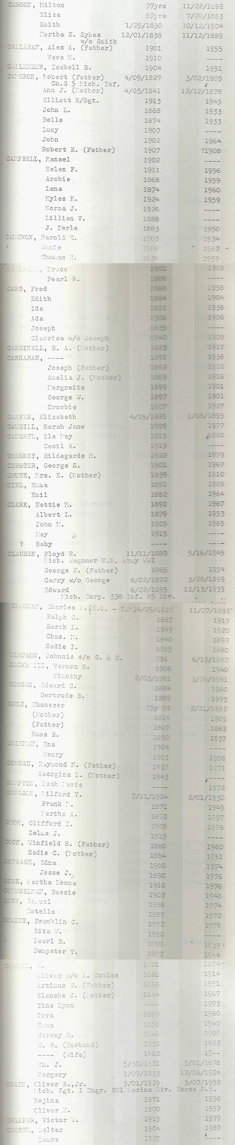
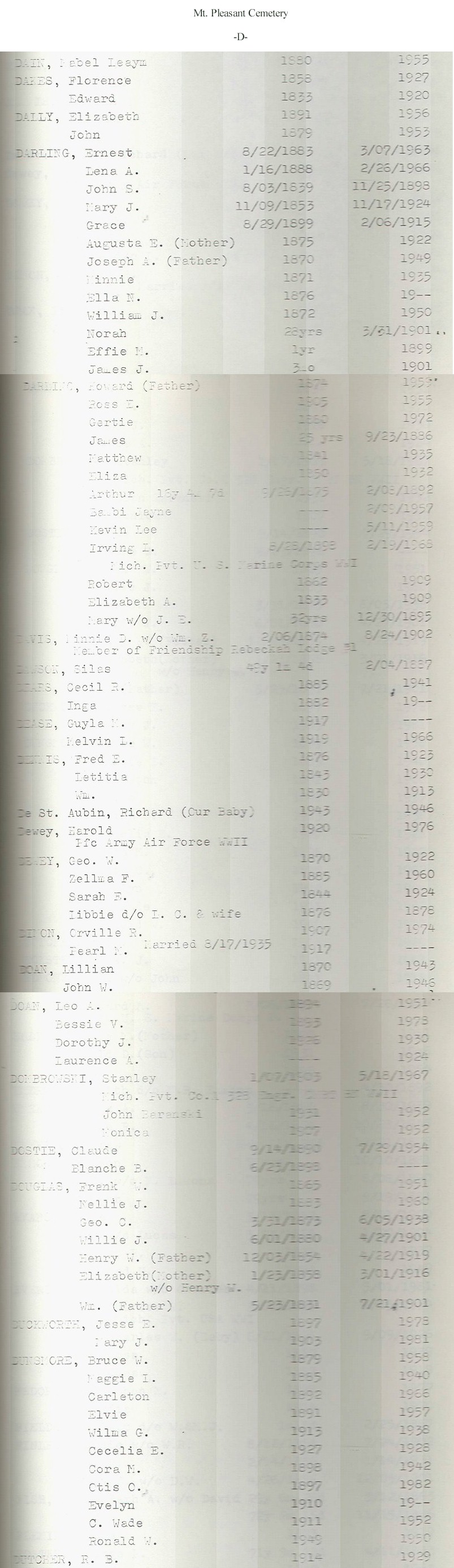
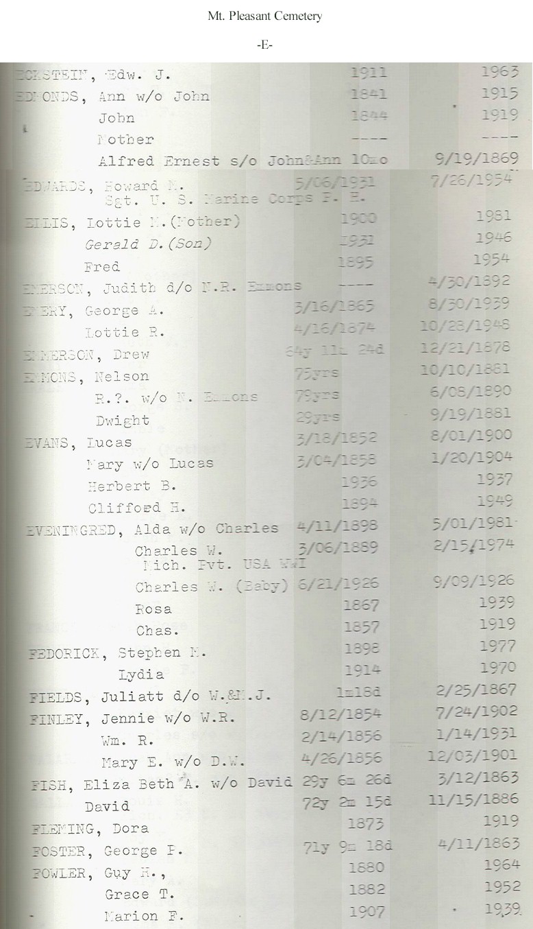
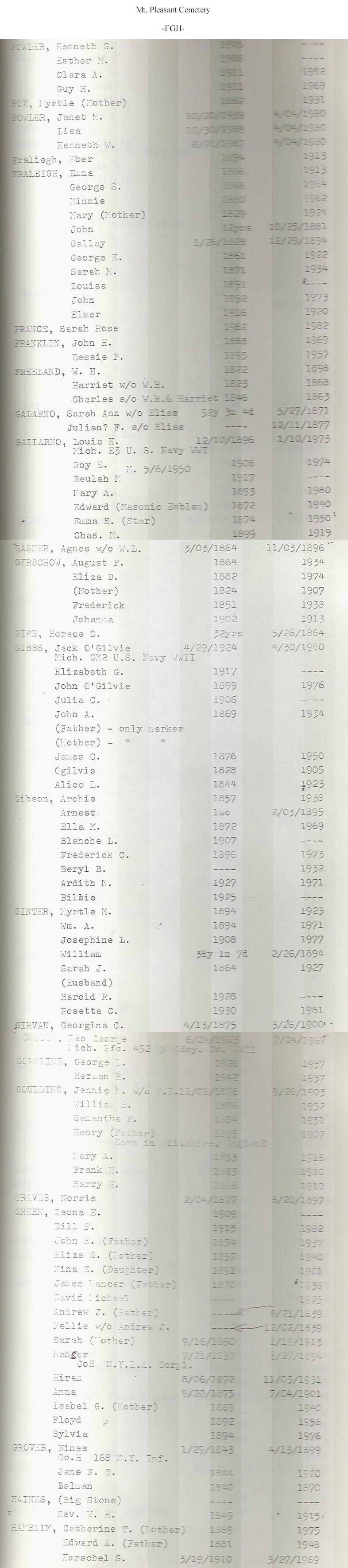
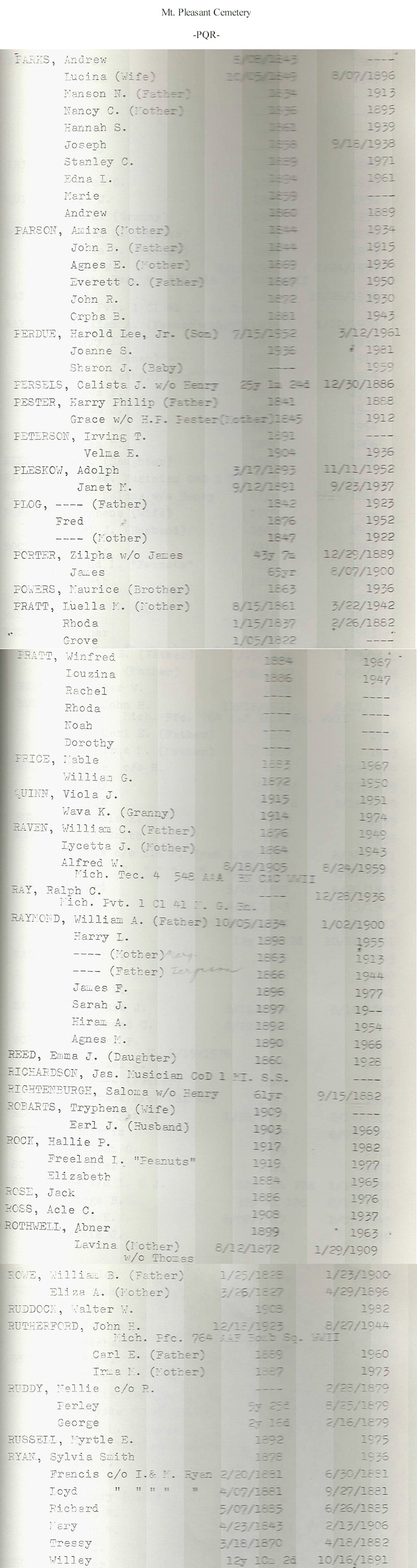
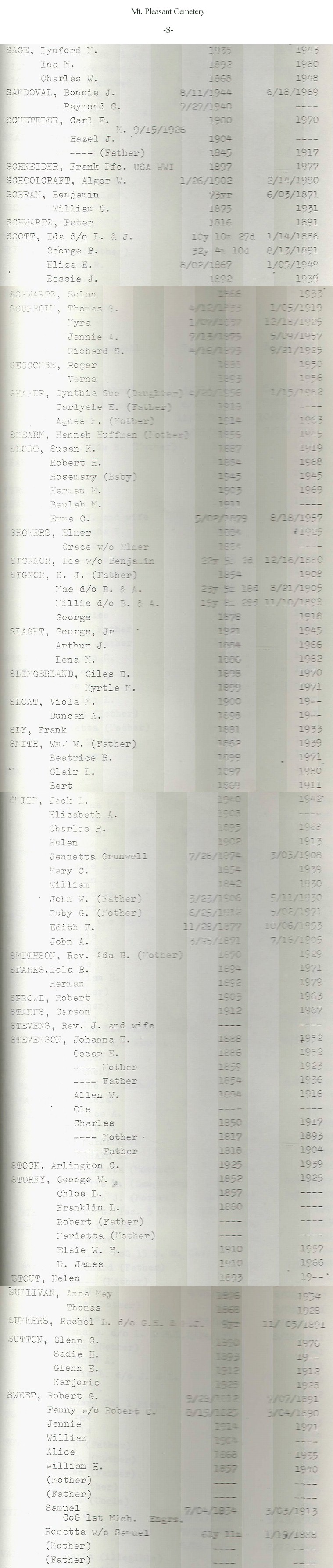
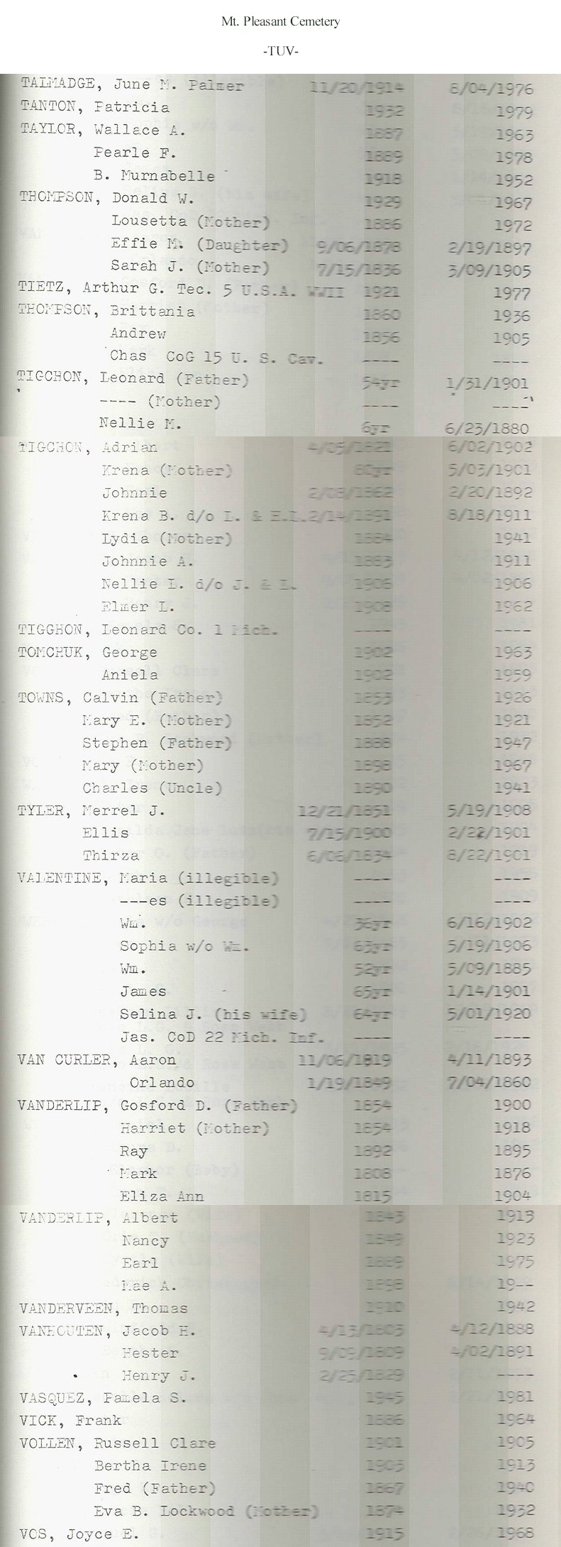
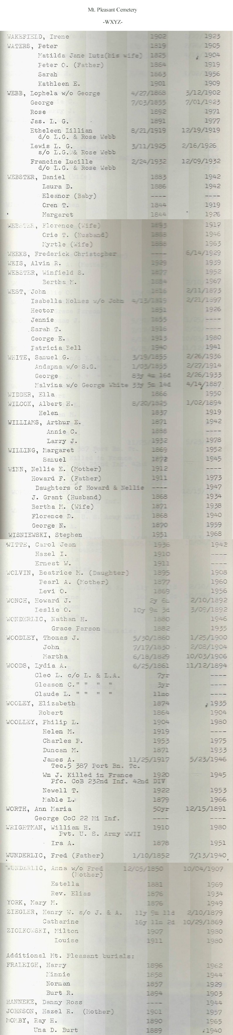
Mt.
Pleasant Cemetery:
Suzanne Frantz describes this as a "pretty little country cemetery [with an] adjacent church."
S 1/2, Sec. 14, Wales Twp. On Emerson Rd. near the intersection with Lambs Rd.
A
| B |
C
| D |
E
| FGH | IJKLMNO
| PQR |
S
| TUV |
WXYZ
& Miscellaneous |
Find-A-Grave
Mt. Sinai Cemetery:
This private Jewish cemetery is maintained, but it's uncertain whether it is in current use.
City-owned
Lakeside Cemetery is across Holland St. to the
north. In the city of Port Huron, on Holland St. at Walnut St.
Murphy's Cemetery (See
St. Rose Cemetery)
Oaklawn
(Oakland) Cemetery:
Debbie Smith Russell says that Oaklawn is "a very well kept cemetery with many large trees. It is also still active." She also notes that many of the Smith family involved with the Chris-Craft company in Algonac are buried there. Visited in June 1999.
In Clay Twp. just outside of the city of Algonac, on Smith St. at Cemetery St.
Database
|
Find-A-Grave
This small cemetery is not in current use, but is well-kept, according to Debbie Smith Russell and Suzanne Frantz. There are very few stones, only about 25 to 30. Visited in July 1999.
SW 1/4, Sec. 19, St. Clair Twp., on the north side of Yankee Rd. just east of Range Rd., before the railroad tracks.
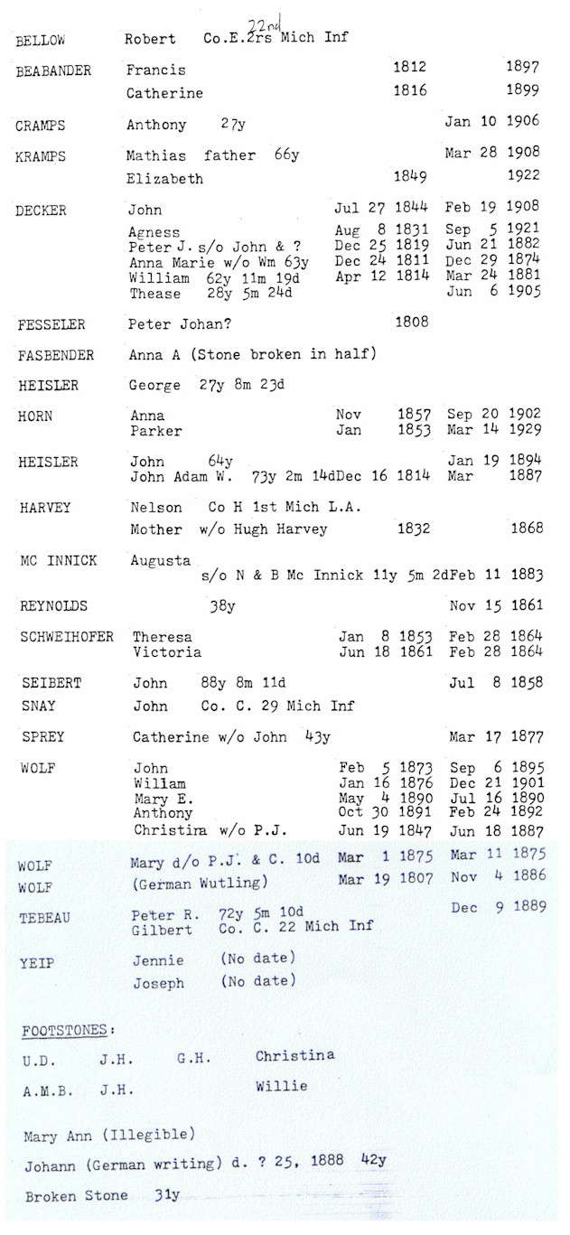
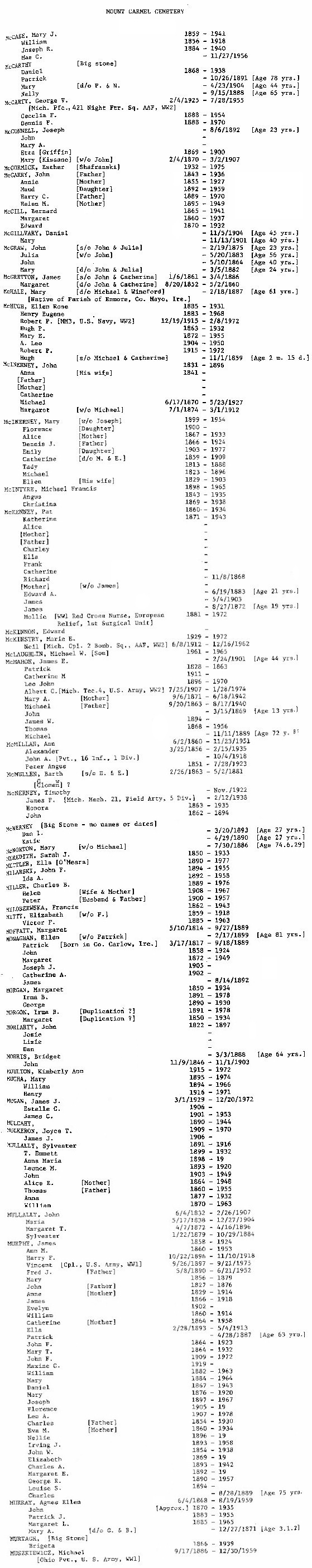
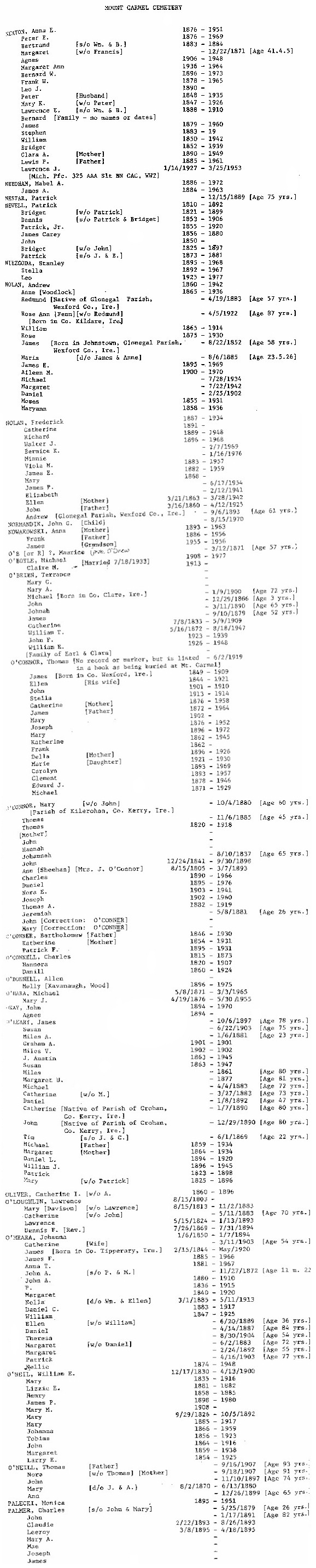
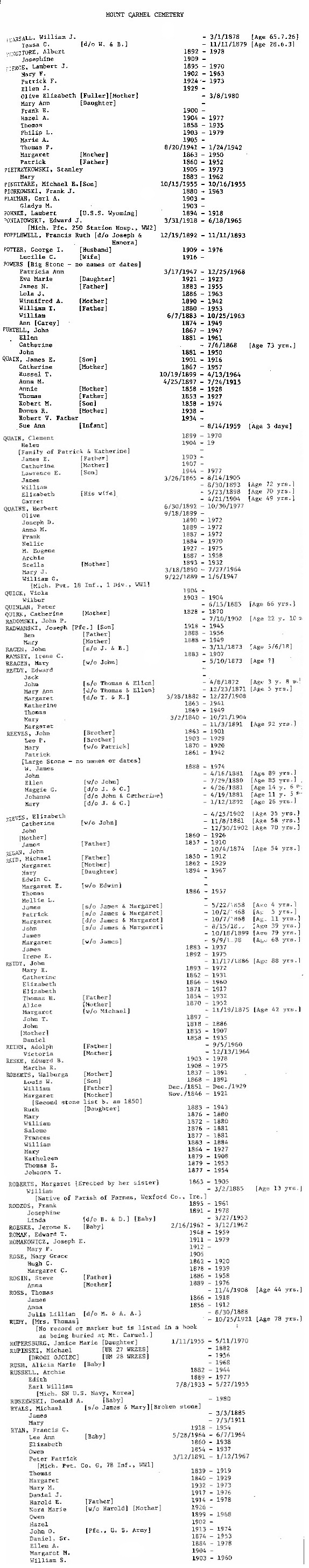
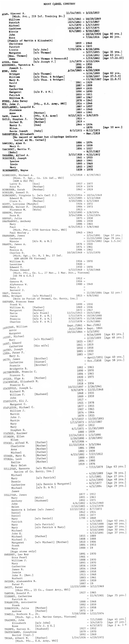
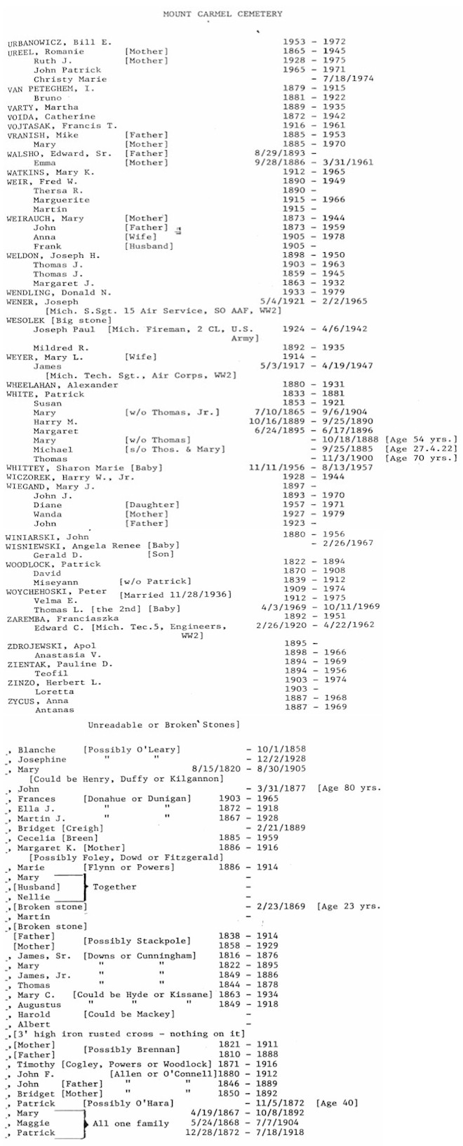
Our
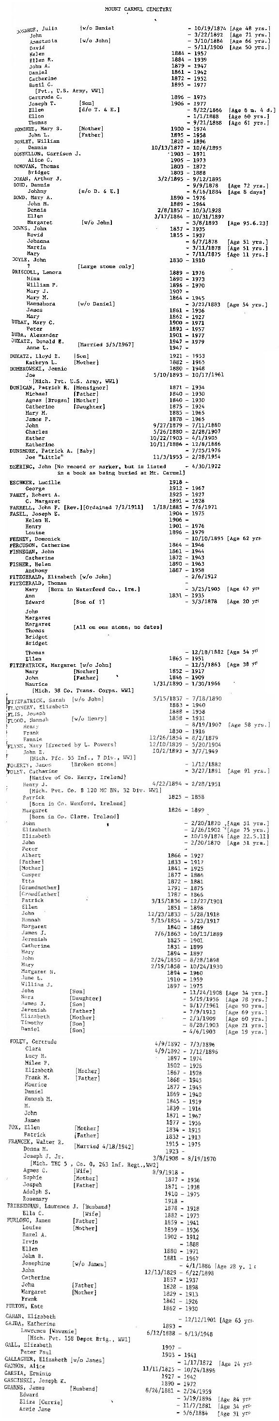
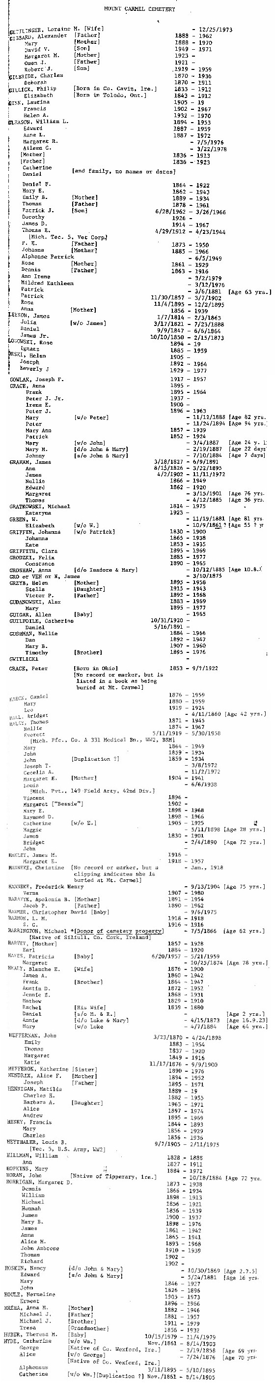
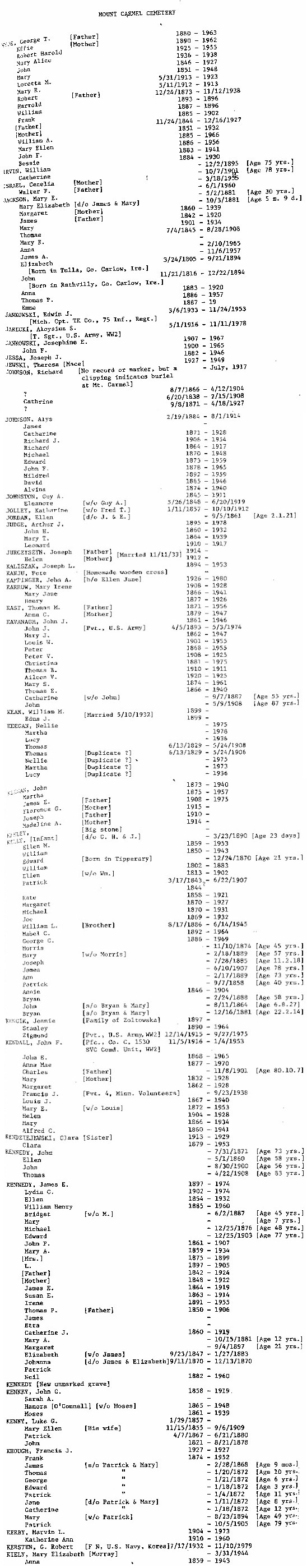
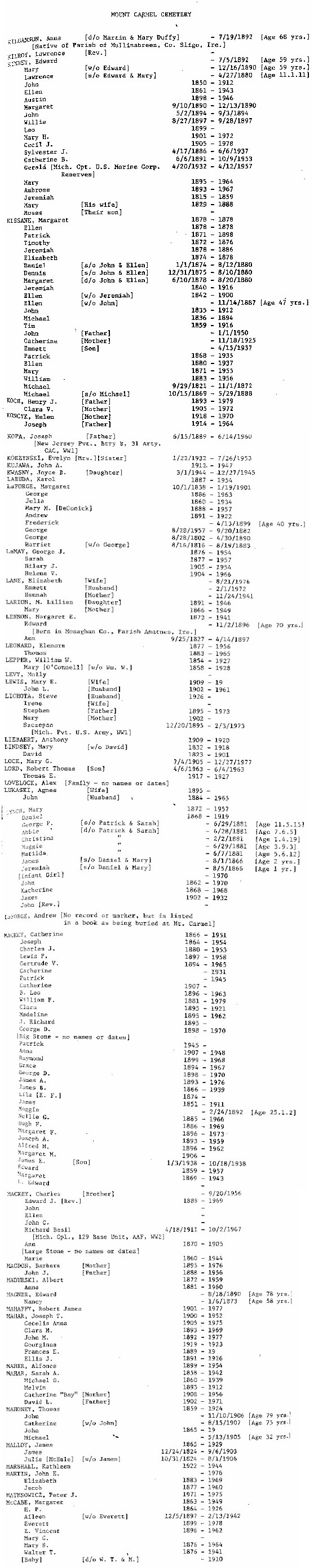
Lady of Mt. Carmel Cemetery
(aka
Kenockee Cemetery):
Melissa Lashbrook visited this cemetery in June 1999 and described it as "a beautiful country cemetery. The lawns and property are well manicured and cared for. What was the most impressive was the tombstones, which were huge, old, ornate monuments. It was nice to visit a cemetery that the names were at eye level."
Sue Gleason's mother-in-law is 90 years old and knows many stories of the residents of the surrounding area. Sue has been told that many of the cemetery records were destroyed in a fire in the mid 1960's.
She may be developing additional resources for the cemetery in the future ... stay tuned!
The historic Kenockee School is near the cemetery location.
SW 1/4, Sec. 32, Kenockee Twp. On Bricker Rd. (32 Bricker Rd.) south of Lapeer Rd. (old
M-21)
A-B |
B-C |
C-D |
D-G |
G-H |
H-K |
K-M |
M |
N-P |
P-R |
R-T |
U-Z & Miscellaneous
|
Find-A-Grave
Pettys
Cemetery
(aka
Streeter Cemetery):
Listed on the map printed in the Times Herald, 20 Aug 1995, from information provided by the St. Clair County Family History Group.
East side of M-25 in northern Burtchville Twp.
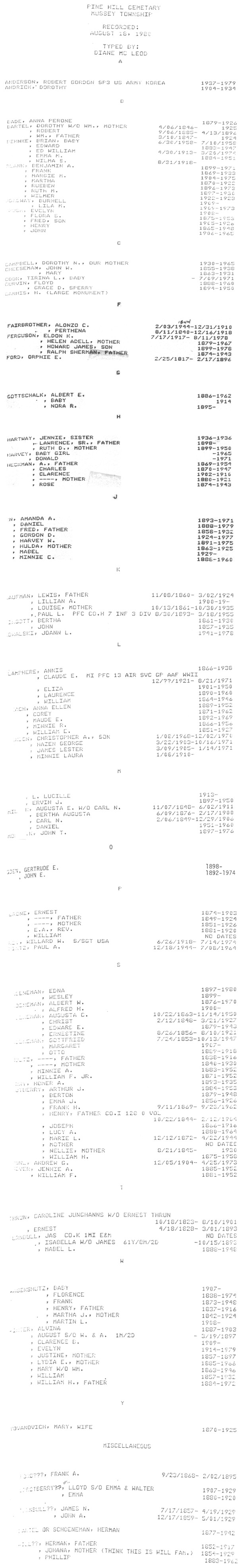
Pine Hill Cemetery:
This cemetery is easy to miss as you drive by. It's up a small hillside, and protected by three large pine trees near the road.
The cemetery is well-maintained and in current use. Graves date from the 1890s. Visited in July 1999.
E 1/2, Sec. 11, Mussey Twp. On east side of Hackman Rd. between Sullivan and Foley
Rds.
Find-A-Grave
Pine
Wood Cemetery
(defunct):
Suzanne Frantz sends along the following excerpt from "The Story of Port Huron," by Helen
Endlich:
"In 1850 Pine Wood Cemetery was established, going from Suffern St. (now Glenwood) north to the alley above Lincoln Ave. and from Fort Gratiot Reservation on the east to near 10th Street on the west. Pine Wood was Port Huron's cemetery until Lakeside was established about the end of the century. Many bodies were moved to the new cemetery, but in a number of cases the wooden boxes in which they had been buried had disintegrated. So whenever the basement for a new house was dug, bones would be found."
Relocations from
Pinewood to Lakeside
In the city of Port Huron; it was in the area of the intersection of Glenwood Ave. and Kearney St., north of the Black River and parallel
to Huron Ave.
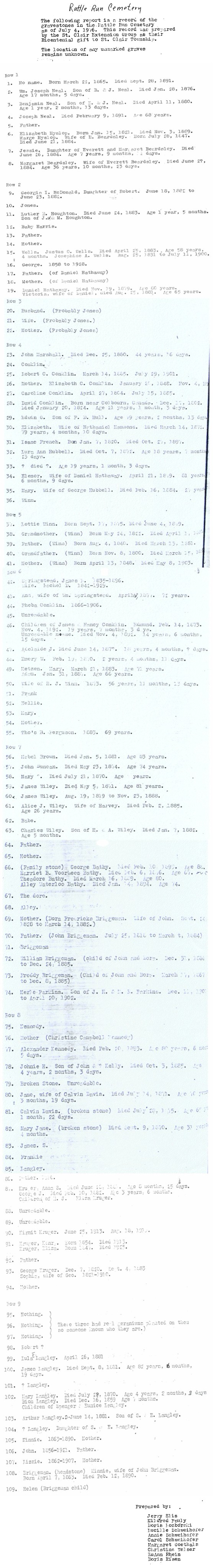
Rattle Run Cemetery (aka
State Road Cemetery; aka
St. Mary's ~ Rattle Run):
A small country cemetery with old stones, says Suzanne Frantz. Someone cuts the grass, but Sue isn't sure whether it's used for new burials. Visited in June 1999.
Visited in June 2007 by Kathleen Rodegeb. It's much the same now as when
Suzanne visited there in 1999. Some tombstone photographs have been added to
the tombstones page.
SE 1/4, Sec. 18, St. Clair Twp. Just SE of Gratiot Rd. on Rattle Run Rd., on the Rattle Run (creek).
Riverlawn
Cemetery:
Beautiful and extremely well-kept cemetery, and in current use, according to Debbie Smith Russell. The stones are all flat to the ground.
Possibly also known as
Mack's Cemetery?
In the city of Marysville, south of Cuttle Rd. on the west side of N. River Rd., across from St. Clair River.
Find-A-Grave
Robertson's
Land
(aka
Henry Robertson's [Robinson's?] Cemetery):
Listed on the map printed in the Times Herald, 20 Aug 1995, from information provided by the St. Clair County Family History Group.
In the city of Port Huron, near the intersection of Griswold and Military Sts.
Rosehill
Cemetery
(aka Rose Hill Cemetery):
Very well-maintained and in current use, according to Suzanne Frantz. Visited in June 1999.
Suzanne tells us there are some "very old graves here."
NW 1/4, Sec. 18, East China Twp. On Puttygut Rd. west of River Rd. (M-29)
SE 1/4, Sec. 17, Clyde Twp. Just SE of Ruby on Milwaukee Creek Rd., near intersection with Ford Rd.
Sacred
Heart Cemetery:
Ira Township
Debbie Smith Russell tells us this cemetery is "very well kept and is active." Visited in June 1999.
St. Mary's Cemetery is across Church Rd. to the
east.
SE 1/4, Sec. 8, Ira Twp. On west side of Church Rd. just north of Dixie Hwy. (M-29) and Shortcut Rd.
Sacred
Heart Cemetery: Yale
Very neat Catholic cemetery with chapel and grotto. In current use. Has a stone wall running the length of the cemetery on Yale Road. Visited in July 1999.
The public
Elmwood Cemetery is adjacent, just to the
west.
Sacred Heart Church,
310 North Main St.,
Yale, MI 48097, (810) 387-2998
SW 1/4, Sec. 10, Brockway Twp. Just west of Yale on Yale Rd. near Jorden Rd.
Database |
Find-A-Grave
St. Catherine's
Cemetery:
St. Catherine's is exceptionally well kept and is active, according to Debbie Smith Russell. Visited in June 1999.
SW 1/4, Sec. 3, Clay Twp. Just NW of Algonac on Smith St./Stone Rd.
St. Edward's Cemetery
(See St. Lawrence Cemetery)
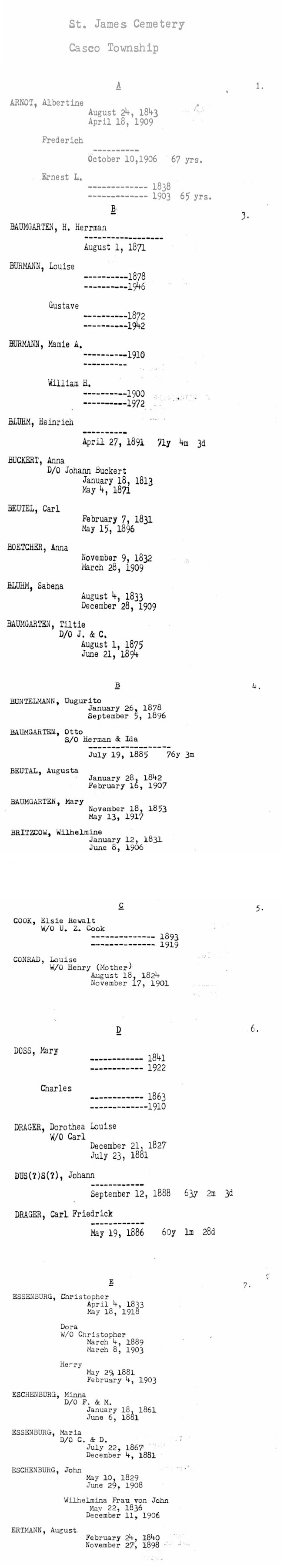
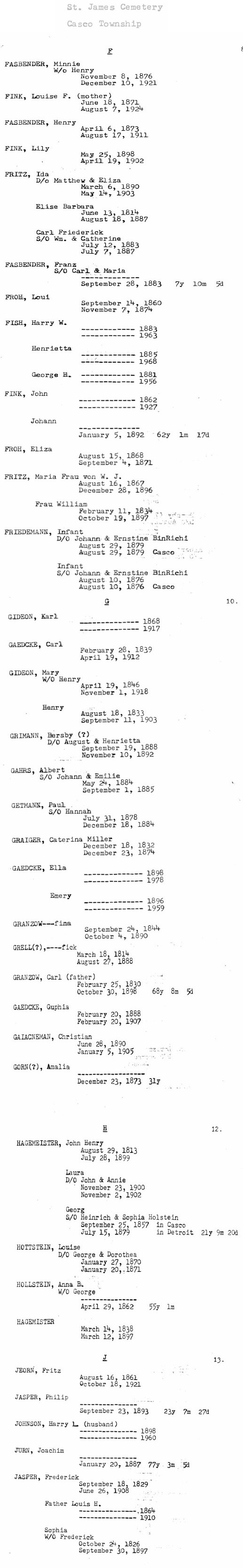
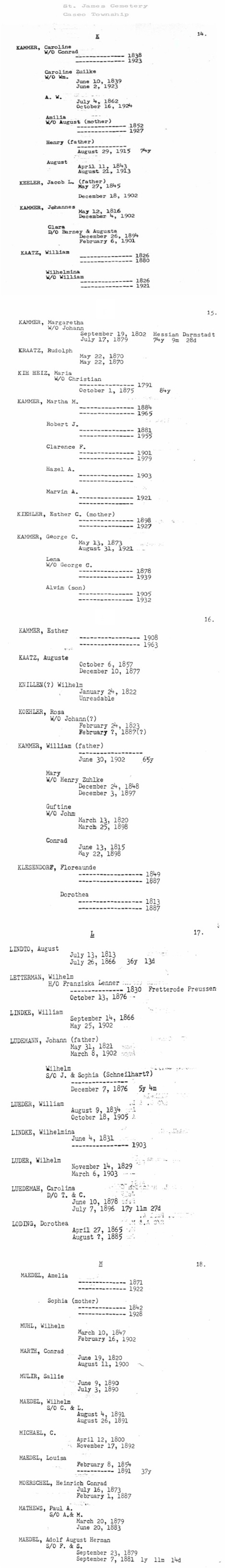
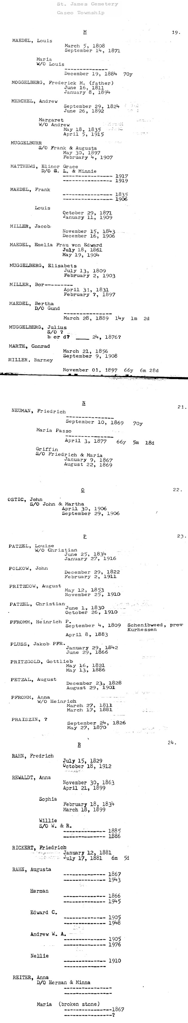
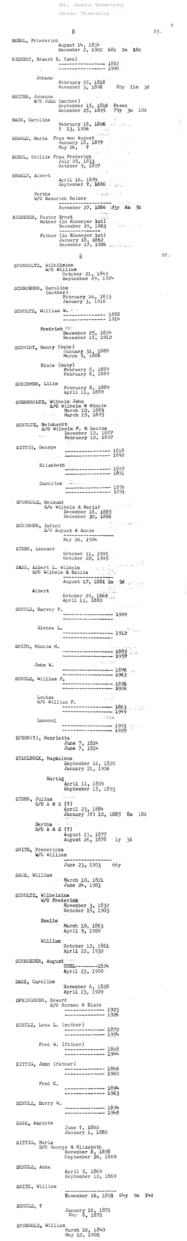
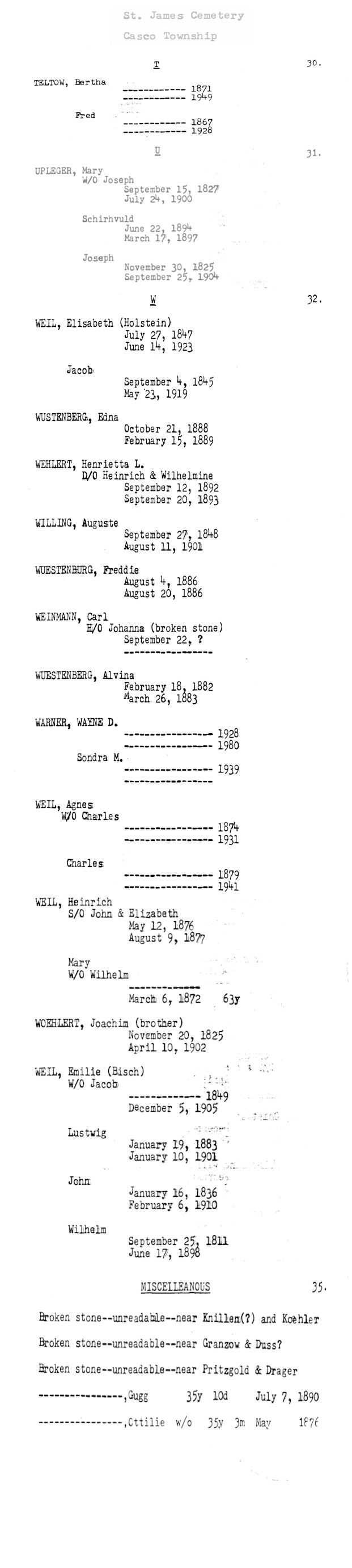
St. James Cemetery
(aka
Casco Cemetery):
St. James was established in 1858, according to a sign at the site, according to Kathy
Hewelt. Visited in July 1999.
SE 1/4, Sec. 21, Casco Twp. Behind a little church on the northwest corner of Meisner and Meldrum
Rds.
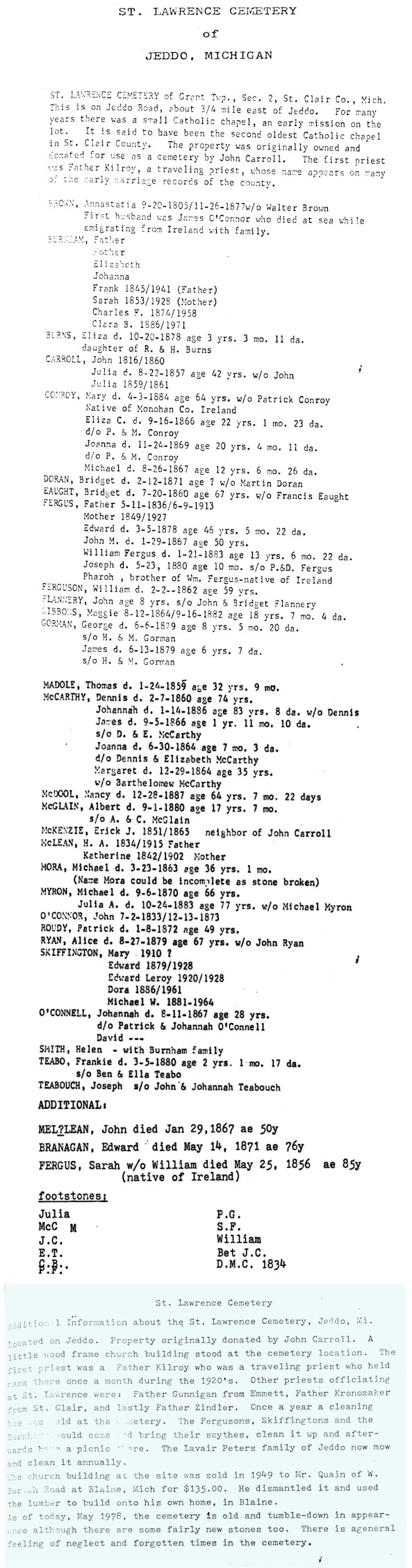
St. Lawrence Cemetery
(aka
St. Edward's Cemetery):
I couldn't find this one during a tour of the northern part of the county in July 1999.
SE 1/4, Sec. 3, Grant Twp. East of Jeddo on Jeddo Rd., between Wildcat and Vincent Rds. on Burtch Creek.
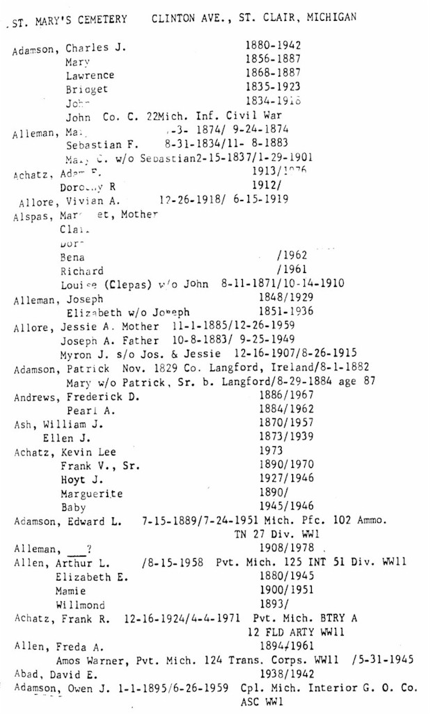
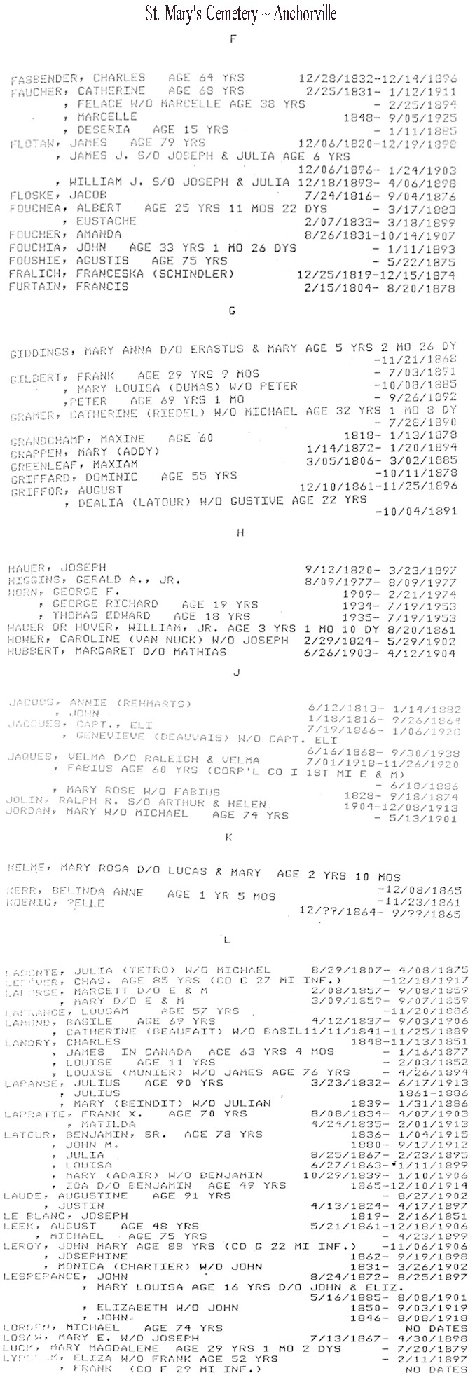
St. Mary's
Cemetery:
Private Catholic cemetery, in current use and well-maintained.
Identified by site visitor, Mike, as the Rattle Run Road St. Mary's Cemetery,
but note that the information on the transcripts shows it located on Clinton
Ave. (Clinton Ave. turns into Rattle Run Rd. as you head west out of town). There are records at the library for a St. Mary's Cemetery on
Rattle Run Road, identified in the transcripts as "Rattle Run
Cemetery".
E 1/2, Sec. 35, St. Clair Twp. Just west of St. Clair on Rattle Run Rd. Cemetery spans both the north and south sides of the road.
St. Mary's Cemetery
~ St. Clair Township (See also
Murphy's and
St. Rose Cemetery Cemeteries):
According to site visitor Sheila Gavin, this is
Murphy's Cemetery.
St. Mary's
Cemetery (St. Mary's ~ Sacred Heart)
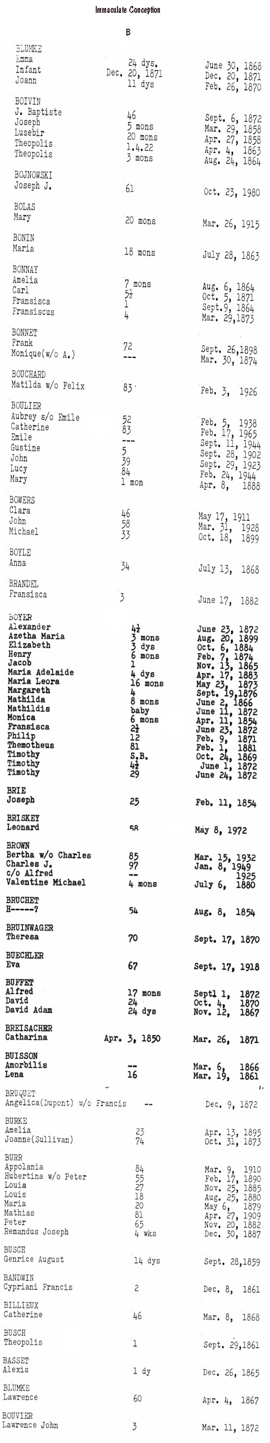
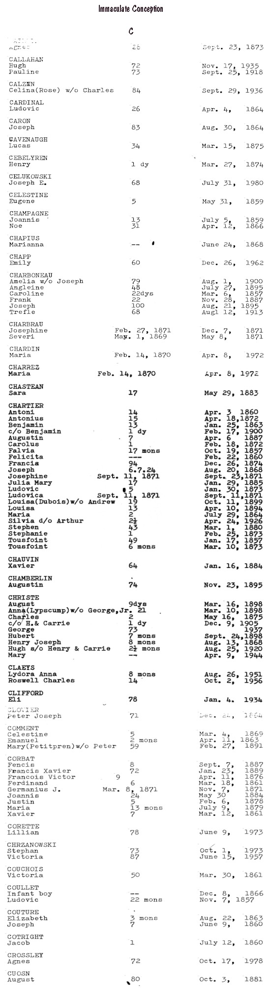
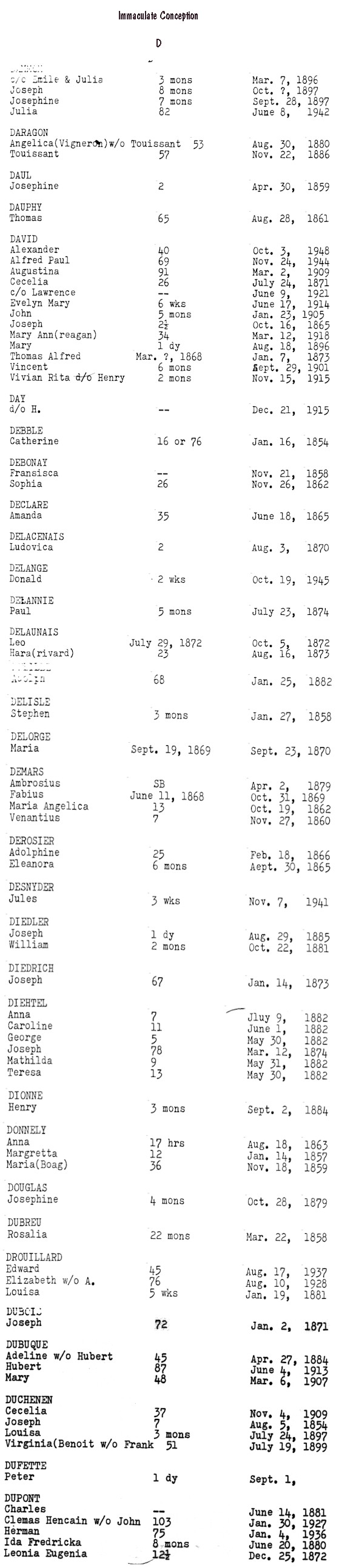
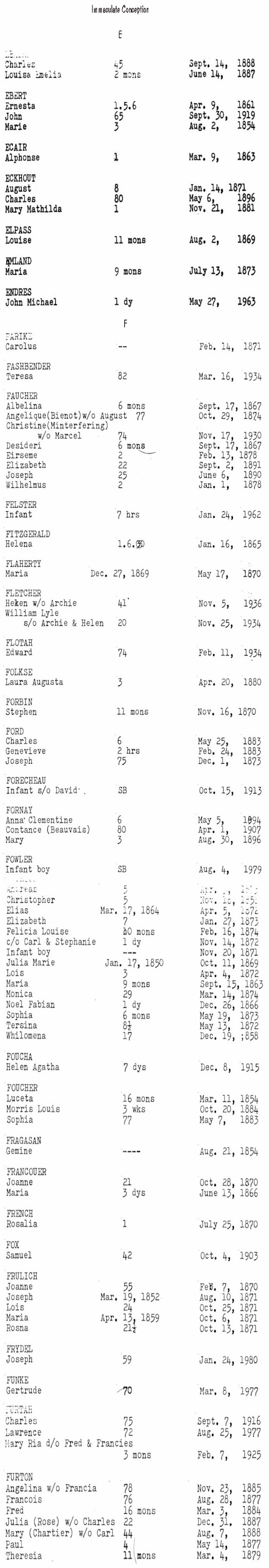
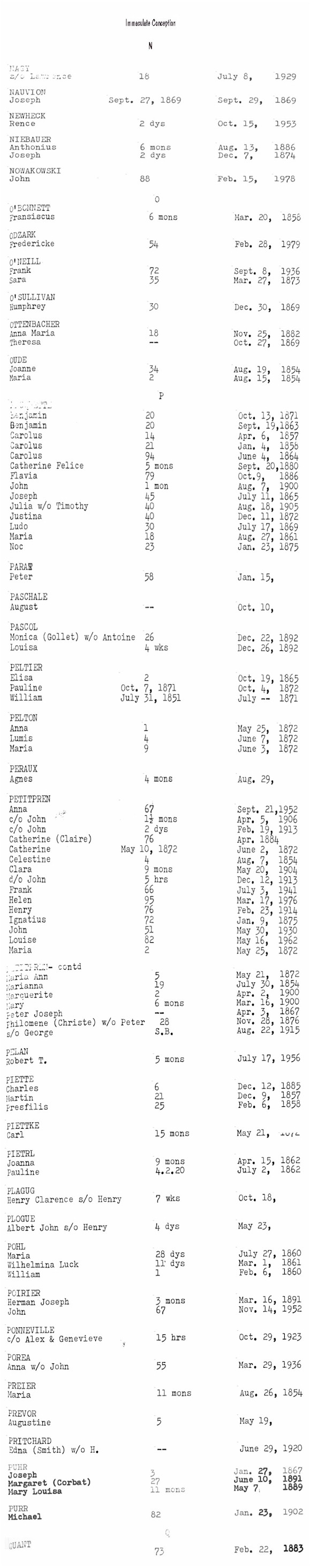
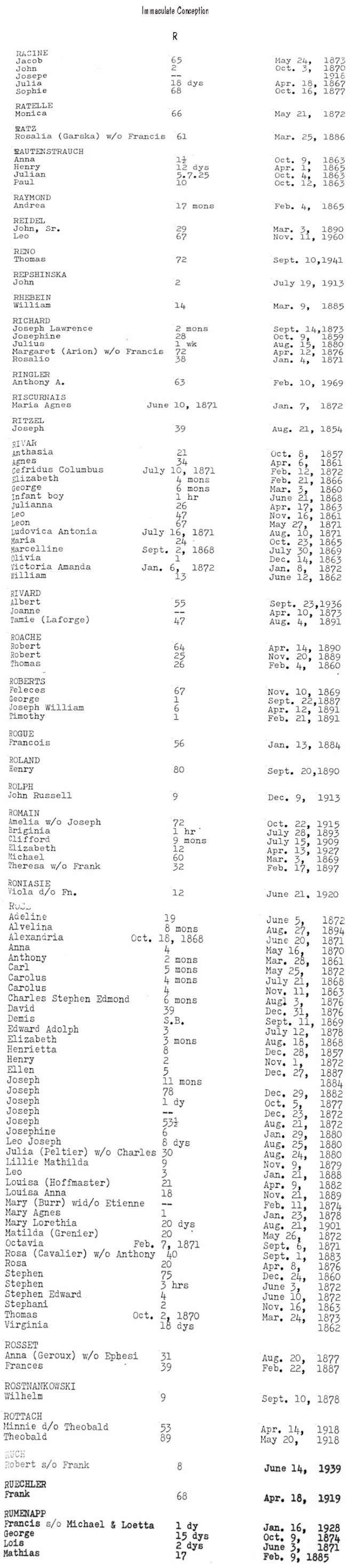
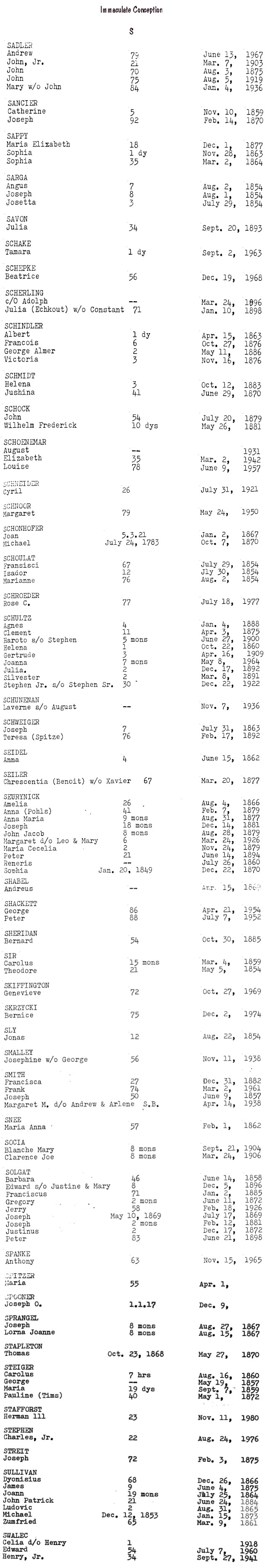
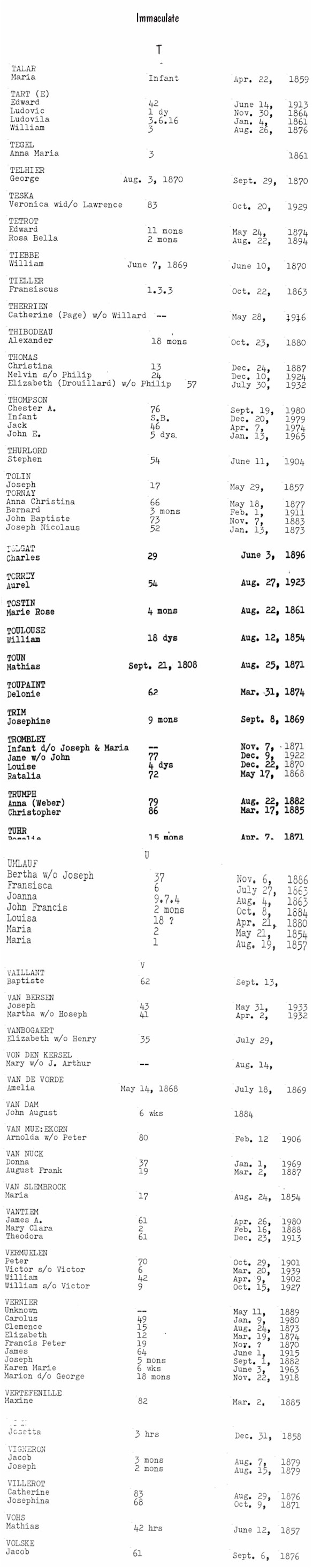
(aka Immaculate Conception Cemetery):
This St. Mary's is well kept, but Debbie Smith Russell isn't sure if it's active; "doesn't seem to be any recent burials." Visited in June 1999.
Sacred Heart Cemetery is across Church Rd. to the
west.
SW 1/4, Sec. 9, Ira Twp. On east side of Church Rd. just north of Dixie Hwy. (M-29) and Shortcut Rd.
A-B |
B |
C |
D |
E-F |
G-J |
K |
L |
M |
N-Q |
R |
S |
T-V |
W-Z & Miscellaneous
|
Others
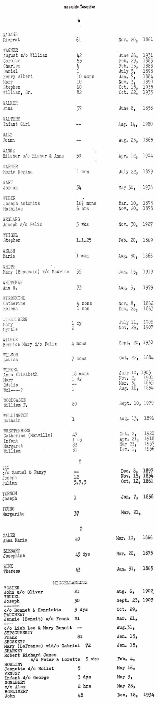
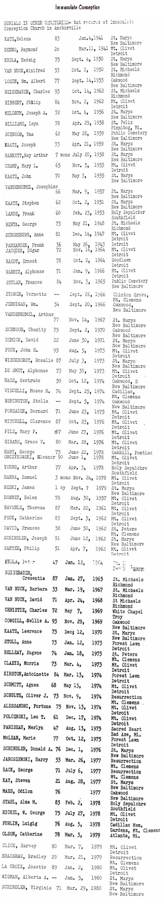
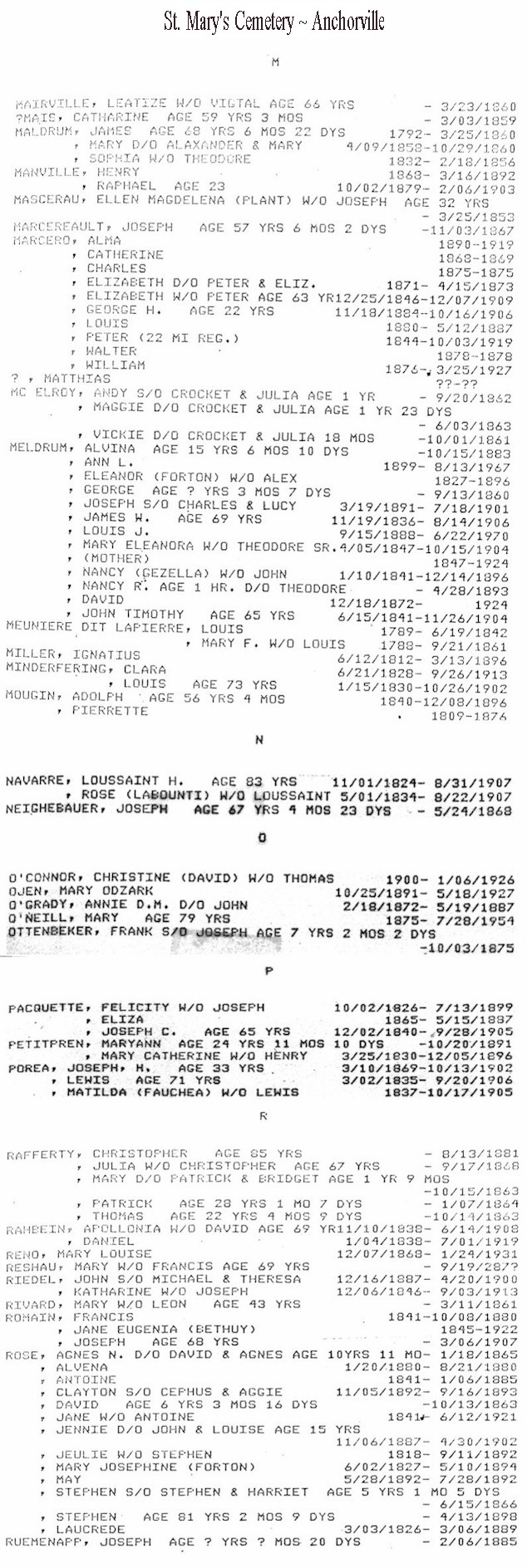
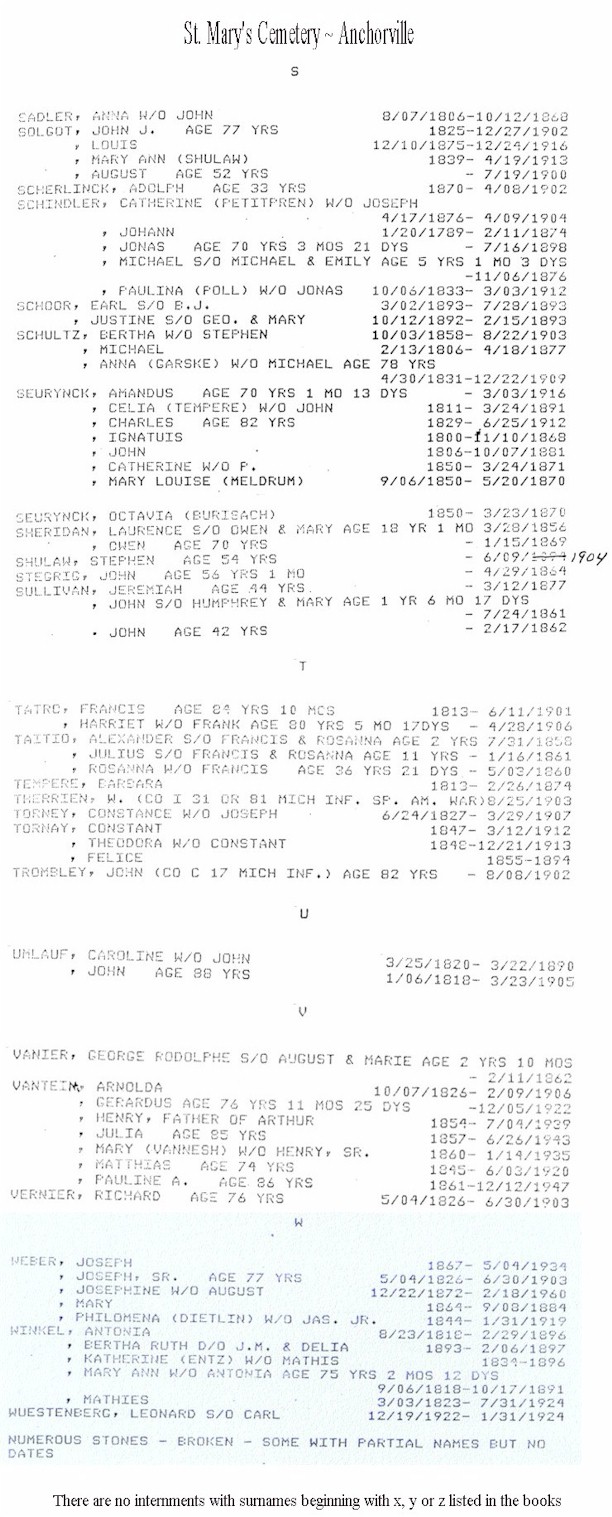
St. Mary's Cemetery ~
Anchorville:
From the USGS map this seems to
be on Church Rd. off Short Cut Rd. outside Anchorville, New Baltimore and Fair
Haven. Please email the County
Coordinator if you know the
address of this cemetery. Site visitor Lorraine reports that the cemetery
is on Church Rd., directly behind Immaculate Conception Church. The newer
cemetery is directly across the road from the old one. Site visitor Ed Holbrook
reports that the cemetery is about 1/2 mile north of the church on Church Rd.
East |
West
| jpg images: East |
West A-M |
West N-Z |
Miscellaneous
|
Find-A-Grave
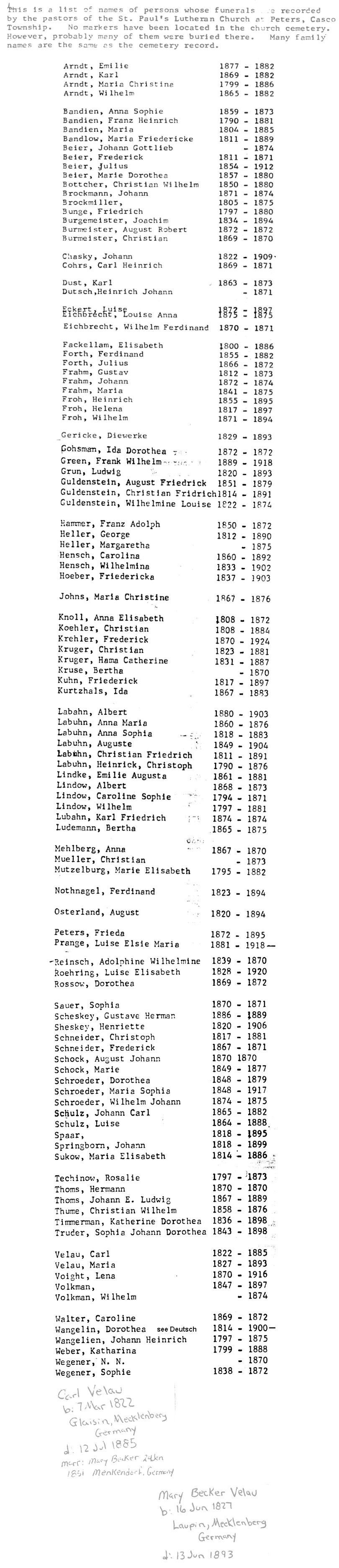
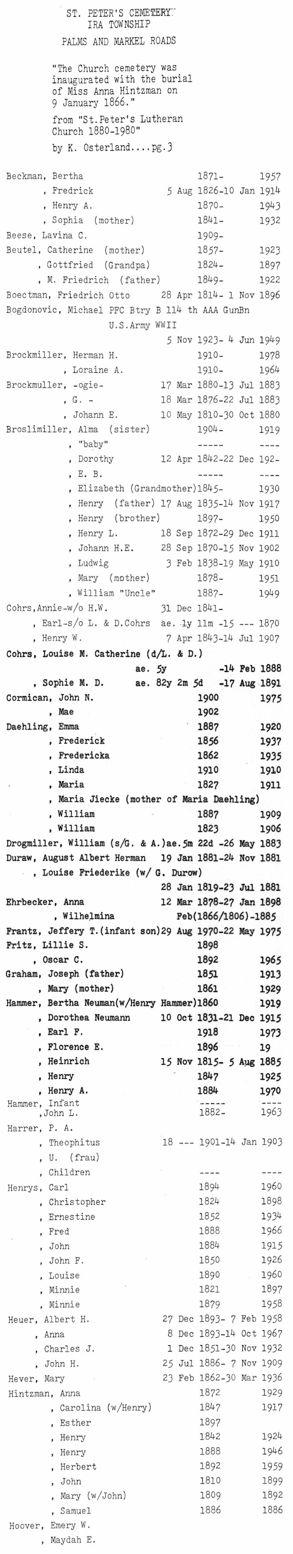
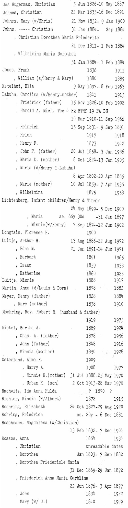
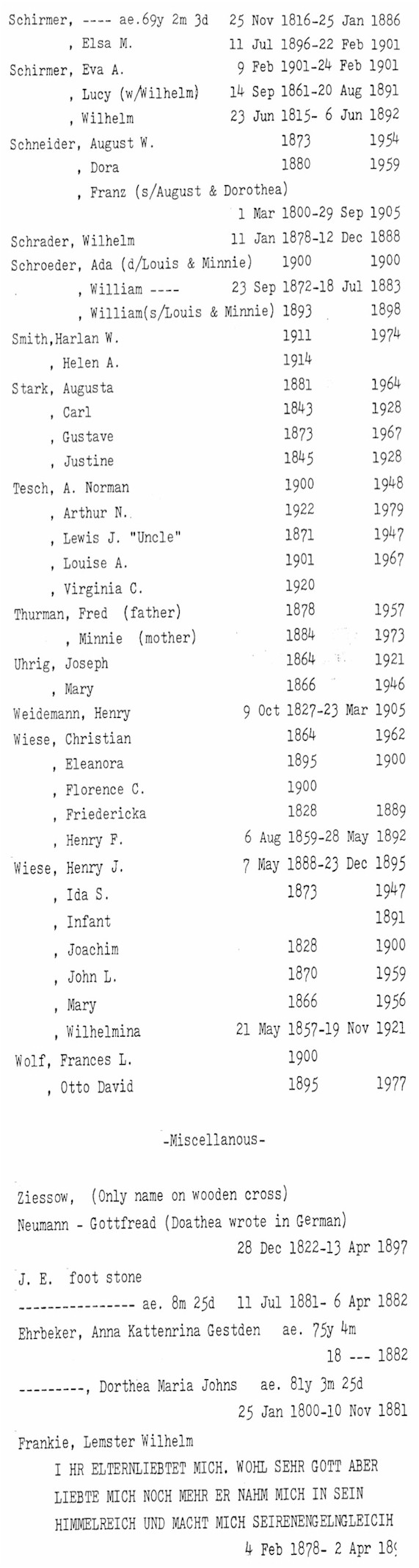
St. Peter's
Lutheran Cemetery:
Debbie Russell tells us that this cemetery is behind a small country church, is well kept and active. Burials date from the 1880's to present. Visited in September 1999.
NW 1/4, Sec. 12, Ira Twp. On NE corner of Palms Rd. at Markel Rd.
St.
Philip Neri Cemetery
(aka St. Phillip's Cemetery):
Private Catholic cemetery, in current use and well-maintained. Visited in July 1999.
St. Philip Neri Church,
9735 Dolan Road,
Columbus, MI 48063, (810) 727-3913
SW 1/4, Sec. 5, Columbus Twp. On SW corner of the intersection of Bauman and Dolan Rds., across from the Catholic parish of the same name.
St.
Rose Cemetery (aka
Irish Cemetery, Murphy's Cemetery,
St. Mary's Cemetery):
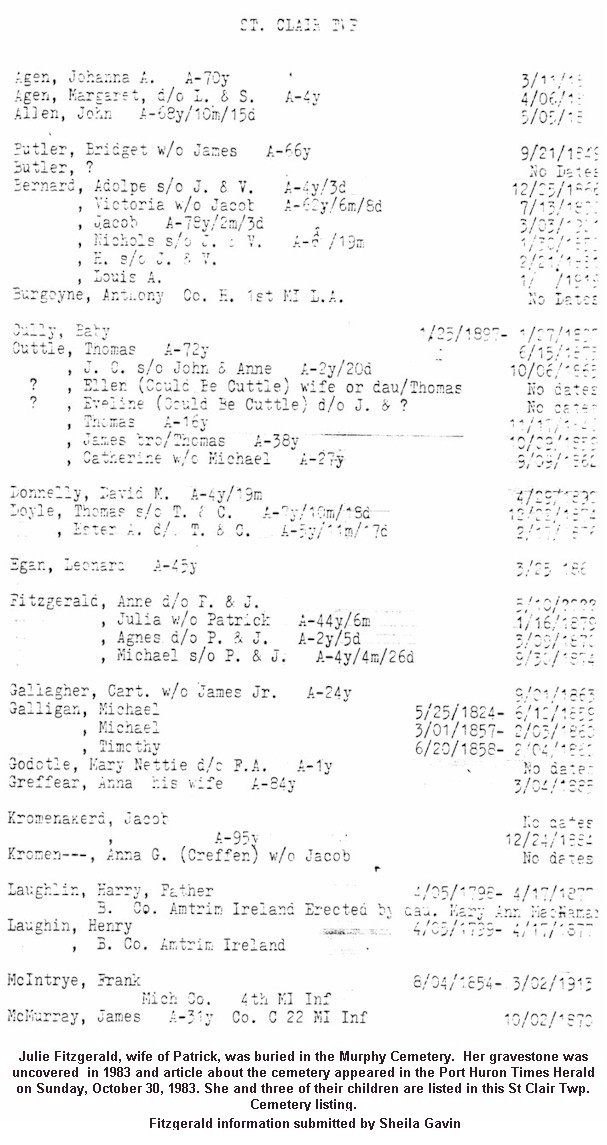
This one is completely overgrown with trees and brush. Most stones are illegible and broken. Debbie Smith Russell didn't find any that weren't broken or off their foundations. There are two Civil War grave markers. Most of the graves appear to be from the mid-1800s. "What a shame," Debbie notes. Visited in July 1999.
NW 1/4, Sec. 1, St. Clair Twp. On Murphy Dr. (the
second road west of the I-94/Gratiot Rd. interchange near Marysville)
Find-A-Grave
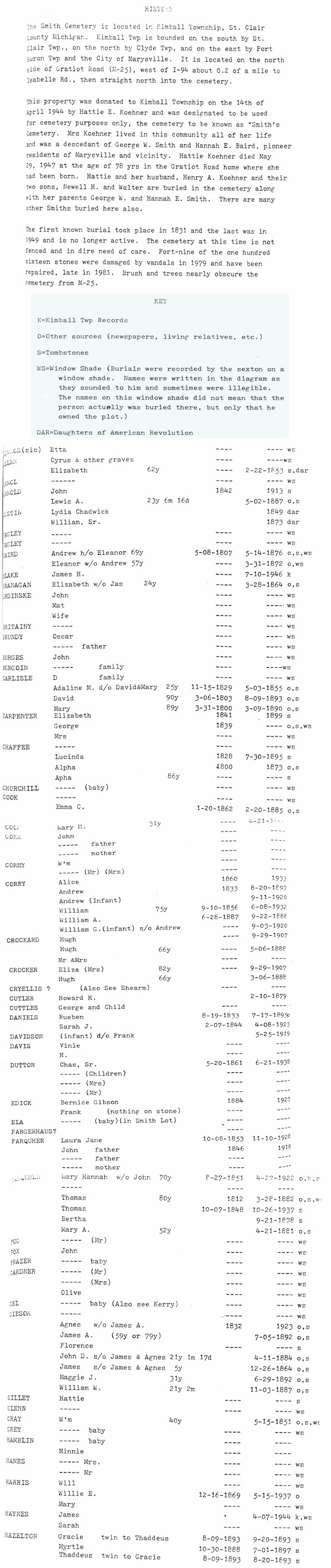
Smith Cemetery:
Debbie Smith Russell says that this Smith Cemetery is not active and is very run down.
SE 1/4, Sec. 36, Kimball Twp. Just west of I-94 interchange near Marysville, near the corner of Isabelle St. and Gratiot Ave.
A-H |
H-Z |
Database
|
Find-A-Grave | There are photographs of some of the tombstones at
Pictures of Port Huron.
Check back often until they are posted.
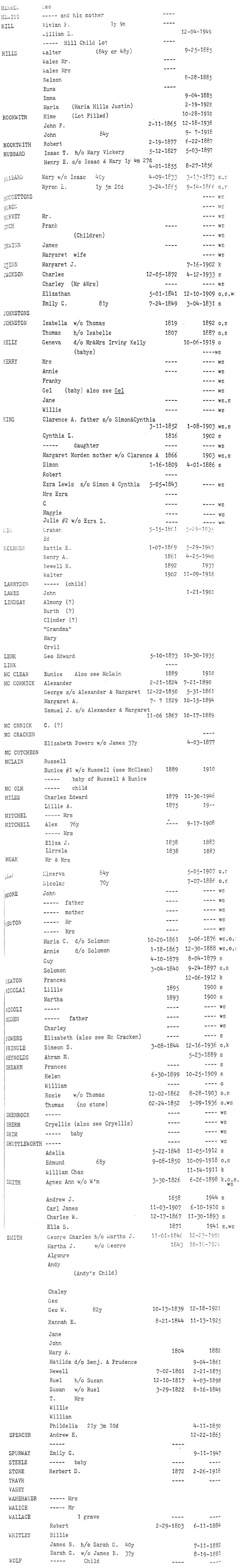
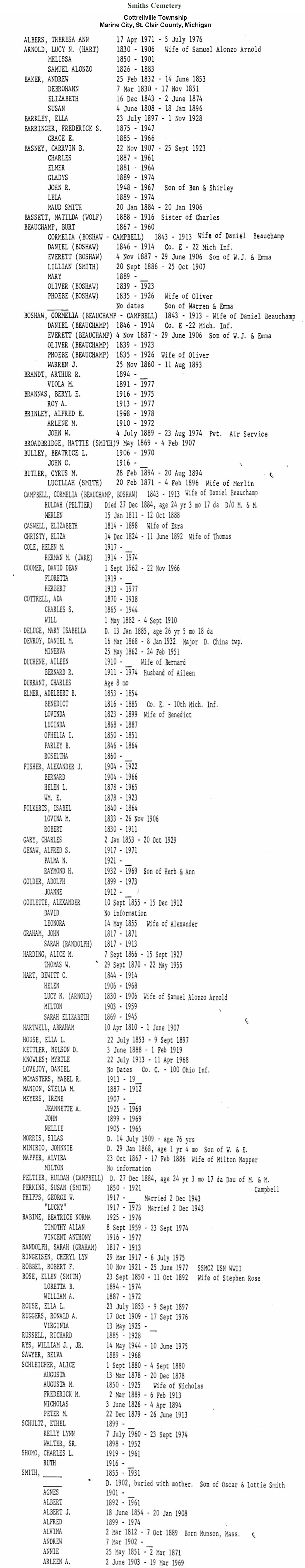
Smiths
Cemetery:
Active cemetery maintained by the Reuben Smith Burial Association.
Debbie Smith Russell has compiled the cemetery transcripts, which are available by clicking on the links
below. Debbie's parents maintain the cemetery on behalf of the Reuben Smith Burial Association. She has cross-referenced the list against Michigan Department of Health Death Index records and Cottrellville Township records, where available.
SW 1/4, Sec. 15, Cottrellville Twp. West of Marsh Rd. on Shortcut Rd.
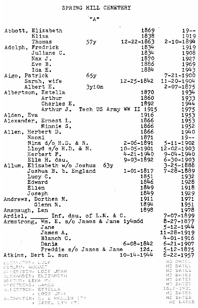
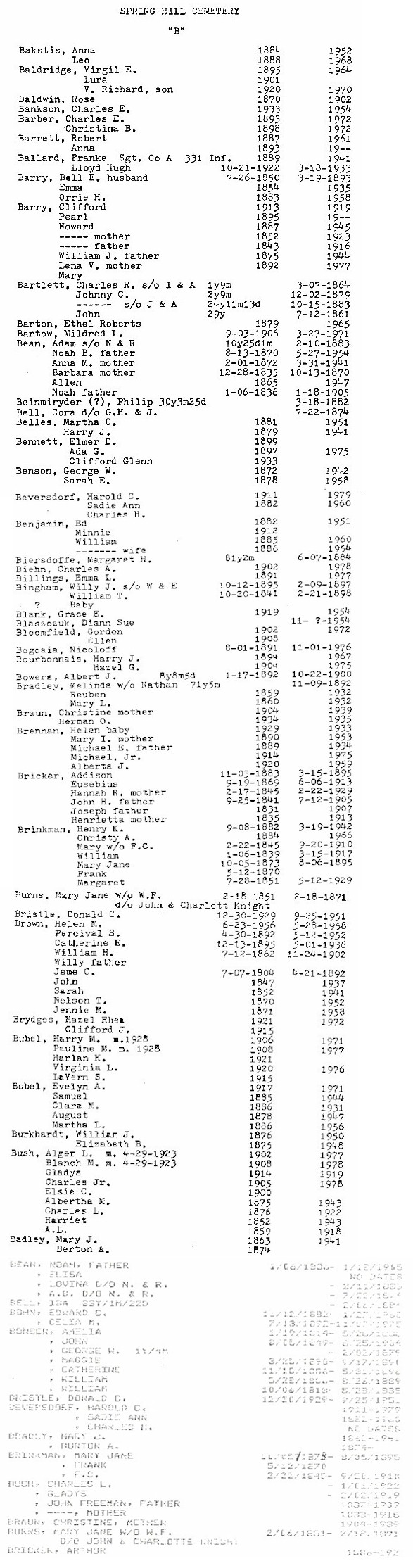
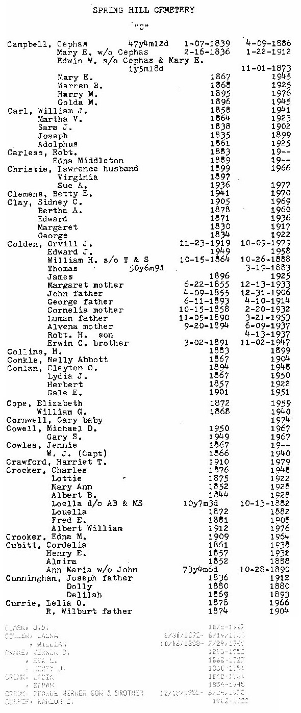
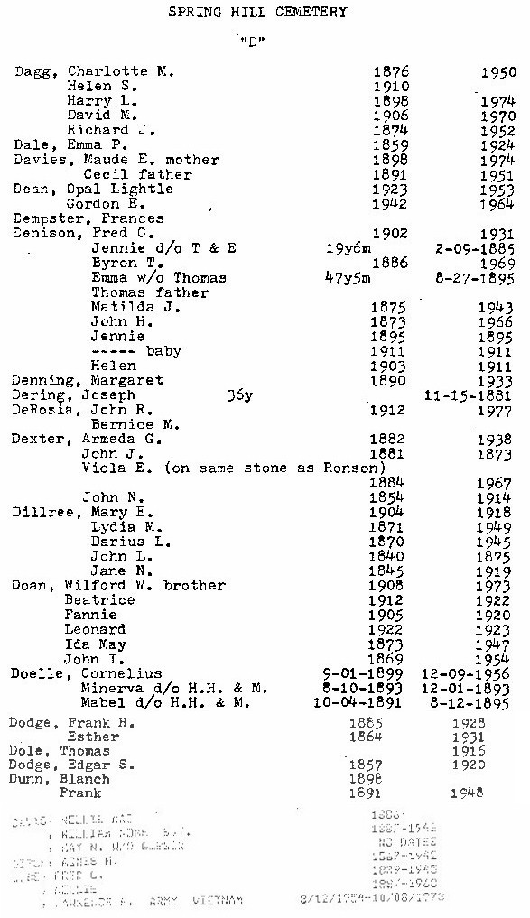
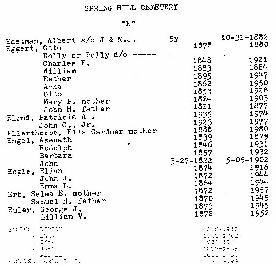
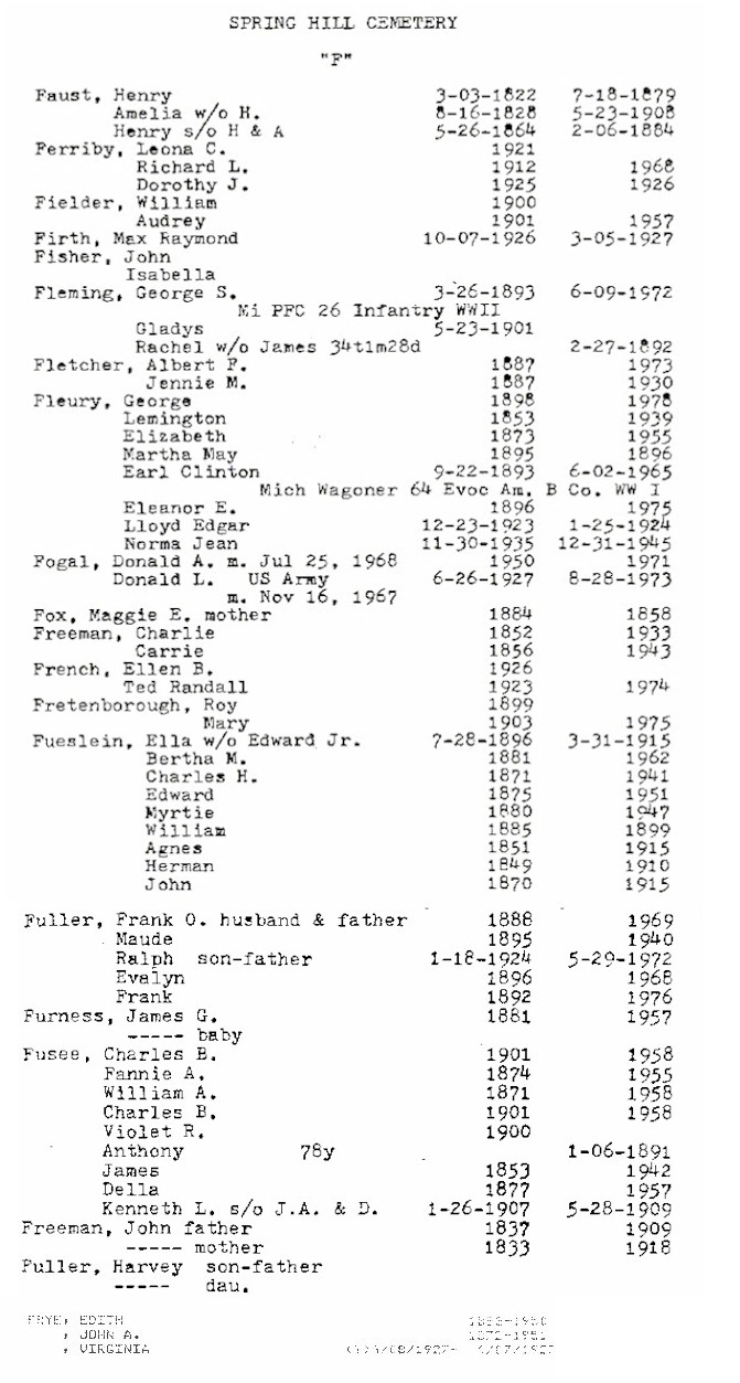
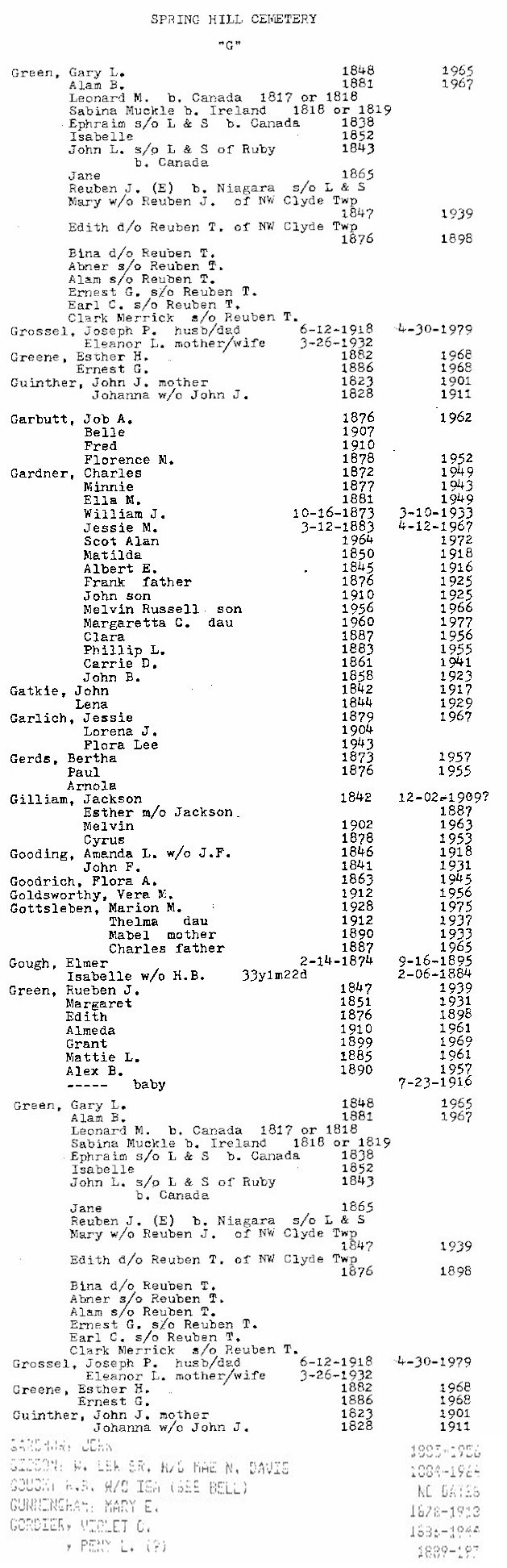
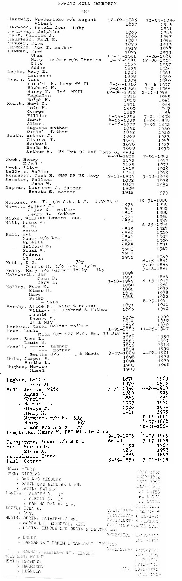
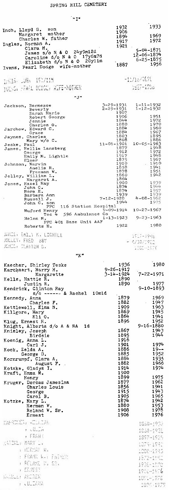
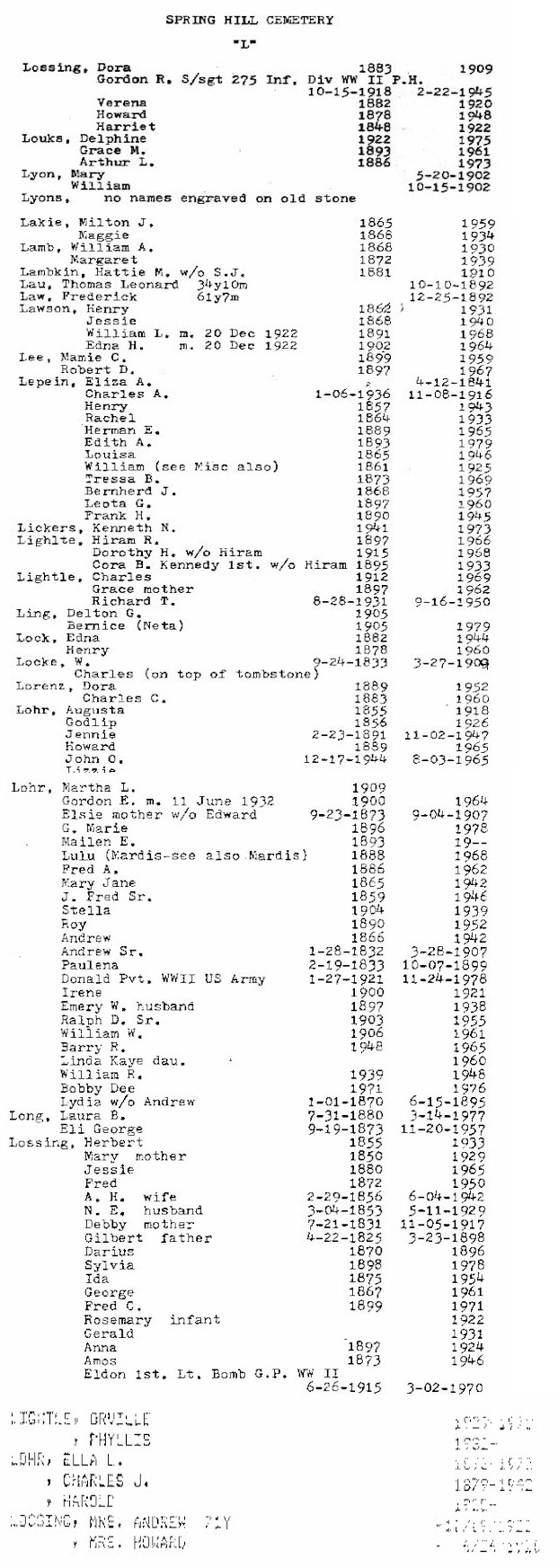
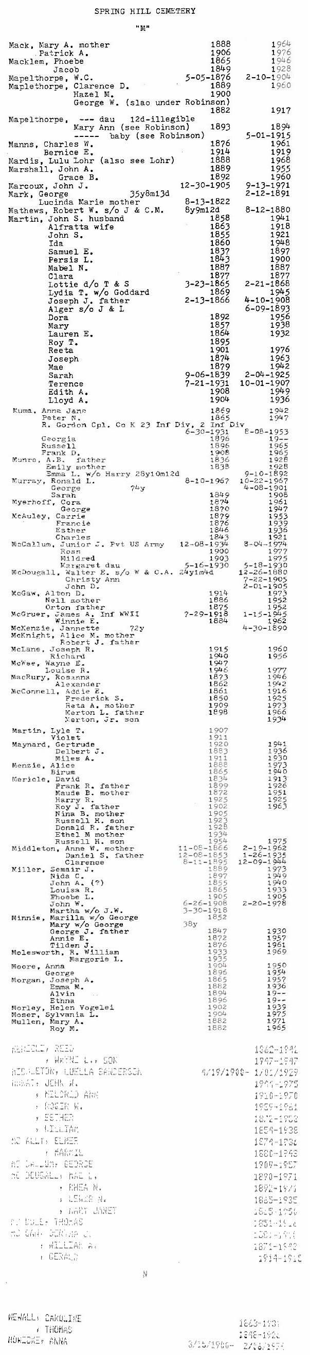
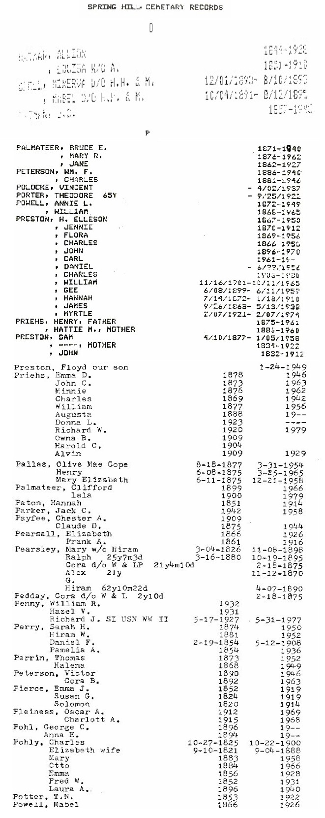
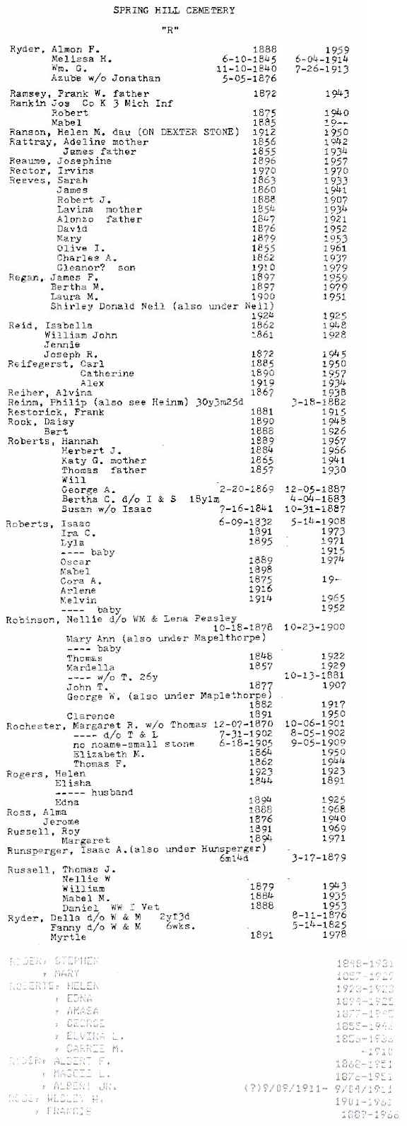
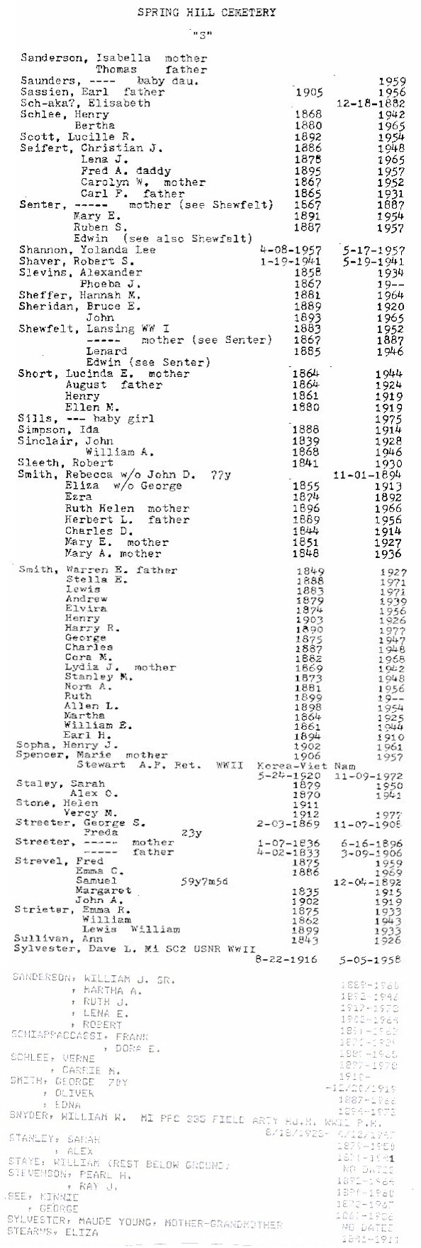
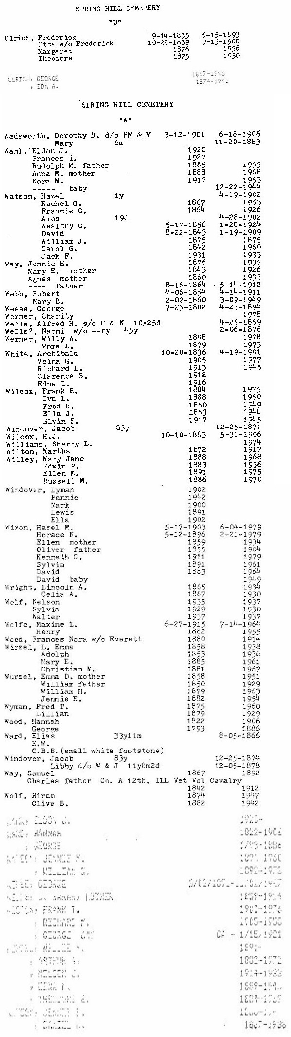
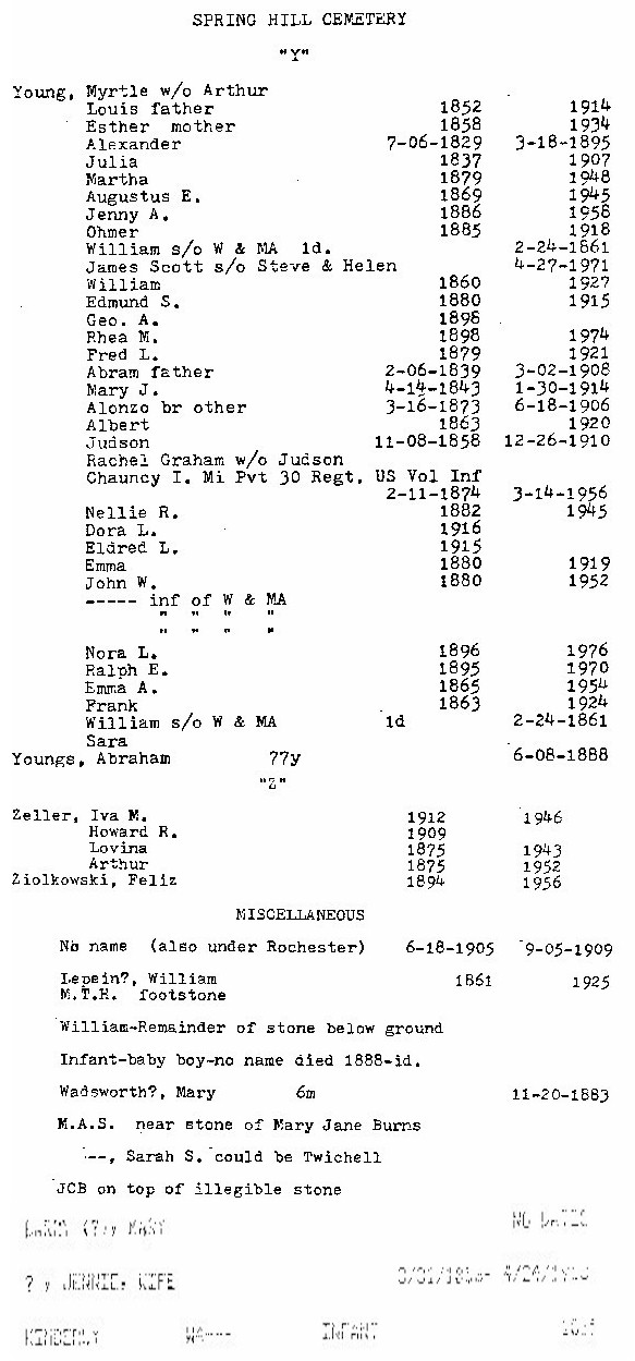
Springhill Cemetery
(aka Spring Hill Cemetery):
Jody Riddick visited this cemetery in August 1999. Jody's relatives are here, the ROBERTS and LOSSING clan dating from the 1850's (and maybe earlier - some tombstones were unreadable) to 1990's. There are recent burials here, although small in number. The cemetary signage is on Fargo Rd. and the cemetery is maintained well. A gravel road runs around the perimeter.
SW 1/4, Sec. 36, Greenwood Twp. At the corner of Fargo and Metcalf
Rds.
A |
B |
C |
D |
E |
F |
G |
H |
IJK |
L |
MN |
OPQ |
R |
S |
T |
UVW |
XYZ & Miscellaneous
| Dababase (partial)
|
Find-A-Grave
Streeter
Cemetery
(See Pettys Cemetery)
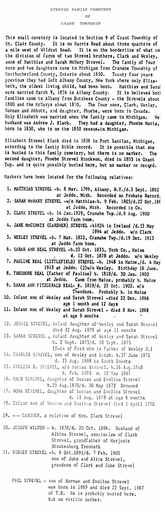
Strevel Cemetery:
Small family owned cemetery. Newer fence with sign,
"Strevel Cemetery 1862 - 1913". Debbie Russell talked with a gentleman and was told a family member was trying to get the township to take over the cemetery when she passed away. This relative lives on the southeast corner of Harris and Wildcat
Rds. He said she has all of the plot maps and records for this cemetery. The cemetery is mowed but many stones were illegible and broken. Not active. Visited in September 1999.
SW 1/4, Sec. 9, Grant Twp. On the north side of Harris Rd. 1/2 mile west of Wildcat Rd.
Find-A-Grave
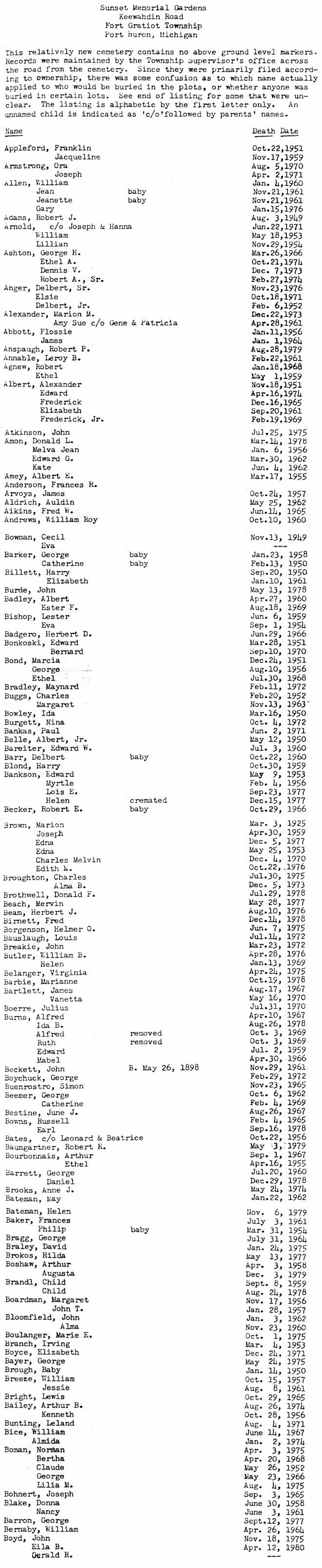
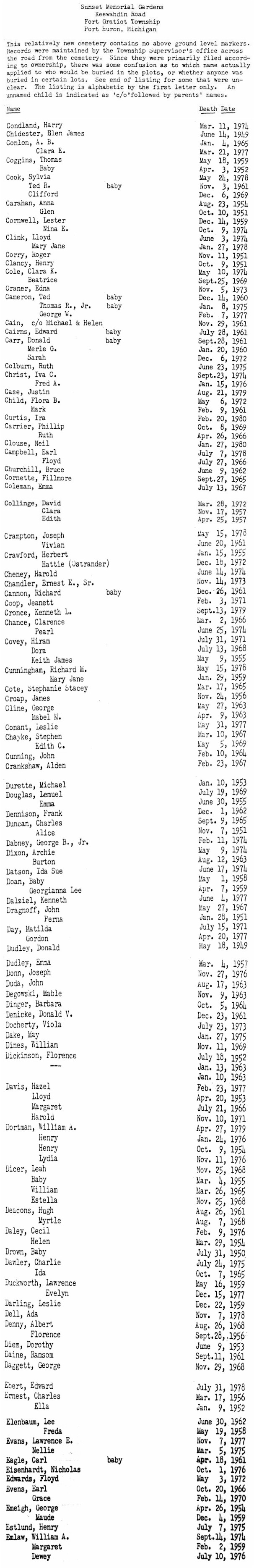
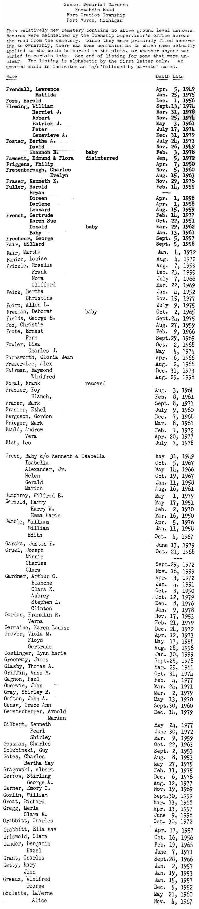
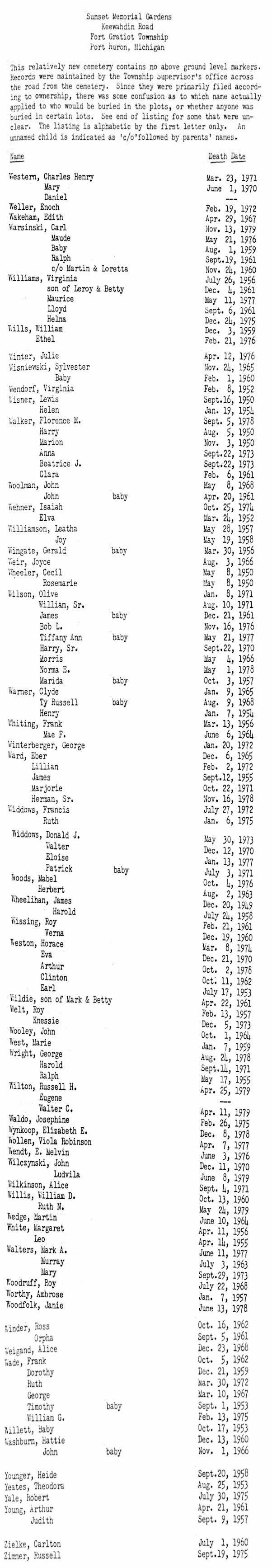
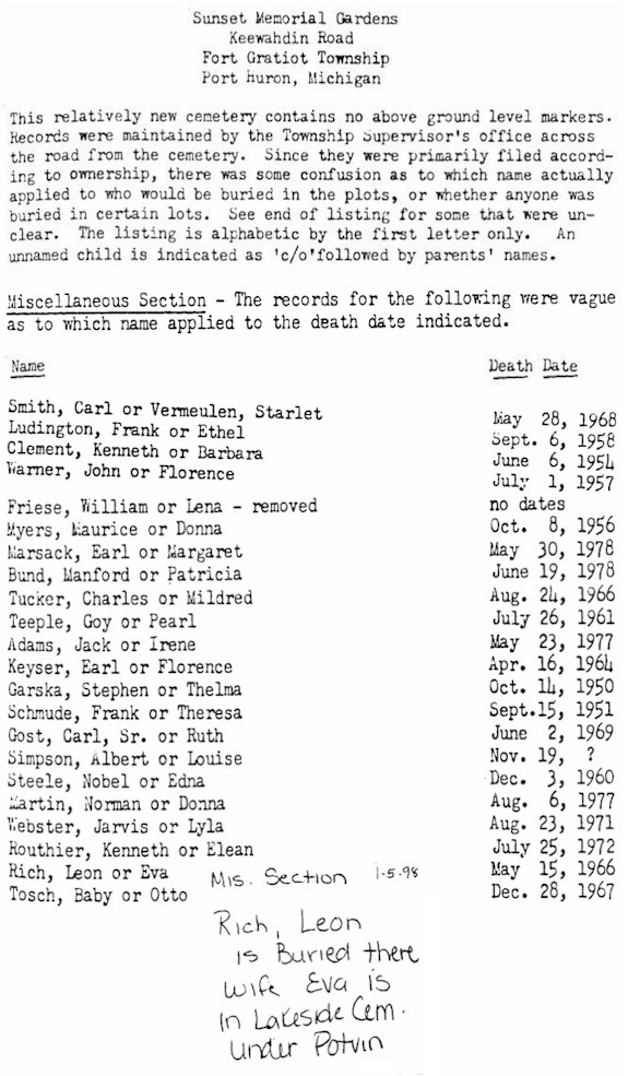
Sunset
Memorial Gardens:
Well-maintained and in current use. Stones appear to be inlaid into the ground instead of vertical. This may be operated by the township, as it shares a driveway with the Fort Gratiot Twp. public works barn, just to the east. Visited in July 1999.
NW 1/4, Sec. 20, Fort Gratiot Twp. On south side of Keewahdin Rd., just west of the curve where M-136 becomes Pine Grove Ave. Across from the township hall and fire station.
Listed on the map printed in the Times Herald, 20 Aug 1995, from information provided by the St. Clair County Family History Group.
Ira Twp., Arnold Rd. near Hessen Rd.
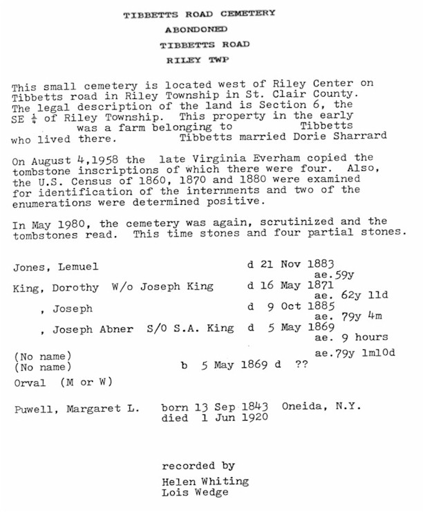
Tibbetts Road Cemetery:
Visited in September 1999. Nancy Schoenherr provides the following account of her visit to this overgrown site:
"The condition of the cemetery is very poor, finding it was almost impossible. We asked a lady living on the road, she directed
us to it. We walked through waist-high brambles, over fallen trees, very "nasty" overgrowth. The first stone was located a
distance from the four others we found there. It was nearly unreadable, but we got the following: Lemuel JONES, Nov. 21, 1883, Aged 50 yrs. Quite a distance away we located the four following: Joseph KING, Oct. 9, 1885, 79 yrs. 4 mos. 10 days; Dorothy KING, May 16, 1871, no age readable; small stones, one unreadable except for the word "David"; the small second stone: Joseph Abner, May, 1864, 9 hrs. old. There were broken pieces of grave stones in the area of the last four, which didn't match up with these stones. There could be more graves there without markers, or markers missing, because the undergrowth of lilies, live-forever, and various other old cemetery type flowers were growing in quite a large area. This was an interesting place to visit; however, there were no Tibbits graves to be found in that area."
Riley Twp., on Tibbetts Rd.
Listed on the map printed in the Times Herald, 20 Aug 1995, from information provided by the St. Clair County Family History Group.
Kenockee Twp., Kilgore Rd. at Plank Rd.
West
Berlin Cemetery
(aka Old Sandhill Cemetery):
Char Ellis tells us that Berlin Twp. has two cemeteries, East Berlin and this one just west of Allenton.
Well-maintained and in current use. Graves date from the 1850s. Added in July 1999.
Township of Berlin,
3892 Hough Road,
Allenton, MI 48002, (810) 784-9969
NW 1/4, Sec. 29, Berlin Twp. On the southwest corner of Almont and Holmes
Rds.
Listed on the map printed in the Times Herald, 20 Aug 1995, from information provided by the St. Clair County Family History Group.
Clyde Twp., Philips Rd. west of Abbotsford Rd.
Whiting
Property:
Listed on the map printed in the Times Herald, 20 Aug 1995, from information provided by the St. Clair County Family History Group.
In the City of St. Clair, on Brown St. (no stones)
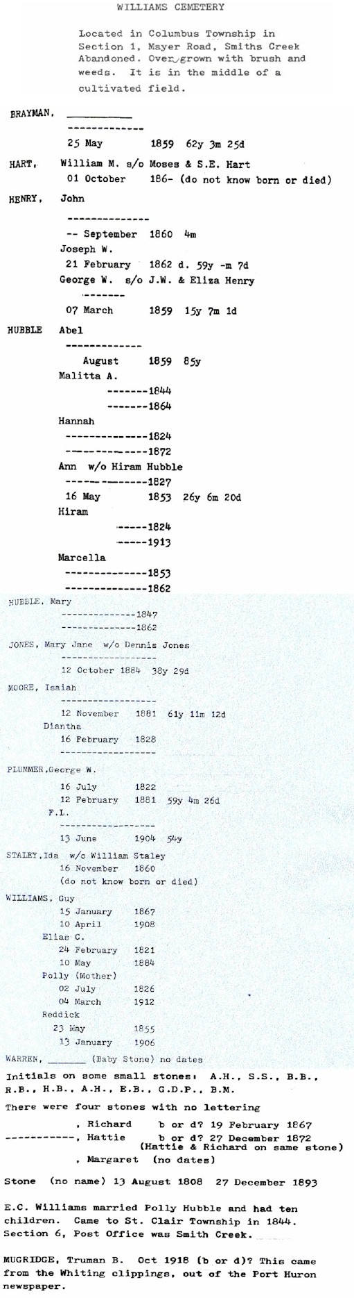
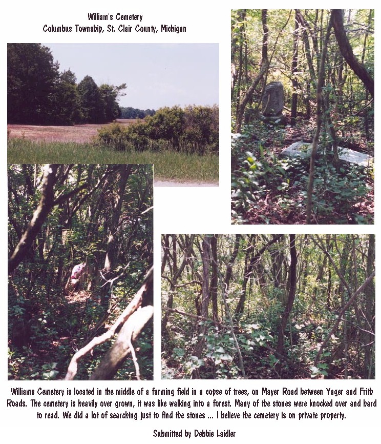
Williams Cemetery:
Listed on the map printed in the Times Herald, 20 Aug 1995, from information provided by the St. Clair County Family History Group.
The cemetery was recently visited by Debbie Laidler,
who reports:
"Williams Cemetery is located in the middle of a farming field in a copse of
trees. It is located on
Mayer Road between Yager Road and Frith Road. It is heavily over grown and I believe it to be private property. Many of the stones were knocked over and hard to read. It was like walking into a forest. We did a lot of searching just to find the
stones ... I will try to keep you posted on our
progress of restoring once we get started. I wanted to send you some pictures that I took while at the cemetery."
Columbus Twp., Mayer Rd. near Smiths Creek
Woodland
Cemetery:
Debbie Russell describes Woodland as "beautifully landscaped, well kept and active. You cross a bridge across a small creek and drive up a small hill." Burials date from 1867 to present. Visited in September 1999.
SW 1/4, Sec. 5, Port Huron Twp. On Lapeer Rd. (old M-21), just east of Herber Dr., behind the Port Huron Twp. fire station.
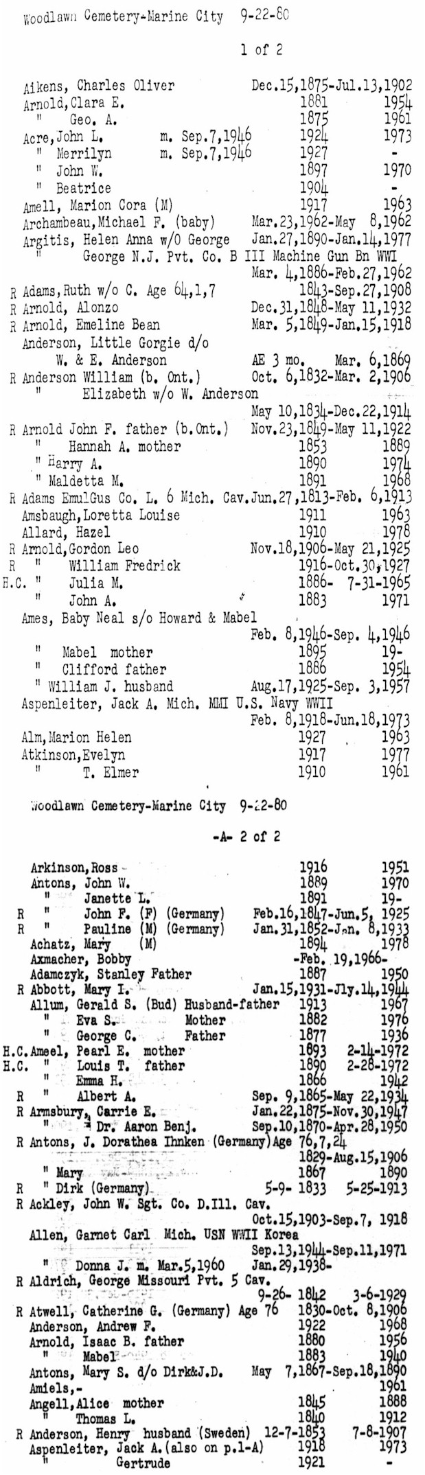
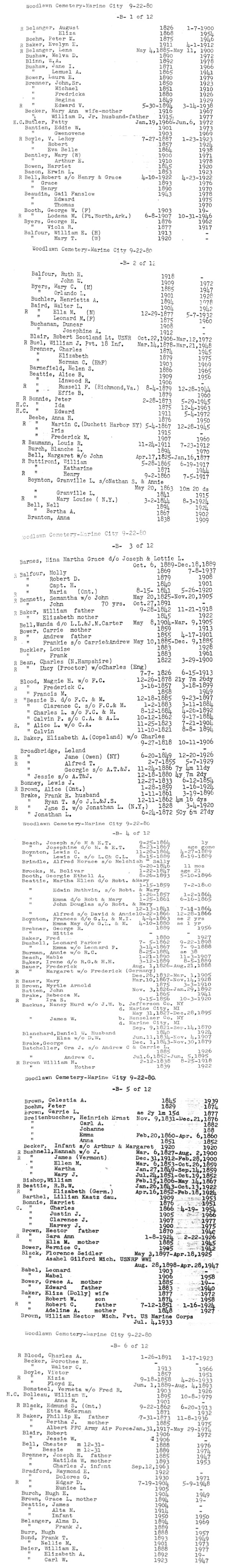
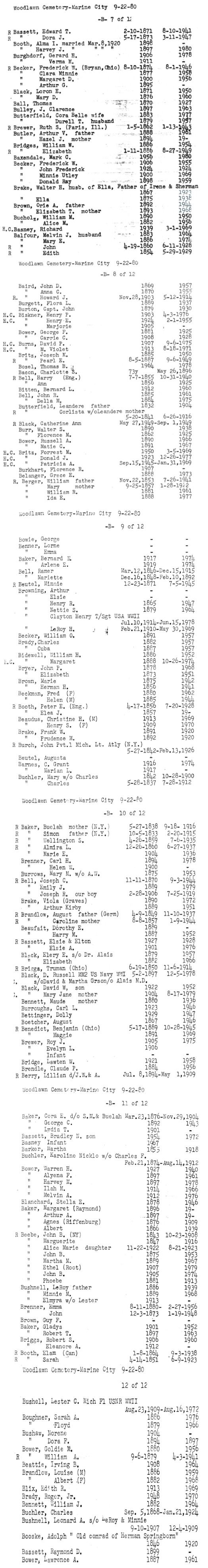
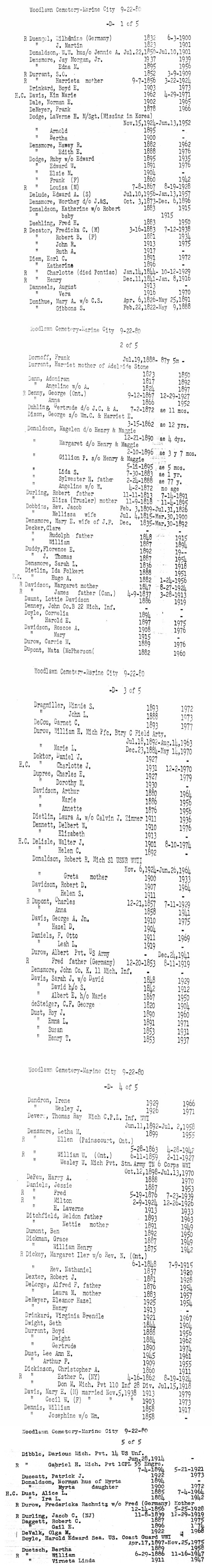
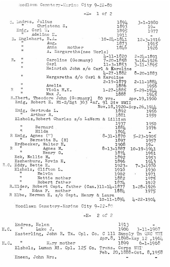
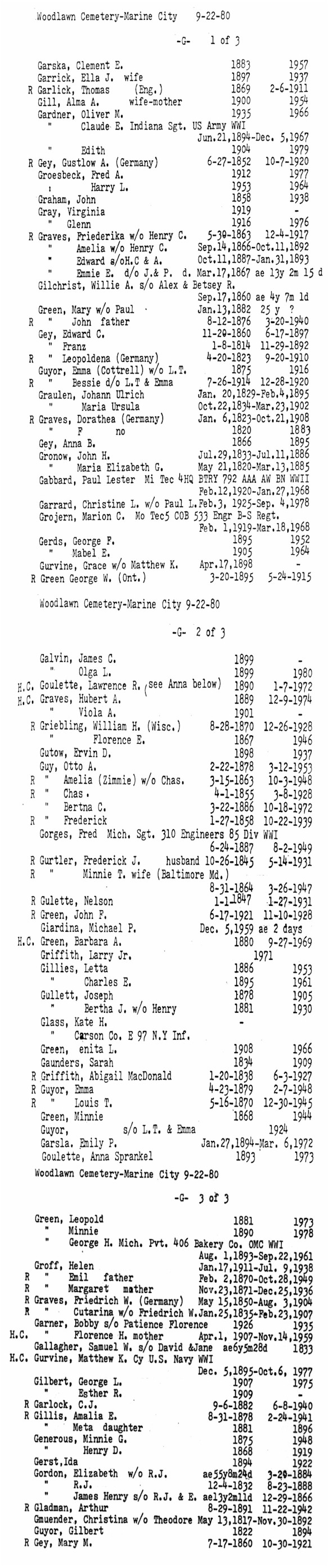
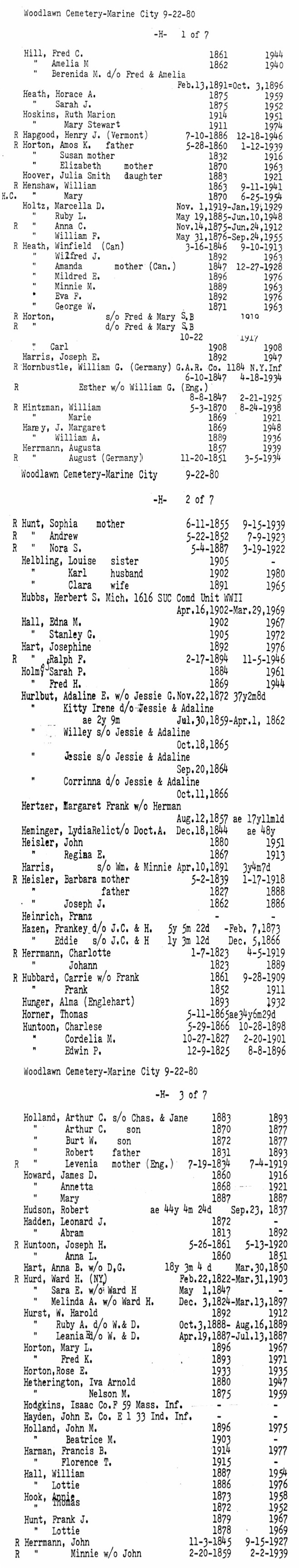
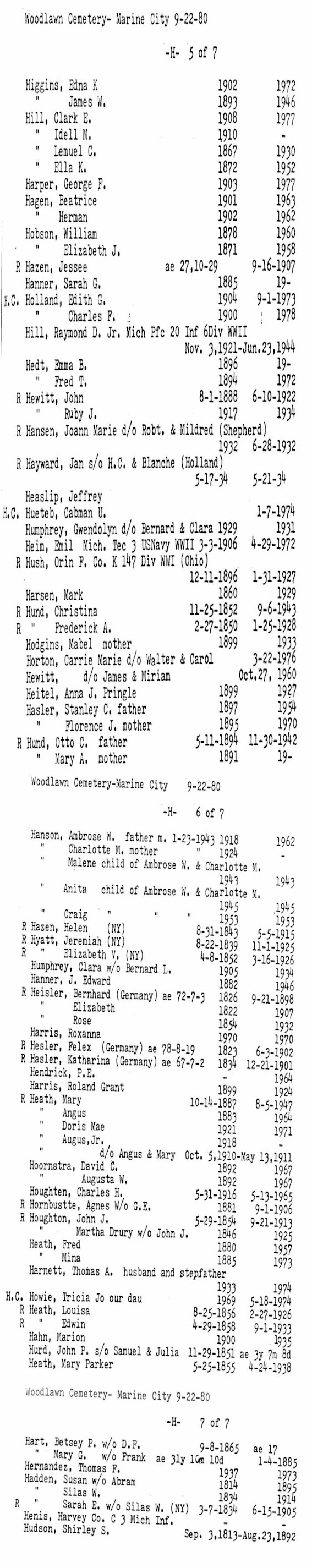
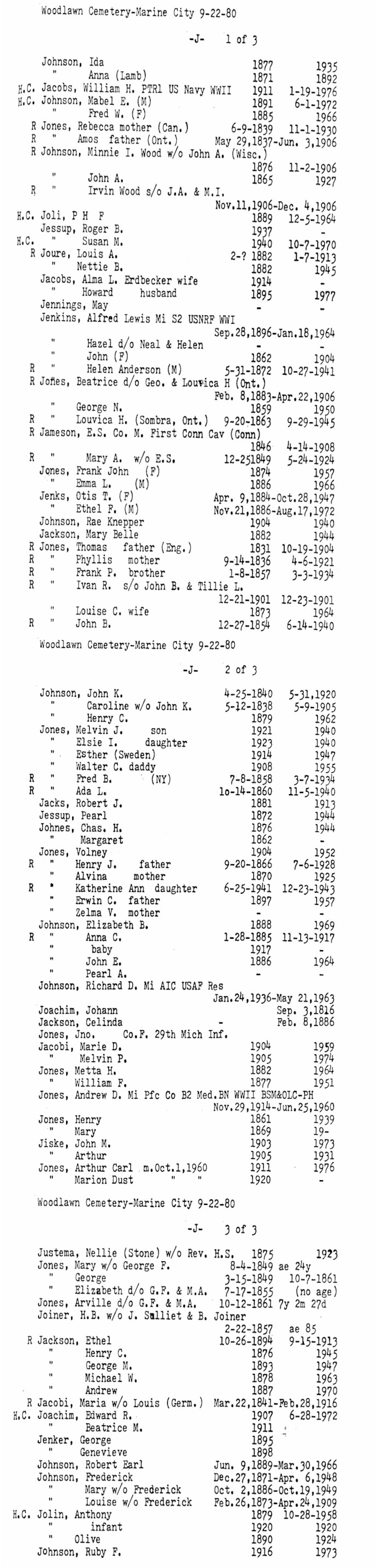
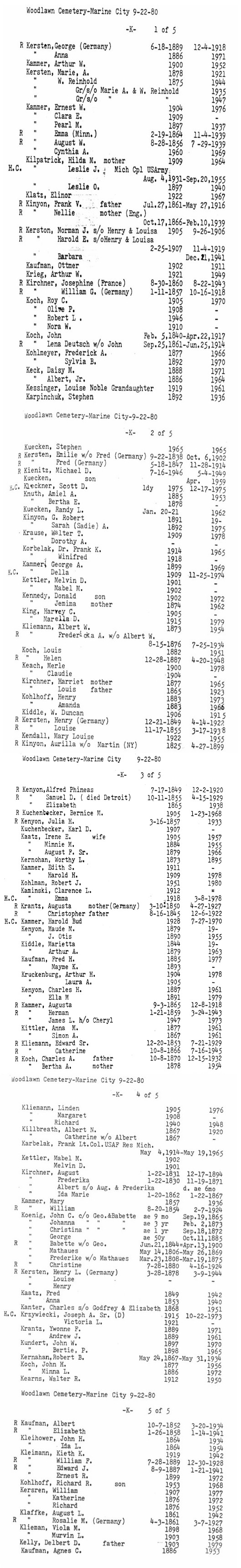
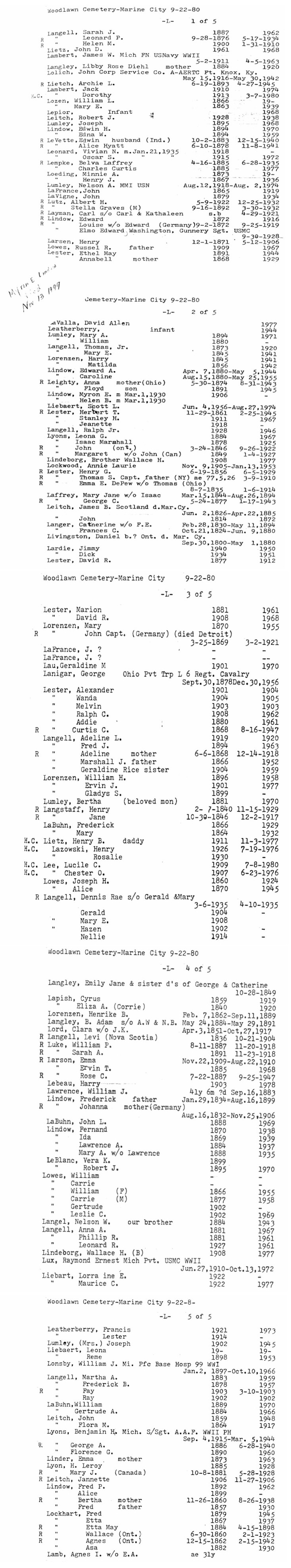
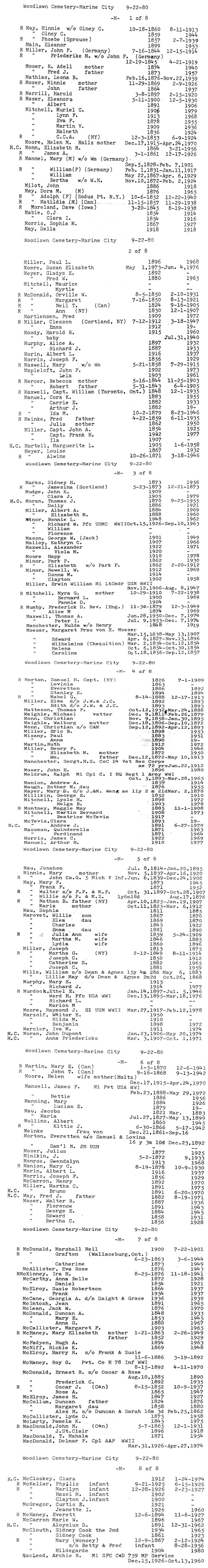
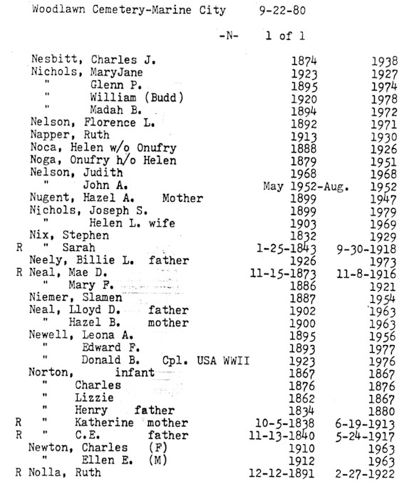
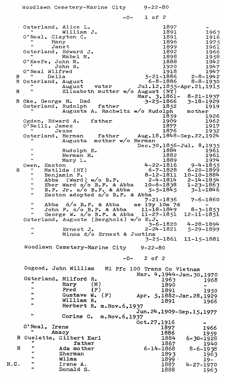
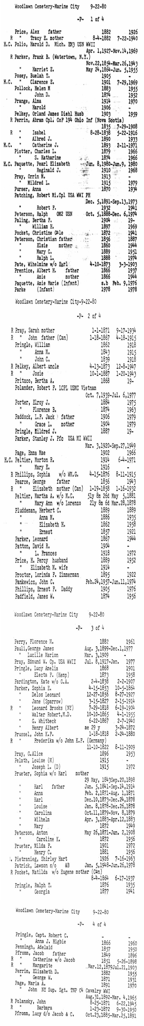
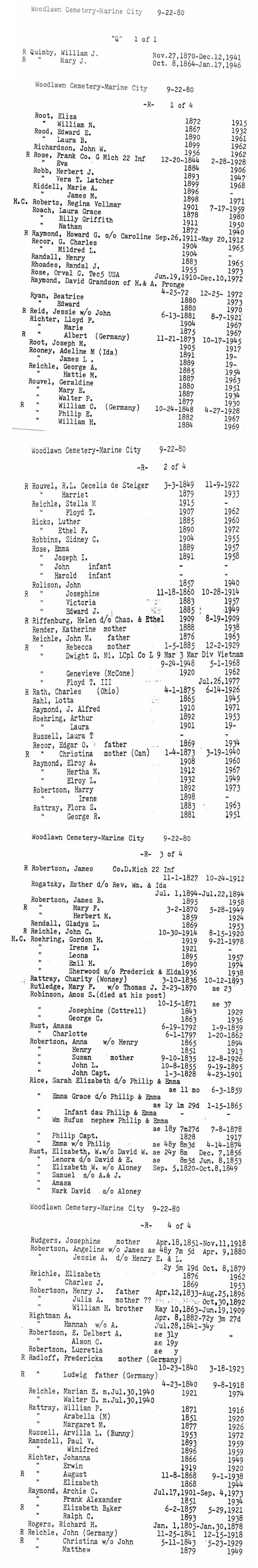
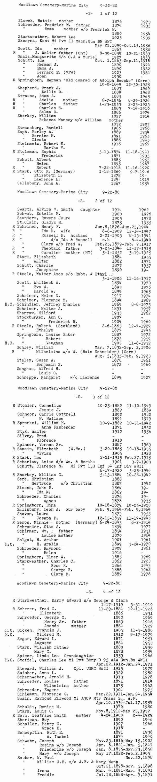
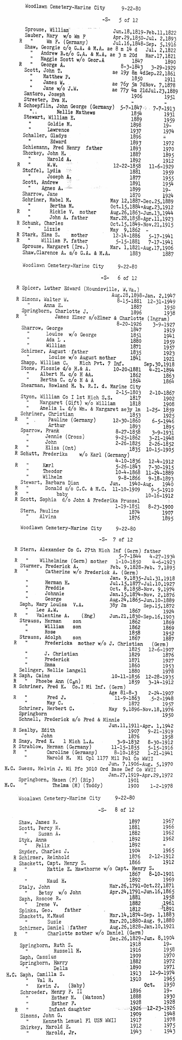
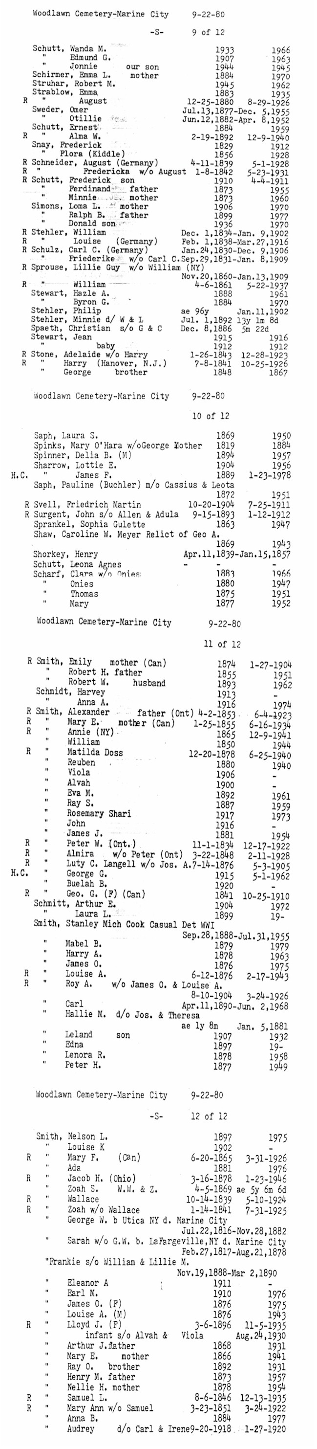
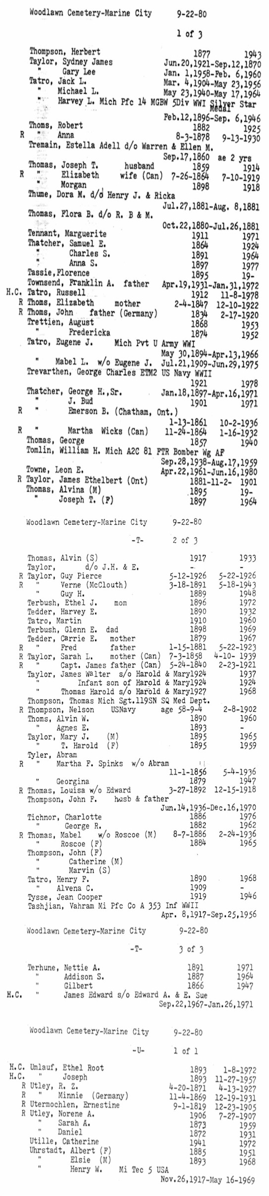
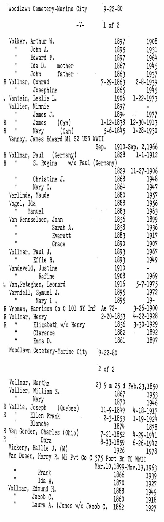
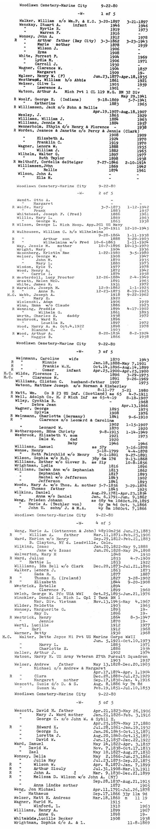
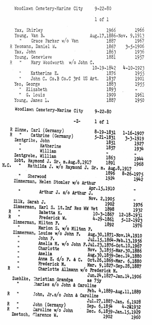
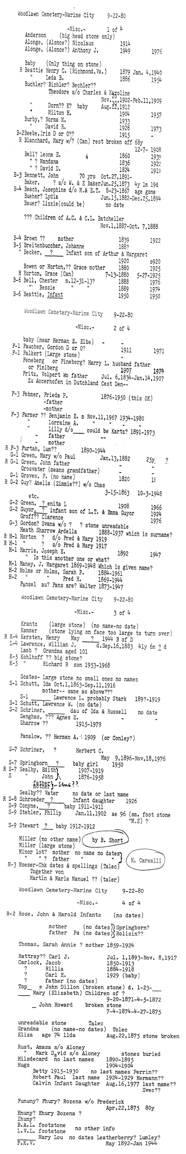
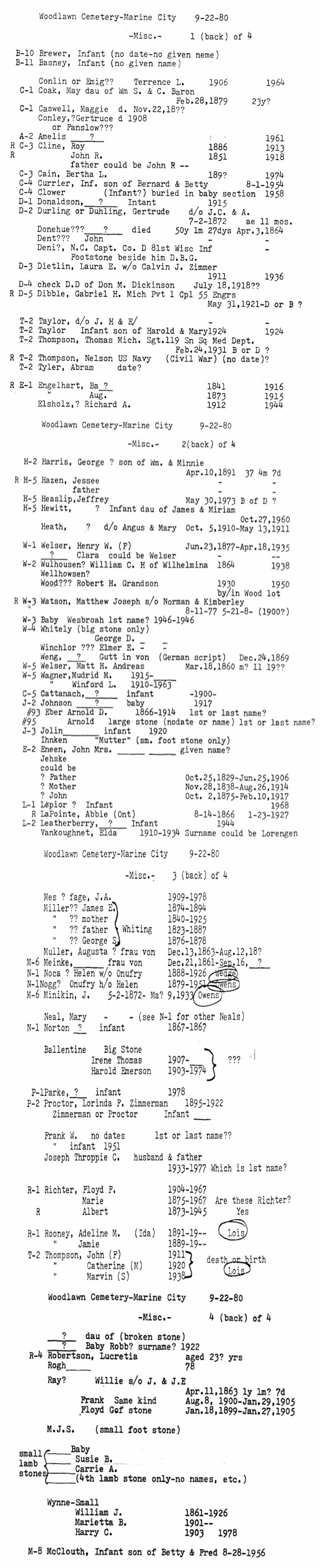
Woodlawn
Cemetery:
In the city of Marine City, at the end of Pleasant St. north of Westminster St. Cemetery is on the east bank of the Belle River.
City-owned public cemetery, in current use and well-maintained.
City of Marine City, Dept. of Public Works,
514 S. Parker St.,
Marine City, MI 48039, (810) 765-9711
|
|